Dawson Highway
The Dawson Highway is a state highway in Queensland, Australia.[1] It runs for 405 km between Gladstone and Springsure where it terminates.[2] From Gladstone to Rolleston it is signed as State Route 60, and then A7 onwards to Springsure. It continues west for another 247 km as Dawson Developmental Road to Tambo on the Landsborough Highway. North of Springsure, A7 becomes the Gregory Highway.
Dawson Highway | |
|---|---|
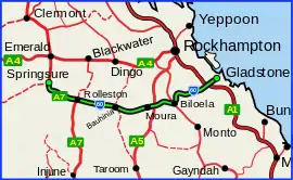 | |
Dawson Highway (green on black) | |
| General information | |
| Type | Highway |
| Length | 405 km (252 mi) |
| Route number(s) |
|
| Former route number | |
| Major junctions | |
| East end | |
| |
| West end | |
| Location(s) | |
| Major settlements | Calliope, Biloela, Banana, Bauhinia, Moura, Rolleston |
| Highway system | |
Many of the towns along the Dawson Highway are coal-mining establishments.
List of towns along the Dawson Highway
Major intersections
| LGA | Location | km | mi | Destinations | Notes |
|---|---|---|---|---|---|
| Gladstone | Gladstone | 0 | 0.0 | south-east - Benaraby (to Bruce Highway southbound) / Bramston Street north-east - Gladstone CBD | Eastern end of Dawson Highway (State Route 60) |
| Calliope | 19.0 | 11.8 | Southbound exit to Bruce Highway | ||
| 19.2 | 11.9 | Northbound exit to Bruce Highway | |||
| 25.7 | 16.0 | ||||
| Banana | Biloela | 120 | 75 | Eastern concurrency terminus with Burnett Highway | |
| 121 | 75 | Western concurrency terminus with Burnett Highway | |||
| Banana | 165 | 103 | Northern concurrency terminus with Leichhardt Highway | ||
| 166 | 103 | Southern concurrency terminus with Leichhardt Highway | |||
| Central Highlands | Rhydding | 240 | 150 | Eastern concurrency terminus with Fitzroy Developmental Road See map of Rhydding[3] | |
| Bauhinia | 258 | 160 | Western concurrency terminus with Fitzroy Developmental Road | ||
| Rolleston | 335 | 208 | Dawson Highway continues north-west as State Route A7 | ||
| Springsure | 405 | 252 | Western end of Dawson Highway | ||
1.000 mi = 1.609 km; 1.000 km = 0.621 mi
| |||||
Upgrade
The existing timber bridges on the Dawson Highway were subject to regular closures due to flooding. The $40 million replacement of 5 timber bridges project was completed in April 2018. The timber bridges were replaced with concrete structures to increase freight efficiency and flood immunity along the Dawson Highway. The new bridges were constructed at; Nine Mile Creek, Catfish Creek, Sheep Station Creek, Maxwelton Creek and Doubtful Creek.[4]
References
- "Queensland Government - Department of Transport and Main Roads - Maps". Archived from the original on 19 March 2018. Retrieved 15 April 2014.
- Hema, Maps (2007). Australia Road and 4WD Atlas (Map). Eight Mile Plains Queensland: Hema Maps. pp. 10–11. ISBN 978-1-86500-456-3.
- Google (1 August 2017). "Rhydding, Queensland" (Map). Google Maps. Google. Retrieved 1 August 2017.
- "Dawson Highway: timber bridge replacement project". The State of Queensland, Department of Transport and Main Roads. 20 December 2018. Archived from the original on 1 May 2019. Retrieved 1 May 2019.