Rorainópolis
Rorainópolis (Portuguese pronunciation: [ʁoɾɐjˈnɔpuʎis]) is a municipality located in the southernmost point of the state of Roraima in Brazil. Its population is 30,782 (as of 2020) and its area is 33,594 km². The city is crossed by the equator.
Rorainópolis | |
|---|---|
| The Municipality of Rorainópolis | |
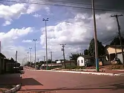 A street in Rorainópolis | |
 Flag  Seal | |
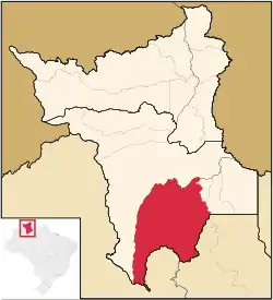 Location of Rorainópolis in the State of Roraima | |
| Coordinates: 00°56′45″N 60°25′04″W | |
| Country | |
| Region | North |
| State | |
| Founded | October 17, 1995 |
| Government | |
| • Mayor | Leandro Pereira da Silva (PSD) |
| Area | |
| • Total | 33.594 km2 (12.971 sq mi) |
| Elevation | 98 m (322 ft) |
| Population (2020 [1]) | |
| • Total | 30,782 |
| • Density | 0.77/km2 (2.0/sq mi) |
| Time zone | UTC-4 |
| HDI (2000) | 0.676 – medium[2] |
| Website | www.rorainopolis.rr.gov.br |
References
- IBGE 2020
- - UNDP
Capital: Boa Vista | ||
| Boa Vista | 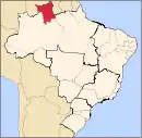 | |
| Nordeste de Roraima | ||
| Caracarai | ||
| Sudeste de Roraima | ||
This article is issued from Wikipedia. The text is licensed under Creative Commons - Attribution - Sharealike. Additional terms may apply for the media files.