Roraima
Roraima (Pemon: roro imã, "parrot mountain" i.e. "Green Peak", Brazilian Portuguese: [ʁoˈɾajmɐ] (![]() listen)) is the northernmost and least populated state of Brazil, located in the Amazon region. It borders the states of Amazonas and Pará and the countries of Venezuela and Guyana. The population is approximately 450,000 (as of 2010), and the capital is Boa Vista. Roraima has fifteen municipalities, the fewest of any Brazilian state. The state has 0.3% of the Brazilian population and is responsible for just 0.17% of the Brazilian GDP.
listen)) is the northernmost and least populated state of Brazil, located in the Amazon region. It borders the states of Amazonas and Pará and the countries of Venezuela and Guyana. The population is approximately 450,000 (as of 2010), and the capital is Boa Vista. Roraima has fifteen municipalities, the fewest of any Brazilian state. The state has 0.3% of the Brazilian population and is responsible for just 0.17% of the Brazilian GDP.
State of Roraima
Estado de Roraima | |
|---|---|
 Flag  Coat of arms | |
| Anthem: Hino de Roraima | |
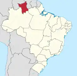 Location of State of Roraima in Brazil | |
| Coordinates: 2°3′N 61°24′W | |
| Country | |
| Founded | September 13, 1943 |
| Capital and Largest City | Boa Vista |
| Government | |
| • Governor | Antônio Denarium (PSL) |
| • Vice Governor | Frutuoso Lins (PTC) |
| • Senators | Chico Rodrigues (DEM) Mecias de Jesus (REPUBLICANOS) Telmário Mota (PROS) |
| Area | |
| • Total | 224,298.98 km2 (86,602.32 sq mi) |
| Area rank | 14th |
| Population (2010)[1] | |
| • Total | 450,479 |
| • Estimate (2019) | 605,761 |
| • Rank | 27th |
| • Density | 2.0/km2 (5.2/sq mi) |
| • Density rank | 27th |
| Demonym(s) | Roraimense |
| GDP | |
| • Year | 2006 estimate |
| • Total | R$ 3,660,000,000 (27th) |
| • Per capita | R$ 9,075 (13th) |
| HDI | |
| • Year | 2017 |
| • Category | 0.752[2] – high (12th) |
| Time zone | UTC-4 (AMT) |
| Postal Code | 69300-000 to 69399-000 |
| ISO 3166 code | BR-RR |
| Website | rr.gov.br |
Geography
.jpg.webp)
The climate of Roraima is tropical with an annual mean temperature of 26 °C (78.8 °F). The state's southern part is located in the Amazon rainforest, while the north has open grassland fields, and there is a small strip of savanna to the east. The state is rich in mineral deposits, especially gold, diamonds, cassiterite, bauxite, marble, and copper. Many of these deposits are located in indigenous reserves, and illegal mining has resulted in frequent conflicts with the native population, especially the Yanomami and the Macuxi and allied groups.
The Monte Roraima National Park is located around one of the highest mountains of both Venezuela (outside of the Andes) and Brazil, and the highest in Guyana, a 2,875 m (9,432 ft) high tepui known as Monte Roraima. Only a small fraction of the mountain is in Brazilian territory, however, and the highest point of the Brazilian part is at 2,734 metres (8,970 ft).[3]
Climate
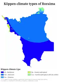
Except for the higher mountains where the climate is cooler but very wet, Roraima has an equatorial climate. This is a type of tropical climate in which there is no dry season: all months have mean precipitation values of at least 60 mm. It is usually found at latitudes within five degrees of the equator, which are dominated by the Intertropical Convergence Zone. The equatorial climate is denoted Af in the Köppen climate classification. Tropical rainforest is the natural vegetation in the equatorial regions.
History
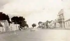
Since the early 16th century, the region now considered the state of Roraima was disputed territory because of its rich mineral reserves. It was sought by the Spanish, Portuguese, Dutch, and English until the beginning of the 20th century. But in 1943, together with a section from the state of Amazonas, the Federal Government created the territory of Rio Branco, which became Roraima in 1962. In 1988, Roraima became a state by decision of the National Congress. The name of the state was taken from Mount Roraima, whose name comes from the Pemon words "roroi" ("cyan") and "ma" ("large"). One of the main archaeological sites is the Pedra Pintada, Roraima, with ancient rock art and engravings.
Demographics
According to the IBGE in 2007 there were 405,000 people residing in the state. The population density was 1.8 inhabitants/km2.
Urbanization: 80.3% (2004); Population growth: 4.6% (1991–2000); Houses: 97,465 (2005).[4]
The latest PNAD (National Household Survey) data reveal the following numbers: 278,000 Brown (Multiracial) people (68.8%), 81,000 White people (20.0%), 29,000 Black people (7.4%), 15,000 Asian or Amerindian people (3.8%).[5]
Ethnic groups found in Roraima include: Amerindians, Portuguese, Africans, Spanish, Venezuelans, and Lebanese.
The Brazilian Indian Agency, (FUNAI) estimates the state's indigenous population at 30,715.[6] The largest indigenous groups are the Macuxi (16,500)[7] and the better-known Yanomami (11,700).[8] Much of the state's indigenous population lives in several large, legally recognized indigenous reserves and a number of smaller ones, totalling 46.13% of the land area of the state.[9]
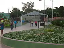
Largest cities
Economy
The service sector is the largest component of the GDP at 87.5%, followed by the industrial sector at 8.7%. Agriculture represents 3.8% of GDP (2004). Roraima exports: wood 74%, leather 22.6% (2002).
Share of the Brazilian economy: 0.1% (2005).
Additional statistics
- Vehicles: 187,209 (August, 2015)
- Mobile phones: 148,000 (April, 2007)
- Telephones: 67,000 (April, 2007)
- Cities: 15 (2015)[11]
Education
Portuguese is the official national language and thus the primary language taught in schools. English and Spanish are part of the official high school curriculum.
Educational institutions
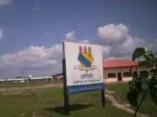
- Universidade Federal de Roraima (UFRR) (Federal University of Roraima);
- Universidade Estadual de Roraima (UERR) (State University of Roraima);
- Instituto Federal de Educação, Ciência e Tecnologia de Roraima (IFRR);
- Faculdade de Ciências Humanas, Biológicas e da Saúde (FCHBS);
- Faculdade de Teologia de Boa Vista (Fatebov);
- Faculdade Roraimense de Ensino Superior (Fares);
- Faculdades Cathedral - Boa Vista (Cathedral-Boa Vista);
- Faculdade Atual da Amazônia - (FAA)
Sports
Football
As in the rest of Brazil, football is the most popular sport. The city's major teams are:
- Atlético Roraima Clube
- Baré Esporte Clube
- Grêmio Atlético Sampaio GAS
- Náutico Futebol Clube
- Associação Esportiva Real
- São Raimundo Esporte Clube
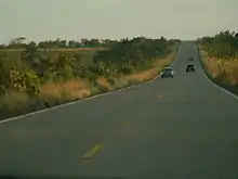
Infrastructure
International Airport
Boa Vista International Airport opened on February 19, 1973, and underwent its first big remodeling in 1998. The passenger terminal, runway, and apron were all enlarged, and a separate taxiway was built. The airport has the capacity to receive 675,000 passengers a year.
Flag
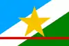
The blue of the flag represents the pure air and the sky of Roraima, the white strip symbolizes peace, and the green to the right represents the forests and fields. The star - symbolizing the state in the national flag of Brazil - is yellow, which symbolizes the mineral resources of the state. The red line at the bottom stands for the equator, which cuts through the state. The flag was designed by the artist Mário Barreto and was adopted by Law No.133 of June 14, 1996.
References
- "IBGE". Retrieved 12 October 2017.
- "Radar IDHM: evolução do IDHM e de seus índices componentes no período de 2012 a 2017" (PDF) (in Portuguese). PNUD Brasil. Retrieved 18 April 2019.
- "IBGE recalculates altitude of Mount Roraima". IBGE (Brazilian Institute of Geography and Statistics). 2005-07-29. Retrieved 2009-08-30.
- Source: PNAD.
- Síntese de Indicadores Sociais 2007 (PDF) (in Portuguese). Roraima, Brazil: IBGE. 2007. ISBN 85-240-3919-1. Retrieved 2007-07-18.
- "Funai". Retrieved 23 May 2015.
- http://www.socioambiental.org/pib/epi/verbetinho/comfoto/macuxi.htm
- http://www.socioambiental.org/pib/epienglish/yanomami/yanomami.shtm.
- "Notícias socioambientais :: Socioambiental". Retrieved 23 May 2015.
- "Estimativas da população residente nos municípios brasileiros com data de referência em 1º de julho de 2011" [Estimates of the Resident Population of Brazilian Municipalities as of July 1, 2011] (in Portuguese). Brazilian Institute of Geography and Statistics. 30 August 2011. Archived from the original (PDF) on 31 August 2011. Retrieved 31 August 2011.
- Source: IBGE.
External links
- (in Portuguese) Official Website
- (in English) Brazilian Tourism Portal
| Wikimedia Commons has media related to Roraima. |
Capital: Boa Vista | ||
| Boa Vista | 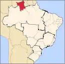 | |
| Nordeste de Roraima | ||
| Caracarai | ||
| Sudeste de Roraima | ||
| North | |
|---|---|
| Northeast | |
| Center-West | |
| Southeast | |
| South | |
| |
| Authority control |
|---|
