Rough Island, Scotland
Rough Island is a 20-acre (8 ha) uninhabited tidal island located in the Rough Firth off the Solway Firth, Scotland, in the historical county of Kirkcudbrightshire the same region where the River Urr flows into the Solway. The isle of Rough is 79 feet (24 metres) at its highest point.[1]
- "Rough Island" is also used as a translation of "Garbh Eilean", a common Scottish name for islands
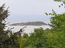 Rough Island, opposite Rockcliffe | |
| Location | |
|---|---|
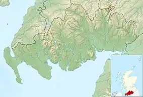 Rough Island Rough Island shown within Dumfries and Galloway | |
| Coordinates | |
| Physical geography | |
| Area | 8 hectares (0.03 sq mi) |
| Administration | |
| Sovereign state | United Kingdom |
| Country | Scotland |
| Council area | Dumfries and Galloway |
| Demographics | |
| Population | 0 |
National Trust for Scotland Ownership
Since 1937 Rough Island has been in the ownership of the National Trust for Scotland. The island is now a bird sanctuary.
Accessibility
Accessible across the causeway from Kippford when the tides allow or across the mudflats from Rockcliffe, the isle of Rough can be walked to from the Scottish mainland.[2] As the island is a bird sanctuary visitors should avoid travelling to the island during the months of May and June to avoid disturbing the nesting oystercatchers and ringed plovers.[3] The islands' causeway is flooded and underwater for 5 (five) hours during high tide and visitors to the island need to take this into account when travelling there.
See also
References
- Gazetteer for Scotland
- Caton, Peter (2011) No Boat Required - Exploring Tidal Islands. Matador.
- Tourism website
External links
- National Trust for Scotland page
- Map sources for Rough Island, Scotland