Royal, Nebraska
Royal is a village in Antelope County, Nebraska, United States. The population was 63 at the 2010 census.
Royal, Nebraska | |
|---|---|
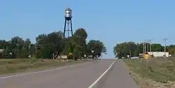 Royal, seen from the east along U.S. Highway 20 | |
 Location of Royal, Nebraska | |
| Coordinates: 42°20′1″N 98°7′26″W | |
| Country | United States |
| State | Nebraska |
| County | Antelope |
| Established | 1890[1] |
| Area | |
| • Total | 0.14 sq mi (0.37 km2) |
| • Land | 0.14 sq mi (0.37 km2) |
| • Water | 0.00 sq mi (0.00 km2) |
| Elevation | 1,880 ft (573 m) |
| Population | |
| • Total | 63 |
| • Estimate (2019)[4] | 58 |
| • Density | 408.45/sq mi (158.23/km2) |
| Time zone | UTC-6 (Central (CST)) |
| • Summer (DST) | UTC-5 (CDT) |
| ZIP code | 68773 |
| Area code(s) | 402 |
| FIPS code | 31-42495[5] |
| GNIS feature ID | 0832761[6] |
History
The community was established in 1890 (or 1880[7]), and was originally named "Savage".[1] The community was renamed after Royal Thayer, who helped establish the post office.[8]
An unusual point in the town's history is the defunct "Zoo Nebraska", which was near Royal. After some chimpanzees escaped, and were killed, the zoo gained some national attention[9] and then ultimately collapsed.[10] In 2019 a book about the zoo and the incident was released.[11][12][13]
Geography
Royal is located at 42°20′1″N 98°7′26″W (42.333688, −98.123833).[14]
According to the United States Census Bureau, the village has a total area of 0.14 square miles (0.36 km2), all land.[15]
Demographics
| Historical population | |||
|---|---|---|---|
| Census | Pop. | %± | |
| 1920 | 202 | — | |
| 1930 | 217 | 7.4% | |
| 1940 | 193 | −11.1% | |
| 1950 | 157 | −18.7% | |
| 1960 | 93 | −40.8% | |
| 1970 | 86 | −7.5% | |
| 1980 | 86 | 0.0% | |
| 1990 | 81 | −5.8% | |
| 2000 | 75 | −7.4% | |
| 2010 | 63 | −16.0% | |
| 2019 (est.) | 58 | [4] | −7.9% |
| U.S. Decennial Census[16] | |||
2010 census
At the 2010 census there were 63 people, 29 households, and 14 families living in the village. The population density was 450.0 inhabitants per square mile (173.7/km2). There were 38 housing units at an average density of 271.4 per square mile (104.8/km2). The racial makeup of the village was 98.4% White and 1.6% from two or more races. Hispanic or Latino of any race were 1.6%.[3]
Of the 29 households 24.1% had children under the age of 18 living with them, 37.9% were married couples living together, 3.4% had a female householder with no husband present, 6.9% had a male householder with no wife present, and 51.7% were non-families. 41.4% of households were one person and 17.2% were one person aged 65 or older. The average household size was 2.17 and the average family size was 2.79.
The median age in the village was 45.1 years. 19% of residents were under the age of 18; 7.9% were between the ages of 18 and 24; 22.2% were from 25 to 44; 36.5% were from 45 to 64; and 14.3% were 65 or older. The gender makeup of the village was 55.6% male and 44.4% female.
2000 census
At the 2000 census there were 75 people, 34 households, and 21 families living in the village. The population density was 523.6 people per square mile (206.8/km2). There were 40 housing units at an average density of 279.3 per square mile (110.3/km2). The racial makeup of the village was 100.00% White.[5] Of the 34 households 29.4% had children under the age of 18 living with them, 58.8% were married couples living together, and 38.2% were non-families. 38.2% of households were one person and 23.5% were one person aged 65 or older. The average household size was 2.21 and the average family size was 2.90.
The age distribution was 22.7% under the age of 18, 8.0% from 18 to 24, 26.7% from 25 to 44, 20.0% from 45 to 64, and 22.7% 65 or older. The median age was 42 years. For every 100 females, there were 87.5 males. For every 100 females age 18 and over, there were 123.1 males.
The median household income was $27,292, and the median family income was $50,000. Males had a median income of $34,063 versus $18,125 for females. The per capita income for the village was $13,414. There were 7.7% of families and 6.6% of the population living below the poverty line, including no under eighteens and 19.0% of those over 64.
Parks and recreation
The Ashfall Fossil Beds State Historical Park is located six miles from Royal. The park features well preserved skeletons of prehistoric animals, and is a joint project of the Nebraska Game and Parks Commission and the University of Nebraska State Museum.[1][17]
References
- "Royal Nebraska". Royal Nebraska. Retrieved October 19, 2012.
- "2019 U.S. Gazetteer Files". United States Census Bureau. Retrieved July 26, 2020.
- "U.S. Census website". United States Census Bureau. Retrieved 2012-06-24.
- "Population and Housing Unit Estimates". United States Census Bureau. May 24, 2020. Retrieved May 27, 2020.
- "U.S. Census website". United States Census Bureau. Retrieved 2008-01-31.
- "US Board on Geographic Names". United States Geological Survey. 2007-10-25. Retrieved 2008-01-31.
- Burr, George L. (1921). History of Hamilton and Clay Counties, Nebraska, Volume 1. S.J. Clarke Publishing Company. p. 96.
- "Profile for Royal, Nebraska, NE". ePodunk. Retrieved October 19, 2012.
- AP via Fox News
- Norfolk Daily News
- "Hansen: The short, strange journey of Nebraska's smallest zoo, coming to bookstores near you"
- Publisher's Weekly
- First Things
- "US Gazetteer files: 2010, 2000, and 1990". United States Census Bureau. 2011-02-12. Retrieved 2011-04-23.
- "US Gazetteer files 2010". United States Census Bureau. Archived from the original on 2012-07-02. Retrieved 2012-06-24.
- "Census of Population and Housing". Census.gov. Retrieved June 4, 2015.
- "Ashfall Fossil Beds State Historical Park". University of Nebraska State Museum. Retrieved October 19, 2012.
External links
| Wikimedia Commons has media related to Royal, Nebraska. |
Municipalities and communities of Antelope County, Nebraska, United States | ||
|---|---|---|
| Cities | Map of Nebraska highlighting Antelope County | |
| Villages | ||
| Townships | ||
| Footnotes | ‡This populated place also has portions in an adjacent county or counties | |
| ||
| Authority control |
|---|