Ruatahuna
Ruatahuna is a town in the northeast of New Zealand's North Island, 90 kilometres west of Gisborne, and 18 kilometres northwest of Lake Waikaremoana. It is situated on the unsealed part of SH38, from Wai-O-Tapu via Murupara to Wairoa.
Ruatahuna | |
|---|---|
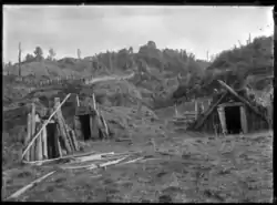 Food storage pits.for kumara (sweet potato) at Ruatahuna in 1930 | |
 Ruatahuna | |
| Coordinates: 38°33′S 176°57′E | |
| Country | |
| Region | Bay of Plenty |
| Territorial authority | Whakatāne District |
| Ward | Galatea-Murupara |
A small town in the upper reaches of the Whakatāne River, Ruatahuna is in the remote country of the Ureweras, and is surrounded on three sides by the former Te Urewera National Park. The area was the site of much action during the New Zealand Wars of the 1860s and 1870s.
It is a subdivision of the Galatea-Murupara ward of the Whakatāne District.[1]
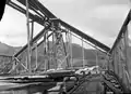 Te Whai-a-te-Motu meeting house under construction in Ruatahuna, 1910s
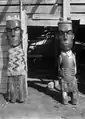 Maori wooden carvings at Te Whai-a-te Motu, Mataatua
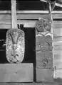 Maori wooden carvings at Te Whai-a-te Motu, Mataatua
Marae
Ruatahuna is within the rohe (tribal area) of Tūhoe, and has several marae affiliated with Tūhoe hapū:[2][3][4]
- Mātaatua Marae and Te Whaia a Te Motu meeting house, affiliated with Te Urewera.
- Ōhāua or Ōhāua te Rangi Marae and Te Poho-o-Potiki meeting house, affiliated with Ngāti Rongo.
- Ōpūtao Marae and Te Ngawari meeting house, affiliated with Ngāti Tāwhaki.
- Ōtekura Marae and Te Ohaki meeting house, affiliated with Tamakaimoana.
- Pāpueru Marae and Te Whatu o Te Kanohi meeting house, affiliated with Ngāti Tāwhaki.
- Tātāhoata Marae and Te Tapuae meeting house, affiliated with Ngāi Te Riu.
- Tīpapa Marae and Kākahu Tāpiki meeting house, affiliated with Kākahu Tāpiki.
- Te Umuroa Marae and Te Poho-o-Parahaki meeting house, affiliated with Ngāti Manunui.
- Uwhiārae Marae and Te Paena meeting house, affiliated with Ngāi Te Paena.
- Te Wai-iti Marae and Te Poho o Kuri Kino meeting house, affiliated with Ngāti Kurī Kino.
In October 2020, the Government committed $3,996,258 from the Provincial Growth Fund to upgrade Mātaatua, Ōhāua, Pāpueru, Tātāhoata, Uwhiārae Te Wai-iti Marae, and 2 other marae, creating 79 jobs. It also committed $1,327,283 to upgrade Tīpapa Marae and 3 others.[5]
Education
Te Kura Kaupapa Māori o Huiarau is a co-educational state Māori language immersion area school for Year 1 to 13 students,[6] with a roll of 75 as of March 2020.[7]
References
- "Murupara Community Board". Whakatane District Council. Retrieved 13 December 2015.
- "Te Kāhui Māngai directory". tkm.govt.nz. Te Puni Kōkiri.
- "Māori Maps". maorimaps.com. Te Potiki National Trust.
- "Marae in Tuhoe". ngaituhoe.iwi.nz. Tuhoe.
- "Marae Announcements" (Excel). growregions.govt.nz. Provincial Growth Fund. 9 October 2020.
- "Te Kura Kaupapa Māori o Huiarau Ministry of Education School Profile". educationcounts.govt.nz. Ministry of Education.
- "Te Kura Kaupapa Māori o Huiarau Education Review Office Report". ero.govt.nz. Education Review Office.
