Saint-Alban, Quebec
Saint-Alban is a municipality in the Capitale-Nationale region of Quebec, Canada. The place is known for its caves and crevices, and the gorge of the Sainte-Anne River. The "gorge" sector of the Sainte-Anne River is famous for its rock climbing walls.
Saint-Alban | |
|---|---|
_-_Saint-Alban.JPG.webp) | |
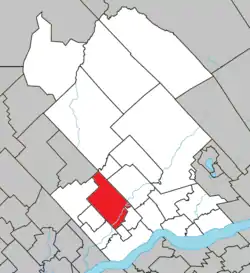 Location within Portneuf RCM | |
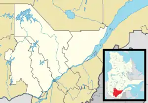 Saint-Alban Location in central Quebec | |
| Coordinates: 46°43′00″N 72°05′00″W[1][2] | |
| Country | |
| Province | |
| Region | Capitale-Nationale |
| RCM | Portneuf |
| Settled | 1830 |
| Constituted | December 31, 1991 |
| Government | |
| • Mayor | Lynn Audet |
| • Federal riding | Portneuf—Jacques-Cartier |
| • Prov. riding | Portneuf |
| Area | |
| • Total | 159.10 km2 (61.43 sq mi) |
| • Land | 149.53 km2 (57.73 sq mi) |
| Population (2011)[4] | |
| • Total | 1,225 |
| • Density | 8.2/km2 (21/sq mi) |
| • Pop 2006-2011 | |
| • Dwellings | 764 |
| Time zone | UTC−05:00 (EST) |
| • Summer (DST) | UTC−04:00 (EDT) |
| Postal code(s) | |
| Area codes | 367, 418, 581 |
| Highways | |
| Website | st-alban |
History
The first settlers, coming from Saint-Ambroise-de-la-Jeune-Lorette, Deschambault, Grondines, and Sainte-Anne-de-la-Perade, began clearing the area around 1830. In 1851, a mill was built that led to the development of the village. In 1856, the parish was founded, followed by the post office in 1857, and the parish municipality in 1860. Its official full name was Saint-Alban-d'Alton, and named after Saint Alban, the first martyr in Britain in the third century. Alton refers to its location in the geographic township of Alton, formed in 1841, and named after a town in Hampshire, England.[1]
In January 1918, the village centre itself separated from the parish municipality and was incorporated as the Village Municipality of Saint-Alban. In 1991, the parish and village municipalities merged again to form the new Municipality of Saint-Alban.[1]
Demographics
Population trend:[7]
- Population in 2011: 1225 (2006 to 2011 population change: 7.6%)
- Population in 2006: 1138
- Population in 2001: 1170
- Population in 1996: 1159
- Population in 1991: 1176
Private dwellings occupied by usual residents: 552 (total dwellings: 764)
Mother tongue:
Gallery
See also
Further reading
- Mariages de St-Alban (comté Portneuf) 1856-1900 (in French), compiled by Benoit Pontbriand, agronomist, 1965, 63 pages.
References
- Commission de toponymie du Québec (24 April 1992). "Saint-Alban (municipalité)". Toponymie.gouv.qc.ca (in French). Retrieved 6 June 2019.
- Natural Resources Canada (24 April 1992). "Canadian Geographical Names Data Base: Saint-Alban (EPIMB)". www4.RNCAN.gc.ca. Retrieved 6 June 2019.
- Ministère des Affaires municipales, des Régions et de l'Occupation du territoire - Répertoire des municipalités: Saint-Alban
- Statistics Canada 2011 Census - Saint-Alban census profile
- "History of Saint-Alban". Saint Alban (in French). City of Saint Alban. Retrieved 4 March 2016.
- "Landslides". Get Prepared. Public Safety Canada. Retrieved 4 March 2016.
- Statistics Canada: 1996, 2001, 2006, 2011 censuses
External links
- Official website
 (in French)
  Media related to Saint-Alban, Quebec at Wikimedia Commons
 Geographic data related to Saint-Alban at OpenStreetMap
| Authority control |
|---|
Adjacent Municipal Subdivisions | |
|---|---|
| Cities & towns | |
|---|---|
| Municipalities | |
| Parishes | |
| Unorganized territories | |
| |