Cap-Santé
Cap-Santé is a town in the Canadian province of Quebec. It is the county seat of Portneuf Regional County Municipality and was as well the county seat of the designated Portneuf County.
Cap-Santé | |
|---|---|
 | |
.svg.png.webp) Coat of arms | |
| Motto(s): Ex Unitate Vires | |
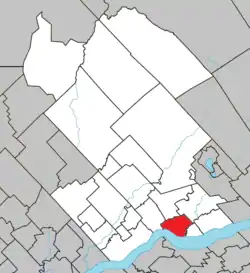 Location within Portneuf RCM | |
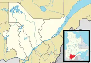 Cap-Santé Location in central Quebec | |
| Coordinates: 46°40′N 71°47′W[1] | |
| Country | |
| Province | |
| Region | Capitale-Nationale |
| RCM | Portneuf |
| Settled | 1679 |
| Constituted | July 1, 1855 |
| Government | |
| • Mayor | Jean-Yves Nobert |
| • Federal riding | Portneuf—Jacques-Cartier |
| • Prov. riding | Portneuf |
| Area | |
| • Total | 69.80 km2 (26.95 sq mi) |
| • Land | 54.79 km2 (21.15 sq mi) |
| Population (2011)[3] | |
| • Total | 2,996 |
| • Density | 54.7/km2 (142/sq mi) |
| • Pop 2006-2011 | |
| • Dwellings | 1,327 |
| Time zone | UTC−5 (EST) |
| • Summer (DST) | UTC−4 (EDT) |
| Postal code(s) | G0A 1L0 |
| Area code(s) | 418 and 581 |
| Highways | |
| Website | www |
The name of the town means "Cape Health". Cap-Santé is on the northern bank of the Saint Lawrence River, 40 kilometres (25 mi) west of Quebec City. Legend has it that this community's name was coined when soldiers suffering from an unknown disease miraculously recovered from a cure discovered in the village.
The old settlement is situated just west of the nearby Jacques-Cartier River and on the embankment of the Saint Lawrence River.
History
The first settlers arrived around 1679, and in 1714 the village became an official parish.
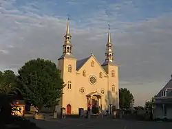
The present-day church, a historical-registered building, was built from 1754 to 1767. Interrupted during construction by the Seven Years' War (1756–1763), it is one of the last buildings to be constructed under the French regime. The church has a facade and two towers, a baroque interior, a neoclassical reredos, and two tiers of openings on the bell tower, a presbytery (designed by architect Charles Baillargé in 1849) featuring five neatly lined dormer windows. A cemetery encircles the square, leading to the river below.
The Place de l'Église square is crowned with old wells dating back to 1799. Vieux Chemin street was built along the same geographical line as that Chemin-du-Roy, the first road linking Montreal and Quebec City in the 18th century. Wooden and stone homes dot the narrow and shaded street that borders the cape. The quay is on the Saint Lawrence River.
In 1759 following the defeat of the French at the Battle of the Plains of Abraham during the Seven Years' War, the commander of the French forces, Chevalier de Lévis, ordered the construction of Fort Jacques-Cartier at the mouth of the Jacques-Cartier River[4] from materials originally destined for the construction of a church. The following year, using the fort as a logistics base, Lévis attempted unsuccessfully with 7,000 men to recapture Quebec City from the British. The British captured the fort in September 1760 and kept a garrison there until 1763 after which they abandoned it. Virtually nothing remains of the fort aside from archaeological remains,[4] which is also situated on private land inaccessible to the public on the 'Plateau Jacques-Cartier' district of the municipality. Close by, is the Allsopp House (late 18th century), an old seigneurial manor named after the Allsopp family, now a private property registered as a historical building.
The founder of the Congregation of the Sisters of Bon Pasteur, Marie Fitzbach, lived in Cap-Santé from 1826–1840. Gérard Morisset, architect and art historian, was also a resident, and designed the interiors of many of the region's churches.
Demographics
Population trend:[5]
- Population in 2011: 2,996 (2006 to 2011 population change: 12.4%)
- Population in 2006: 2,666
- Population in 2001: 2,571
- Population in 1996: 2,615
- Population in 1991: 2,563
Private dwellings occupied by usual residents: 1,246 (total dwellings: 1,327)
Mother tongue:
- English as first language: 2.7%
- French as first language: 96.0%
- English and French as first language: 0%
- Other as first language: 1.3%
Citations
- Reference number 366751 of the Commission de toponymie du Québec (in French)
- Ministère des Affaires municipales, des Régions et de l'Occupation du territoire - Répertoire des municipalités: Cap-Santé
- Statistics Canada 2011 Census - Cap-Santé census profile
- Chartrand, 2008, pp. 23–24
- Statistics Canada: 1996, 2001, 2006, 2011 census
References
- Chartrand, René (2008). The Forts of New France in Northeast America 1600–1763. Oxford, UK: Osprey Publishing. ISBN 978-1-846-03255-4.
External links
 Media related to Cap-Santé at Wikimedia Commons
- Town of Cap-Santé website
Adjacent Municipal Subdivisions | |
|---|---|
| Cities & towns | |
|---|---|
| Municipalities | |
| Parishes | |
| Unorganized territories | |
| |
| Authority control |
|---|
