Saint-André-de-Kamouraska
Saint-André-de-Kamouraska is a municipality in the Canadian province of Quebec, located in the Kamouraska Regional County Municipality.
Saint-André-de-Kamouraska
Saint-André | |
|---|---|
 | |
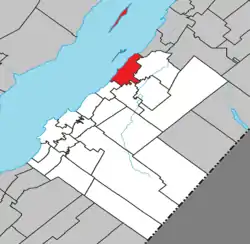 Location within Kamouraska RCM | |
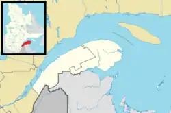 Saint-André Location in eastern Quebec | |
| Coordinates: 47°41′N 69°44′W[1] | |
| Country | |
| Province | |
| Region | Bas-Saint-Laurent |
| RCM | Kamouraska |
| Constituted | February 14, 1987 |
| Government | |
| • Mayor | Gervais Darisse |
| • Federal riding | Montmagny—L'Islet—Kamouraska—Rivière-du-Loup |
| • Prov. riding | Côte-du-Sud |
| Area | |
| • Total | 70.60 km2 (27.26 sq mi) |
| • Land | 70.74 km2 (27.31 sq mi) |
| There is an apparent contradiction between two authoritative sources | |
| Population | |
| • Total | 651 |
| • Density | 9.2/km2 (24/sq mi) |
| • Pop 2006-2011 | |
| • Dwellings | 272 |
| Time zone | UTC−5 (EST) |
| • Summer (DST) | UTC−4 (EDT) |
| Postal code(s) | G0L 2H0 |
| Area code(s) | 418 and 581 |
| Highways | |
| Website | www.standre dekamouraska.ca |
Geography
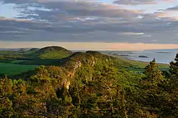
Landscape near Saint Lawrence River in Saint-André
Saint-André is located on the southern shoreline of the Saint Lawrence River along with several islands belonging to the municipality situated offshore to the north.
Communities
The following locations reside within the municipality's boundaries:[1]
- Saint-André (47°40′33″N 69°43′29″W)
- Saint-André-Station (47°37′49″N 69°41′09″W) – a hamlet in the southeast part of the municipality
Lakes and rivers
The following waterways pass through or are situated within the municipality's boundaries:[1]
- Rivière des Caps (Mouth:47°43′21″N 69°40′35″W)
- Rivière Fouquette (Mouth:47°42′04″N 69°42′09″W)
Municipal council
- Mayor: Gervais Darisse
See also
References
External links
 Media related to Saint-André-de-Kamouraska at Wikimedia Commons
Adjacent Municipal Subdivisions | |
|---|---|
| Cities & Towns | |
|---|---|
| Municipalities | |
| Parishes | |
| Unorganized territories | |
| |
| Authority control |
|---|
This article is issued from Wikipedia. The text is licensed under Creative Commons - Attribution - Sharealike. Additional terms may apply for the media files.