Saint-Gervais–Vallorcine railway
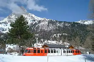
The Saint-Gervais–Vallorcine railway (French: Ligne de Saint-Gervais-les-Bains-Le Fayet à Vallorcine), also known as the Saint-Gervais–Vallorcine Line, is a single-track 36.5 km (22.7 mi) long metre gauge railway in France connecting the SNCF's Saint-Gervais-les-Bains-Le Fayet station with Vallorcine and the border with Switzerland (Le Châtelard)[2] through Chamonix. Opened in 1901 by the Chemins de fer de Paris à Lyon et à la Méditerranée, it is part of the main SNCF network as far as Vallorcine. To Le Châtelard (3 km or 1.86 mi) is run by the Swiss company TMR, which also operates the Martigny–Châtelard railway.
| Saint-Gervais–Vallorcine railway | |||||||||||||||||||||||||||||||||||||||||||||||||||||||||||||||||||||||||||||||||||||||||||||||||||||||||||||||||||||||||||||||||||||||||||||||||||||||||||||||||||||||||||||||||||||||||||||||||||||||||||||||||||||||||||||||||||||||||||||||||||||||||||||||||||||||||||||||||||||||||||||||||||||||||||||||||||||||||||||||||||||||||||||||||||||||||||||||||||||||||||||||||||||||||||||||||||||||||||||||||||||||||||||||||||||||||||||||||||||||||||||
|---|---|---|---|---|---|---|---|---|---|---|---|---|---|---|---|---|---|---|---|---|---|---|---|---|---|---|---|---|---|---|---|---|---|---|---|---|---|---|---|---|---|---|---|---|---|---|---|---|---|---|---|---|---|---|---|---|---|---|---|---|---|---|---|---|---|---|---|---|---|---|---|---|---|---|---|---|---|---|---|---|---|---|---|---|---|---|---|---|---|---|---|---|---|---|---|---|---|---|---|---|---|---|---|---|---|---|---|---|---|---|---|---|---|---|---|---|---|---|---|---|---|---|---|---|---|---|---|---|---|---|---|---|---|---|---|---|---|---|---|---|---|---|---|---|---|---|---|---|---|---|---|---|---|---|---|---|---|---|---|---|---|---|---|---|---|---|---|---|---|---|---|---|---|---|---|---|---|---|---|---|---|---|---|---|---|---|---|---|---|---|---|---|---|---|---|---|---|---|---|---|---|---|---|---|---|---|---|---|---|---|---|---|---|---|---|---|---|---|---|---|---|---|---|---|---|---|---|---|---|---|---|---|---|---|---|---|---|---|---|---|---|---|---|---|---|---|---|---|---|---|---|---|---|---|---|---|---|---|---|---|---|---|---|---|---|---|---|---|---|---|---|---|---|---|---|---|---|---|---|---|---|---|---|---|---|---|---|---|---|---|---|---|---|---|---|---|---|---|---|---|---|---|---|---|---|---|---|---|---|---|---|---|---|---|---|---|---|---|---|---|---|---|---|---|---|---|---|---|---|---|---|---|---|---|---|---|---|---|---|---|---|---|---|---|---|---|---|---|---|---|---|---|---|---|---|---|---|---|---|---|---|---|---|---|---|---|---|---|---|---|---|---|---|---|---|---|---|---|---|---|---|---|---|---|---|---|---|---|---|---|---|---|---|---|---|---|---|---|---|---|---|---|---|---|---|---|---|---|---|---|---|---|---|---|---|---|---|---|---|---|---|---|---|---|---|---|---|---|---|---|---|---|---|---|---|---|---|---|---|---|---|---|---|---|---|
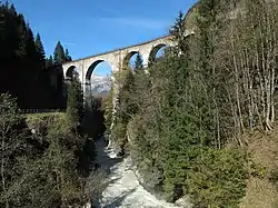 A view of the Sainte-Marie viaduct in 2014 | |||||||||||||||||||||||||||||||||||||||||||||||||||||||||||||||||||||||||||||||||||||||||||||||||||||||||||||||||||||||||||||||||||||||||||||||||||||||||||||||||||||||||||||||||||||||||||||||||||||||||||||||||||||||||||||||||||||||||||||||||||||||||||||||||||||||||||||||||||||||||||||||||||||||||||||||||||||||||||||||||||||||||||||||||||||||||||||||||||||||||||||||||||||||||||||||||||||||||||||||||||||||||||||||||||||||||||||||||||||||||||||
| Overview | |||||||||||||||||||||||||||||||||||||||||||||||||||||||||||||||||||||||||||||||||||||||||||||||||||||||||||||||||||||||||||||||||||||||||||||||||||||||||||||||||||||||||||||||||||||||||||||||||||||||||||||||||||||||||||||||||||||||||||||||||||||||||||||||||||||||||||||||||||||||||||||||||||||||||||||||||||||||||||||||||||||||||||||||||||||||||||||||||||||||||||||||||||||||||||||||||||||||||||||||||||||||||||||||||||||||||||||||||||||||||||||
| Locale | Haute-Savoie | ||||||||||||||||||||||||||||||||||||||||||||||||||||||||||||||||||||||||||||||||||||||||||||||||||||||||||||||||||||||||||||||||||||||||||||||||||||||||||||||||||||||||||||||||||||||||||||||||||||||||||||||||||||||||||||||||||||||||||||||||||||||||||||||||||||||||||||||||||||||||||||||||||||||||||||||||||||||||||||||||||||||||||||||||||||||||||||||||||||||||||||||||||||||||||||||||||||||||||||||||||||||||||||||||||||||||||||||||||||||||||||
| Termini | Saint-Gervais-les-Bains-Le Fayet Vallorcine | ||||||||||||||||||||||||||||||||||||||||||||||||||||||||||||||||||||||||||||||||||||||||||||||||||||||||||||||||||||||||||||||||||||||||||||||||||||||||||||||||||||||||||||||||||||||||||||||||||||||||||||||||||||||||||||||||||||||||||||||||||||||||||||||||||||||||||||||||||||||||||||||||||||||||||||||||||||||||||||||||||||||||||||||||||||||||||||||||||||||||||||||||||||||||||||||||||||||||||||||||||||||||||||||||||||||||||||||||||||||||||||
| Technical | |||||||||||||||||||||||||||||||||||||||||||||||||||||||||||||||||||||||||||||||||||||||||||||||||||||||||||||||||||||||||||||||||||||||||||||||||||||||||||||||||||||||||||||||||||||||||||||||||||||||||||||||||||||||||||||||||||||||||||||||||||||||||||||||||||||||||||||||||||||||||||||||||||||||||||||||||||||||||||||||||||||||||||||||||||||||||||||||||||||||||||||||||||||||||||||||||||||||||||||||||||||||||||||||||||||||||||||||||||||||||||||
| Rack system | None | ||||||||||||||||||||||||||||||||||||||||||||||||||||||||||||||||||||||||||||||||||||||||||||||||||||||||||||||||||||||||||||||||||||||||||||||||||||||||||||||||||||||||||||||||||||||||||||||||||||||||||||||||||||||||||||||||||||||||||||||||||||||||||||||||||||||||||||||||||||||||||||||||||||||||||||||||||||||||||||||||||||||||||||||||||||||||||||||||||||||||||||||||||||||||||||||||||||||||||||||||||||||||||||||||||||||||||||||||||||||||||||
| Track gauge | 1,000 mm (3 ft 3 3⁄8 in) | ||||||||||||||||||||||||||||||||||||||||||||||||||||||||||||||||||||||||||||||||||||||||||||||||||||||||||||||||||||||||||||||||||||||||||||||||||||||||||||||||||||||||||||||||||||||||||||||||||||||||||||||||||||||||||||||||||||||||||||||||||||||||||||||||||||||||||||||||||||||||||||||||||||||||||||||||||||||||||||||||||||||||||||||||||||||||||||||||||||||||||||||||||||||||||||||||||||||||||||||||||||||||||||||||||||||||||||||||||||||||||||
| Electrification | 850 V, DC top contact third rail | ||||||||||||||||||||||||||||||||||||||||||||||||||||||||||||||||||||||||||||||||||||||||||||||||||||||||||||||||||||||||||||||||||||||||||||||||||||||||||||||||||||||||||||||||||||||||||||||||||||||||||||||||||||||||||||||||||||||||||||||||||||||||||||||||||||||||||||||||||||||||||||||||||||||||||||||||||||||||||||||||||||||||||||||||||||||||||||||||||||||||||||||||||||||||||||||||||||||||||||||||||||||||||||||||||||||||||||||||||||||||||||
| Highest elevation | 1,365 m (4,478 ft) | ||||||||||||||||||||||||||||||||||||||||||||||||||||||||||||||||||||||||||||||||||||||||||||||||||||||||||||||||||||||||||||||||||||||||||||||||||||||||||||||||||||||||||||||||||||||||||||||||||||||||||||||||||||||||||||||||||||||||||||||||||||||||||||||||||||||||||||||||||||||||||||||||||||||||||||||||||||||||||||||||||||||||||||||||||||||||||||||||||||||||||||||||||||||||||||||||||||||||||||||||||||||||||||||||||||||||||||||||||||||||||||
| Maximum incline | 9% | ||||||||||||||||||||||||||||||||||||||||||||||||||||||||||||||||||||||||||||||||||||||||||||||||||||||||||||||||||||||||||||||||||||||||||||||||||||||||||||||||||||||||||||||||||||||||||||||||||||||||||||||||||||||||||||||||||||||||||||||||||||||||||||||||||||||||||||||||||||||||||||||||||||||||||||||||||||||||||||||||||||||||||||||||||||||||||||||||||||||||||||||||||||||||||||||||||||||||||||||||||||||||||||||||||||||||||||||||||||||||||||
| |||||||||||||||||||||||||||||||||||||||||||||||||||||||||||||||||||||||||||||||||||||||||||||||||||||||||||||||||||||||||||||||||||||||||||||||||||||||||||||||||||||||||||||||||||||||||||||||||||||||||||||||||||||||||||||||||||||||||||||||||||||||||||||||||||||||||||||||||||||||||||||||||||||||||||||||||||||||||||||||||||||||||||||||||||||||||||||||||||||||||||||||||||||||||||||||||||||||||||||||||||||||||||||||||||||||||||||||||||||||||||||
Connections
- At Saint-Gervais-les-Bains Le Fayet, with the standard gauge SNCF line from Aix-les-Bains via Annecy and la Roche-sur-Foron (including TGVs from Paris in the winter); and the Mont Blanc Tramway (TMB) rack railway.
- At Chamonix, with the Montenvers Railway, a rack railway.
- In Switzerland, at Le Châtelard, with the Martigny-Châtelard rack railway, which continues to Martigny where it connects with the Lausanne–Brig line of the CFF.
Technical information
- Track gauge: 1,000 mm (3 ft 3 3⁄8 in).
- Profile: uphill from the Saint-Gervais-Le Fayet (altitude: 580.95 m or 1,906.0 ft) to the col des Montets tunnel (altitude 1,365 m or 4,478 ft) then downhill to the border (altitude 1,100 m or 3,609 ft). The steepest grade, between Servoz and les Houches is 9% over 2,000 m (6,562 ft), a record for an adhesion railway. On the steepest sections (4% and more), it had a central rail for braking (and keeping trains immobile in case of electric black-outs), through jaws gripping the rail; it was removed around 1980.
- Electrification through top-contact third rail at 850 V (580 V originally) direct current.
- Main structures:
- Three viaducts, including the Sainte-Marie viaduct in the Houches over the Arve
- Several anti-avalanche galleries
- Col des Montets tunnel, 1,883 m (6,178 ft) long.
- Control: A command post, named PC Éclair (ECLAIR, or “lightning”, standing for Exploitation Centralisée des Lignes Assistée par Informatique et Radio, which translates to Centralised Control of the Lines Assisted by Computers and Radio), installed in 1991 at Saint-Gervais station, allows centralised control with the help of radio and computers.
Rolling stock
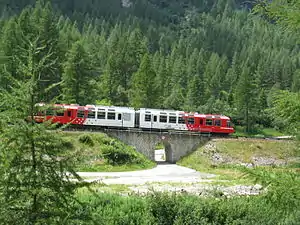
- Three Z 850 electric multiple units (EMUs) made by Stadler. Three additional trainsets were slated to arrive before 2008.
- Five Z 800 105-seat EMUs, delivered in 1997 by ADTranz and Vevey Technologies in a joint purchase with the Martigny-Châtelard. This 1000 kW stock, composed of two motor cars, can run at 70 km/h (43.5 mph); it is rack and pinion equipped, and has pantographs in addition to 3rd rail equipment, so that it run to Martigny.
- Eight Z 600 EMUs and four additional trailers (some out of service), used in busy periods.
- Snowploughs:
- Z 691 (electric)
- Beilhack CN4 (diesel)
- The original Z 200 motor cars have been retired.
- Service wagons: Flats (U 20201 - U 20203) and ballast-carrying (U 20204 and U 20205 (?)).
Activity
This line carries about 500,000 passengers per year, with wide variation: from 500 people per day in the least busy periods up to 10,000 per day in summer and 2500 per day in winter for the ski season. The customer base is quite diverse, from international travellers connecting with the TGVs, to local transportation, most notably for schoolchildren. It is a tourist line and a public service at the same time.
Through trains between Saint-Gervais and Martigny run under the “Mont-Blanc Express” brand.
Since 2005 travel has been free between Servoz and Vallorcine for those with a Chamonix residency card and for valley inhabitants.
History
- 1886: Granting of the concession for the Cluses-Chamonix line to the PLM (first concession for a general interest electric line in France)
- July 3, 1893: Authorisation for the PLM to build the Saint-Gervais to Chamonix section as metre gauge
- June 1899: Start of works on the first section
- July 25, 1901: Opening to Chamonix, 19 km (official opening on July 12)
- July 25, 1906: Extension to Argentière
- November 1, 1907: Boring of the col des Montets tunnel
- July 1, 1908: Junction with the Martigny-Châtelard
- 1958: Introduction of Z 600 EMUs
- 1997: Introduction of Z 800 EMUs
- 2006: Introduction of Z 850 EMUs; increase in frequency between Argentière and Vallorcine
Stations
- Saint-Gervais-les-Bains-Le Fayet
- Chedde
- Servoz
- Vaudagne (request stop)
- Viaduc Sainte Marie (request stop)
- Les Houches
- Taconnaz (request stop)
- Les Bossons
- Les Pélerins
- Les Moussoux (request stop)
- Aiguille du Midi
- Chamonix Mont-Blanc
- Les Praz
- Les Tines
- La Joux (request stop)
- Argentière
- Montroc-le Planet
- Le Buet
- Vallorcine
- Le Châtelard-Frontière
References
- Eisenbahnatlas Schweiz. Cologne: Schweers + Wall. 2012. p. 54. ISBN 978-3-89494-130-7.
- Le Châtelard Archived 2009-05-06 at the Wayback Machine
External links
| Wikimedia Commons has media related to Saint-Gervais-Vallorcine Line. |
- Train du Mont-Blanc, dedicated to the line (in French)
- Photos-trains (in French) has pictures of rolling stock