France–Switzerland border
The French–Swiss border is 572 km (355 mi) long.[1][2] Its current path is mostly the product of the Congress of Vienna of 1815, with the accession of Geneva, Neuchâtel, and Valais to the Swiss Confederation, but it has since been modified in detail, the last time being in 2002.[3]
| Wikimedia Commons has media related to Borders of France-Switzerland. |
Detailed path
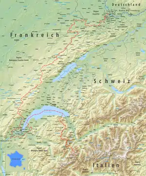
The tripoint where it meets the Swiss-German and Franco-German borders is on the river Rhine (at 47.5898°N 7.5890°E) at Basel. A monument has been built near it, known as the Dreiländereck.
The border runs south of Mulhouse Airport, and then towards the south-west, separating the villages of Schönenbuch (Switzerland), Neuwiller (France), Leymen (France), and Rodersdorf (Switzerland). It then enters the Jura chain, rising above 800 meters altitude before meeting the La Lucelle river at 460 m, between Roggenburg, Basel-Country and Kiffis (France). It follows the Lucelle as far as Lucelle municipality, running across the grounds of Lucelle Abbey. It then turns north to include the Swiss canton of Jura, and crosses the Doubs river at Brémoncourt, to include the Clos du Doubs region in Switzerland. It meets the Doubs a second time further upstream, at 481 m, and from here follows the winding course of the river as far as the Lac des Brenets, north of Le Locle, at 756 m.
After passing the Col des Roches at 920 m, the border runs in a south-westerly direction, generally following the Jura ridge, reaching an altitude of 1288 m (Le Meix Musy). It turns towards the south to include Pontarlier in France, and again to the south-west to include Vallorbe and the Lac de Joux in Switzerland. Here it reaches an altitude of 1377 m, before crossing the Orbe river upstream of Bois-d'Amont.
South of Les Rousses it turns to the south and then south-east, running towards Lake Geneva, rising to 1400 m at 46.4113°N 6.0866°E, passing south of La Dôle peak. Some 3 km before reaching the lake, the border runs parallel to the shore of Lake Geneva, forming the strip of land ceded by France to Switzerland in 1815 as the canton of Geneva, so that the city of Geneva has a land bridge connecting it to the rest of Switzerland. The border now encircles the city of Geneva. West of the city, it follows the Rhone for some 6–km, until the westernmost point of Switzerland, at 46.1324°N 5.9559°E. The border passes between Geneva and Anemasse, heading east towards Saint-Cergues, and it finally finds Lake Geneva from the south, at Hermance.
The border runs along the center of the lake, but makes landfall before reaching the mouth of the Rhone, at St-Gingolph. From here, the border runs south and south-east into the High Alps, forming the western border of the Valais. It passes Les Cornettes de Bise (2431 m), Dent de Barme (2759 m), Petit Ruan (2846 m), Pointe des Rosses (2965 m), Pointe de la Fenive (2838 m), and Le Cheval Blanc (2830 m), placing Lac du Vieux Émosson in Switzerland. From Grand Perrond (2672 m), the border descends to 1130 m, crossing the Martigny-Chamonix road, before ascending to Les Grandes Otanes (2656 m), Aiguille du Tour (3541 m), Aiguille d'Argentiere (3898 m), Tour Noir (3837 m) and finally to the tripoint with the French-Italian and Swiss-Italian borders, at a point just west of Mont Dolent, 45.9227°N 7.0441°E, and at 3,752 metres (12,310 ft) altitude.
Border controls

.jpg.webp)
Since Switzerland's accession to the Schengen Area in 2008, there have been no permanent passport controls along this border, although there can be customs controls.
There are two airports near the border which have both Swiss and French passport and customs controls, and passengers can choose one of them. These are:
- the EuroAirport Basel Mulhouse Freiburg which is located in France, but passengers can go to Switzerland without going through French border controls, and
- the Geneva Airport which is located in Switzerland, but passengers can go to France without going through Swiss border controls.
Road customs control stations
[4] From northeast to south
- Basel/St. Louis-Autobahn (E25/A35/A3)
- Boncourt/Delle-Autoroute (E27/N1019/A16)
- Col France (D461/20)
- Vallorbe (E23/N57/9)
- Bardonnex (A41/1)
- Thônex-Vallard (A411)
- St-Gingolph (D1005/21)
There are several other roads which cross the border, but without customs controls.
Railway and tram lines over the border
Several railway lines cross the border.
Also some tram lines cross the border.
- The Basel tram line 3 was in 2017 extended to Saint-Louis in France
- The Basel tram line 10 twice with one station in France, Leymen
See also
References
- "Archived copy". Archived from the original on 2014-10-20. Retrieved 2014-11-27.CS1 maint: archived copy as title (link)
- http://cnig.gouv.fr/?page_id=8642
- "Traité international". Swiss Federal Department of Foreign Affairs. Retrieved January 24, 2013.; minor corrections resulting in the exchange of a total of 1,578 square meters of territory.
- http://www.pwebapps.ezv.admin.ch/apps/dst/?lang=1