Aosta Valley
The Aosta Valley (Italian: Valle d'Aosta [ˈvalle daˈɔsta] (official) or Val d'Aosta (usual); French: Vallée d'Aoste; Francoprovençal: Val d'Outa (usual); Walser: Augschtalann or Ougstalland; Piedmontese: Val d'Osta) is a mountainous autonomous region[6] in northwestern Italy. It is bordered by Auvergne-Rhône-Alpes, France, to the west, Valais, Switzerland, to the north, and by Piedmont, Italy, to the south and east. The regional capital is Aosta.
Aosta Valley
| |
|---|---|
 Coat of arms | |
| Anthem: Montagnes Valdôtaines | |
 | |
| Coordinates: 45°44′49″N 7°26′21″E | |
| Country | |
| Capital | Aosta |
| Government | |
| • President | Erik Lavévaz (UV) |
| Area | |
| • Total | 3,263 km2 (1,260 sq mi) |
| Population (30-10-2012) | |
| • Total | 126,933 |
| • Density | 39/km2 (100/sq mi) |
| • Official languages[1] | Italian French |
| Demonym(s) | English: Aostan, Valdostan or Valdotainian[2] Italian: Valdostano (man) Italian: Valdostana (woman) French: Valdôtain (man) French: Valdôtaine (woman) |
| Citizenship | |
| • Italian | 95% |
| Time zone | UTC+1 (CET) |
| • Summer (DST) | UTC+2 (CEST) |
| ISO 3166 code | IT-23 |
| GDP (nominal) | €4.9 billion (2018)[4] |
| GDP per capita | €38,900 (2018)[4] |
| HDI (2018) | 0.877[5] very high · 14th of 21 |
| NUTS Region | ITC |
| Website | Regione.vda.it |

Covering an area of 3,263 km2 (1,260 sq mi) and with a population of about 128,000 it is the smallest, least populous, and least densely populated region of Italy. It is the only Italian region that is not subdivided into provinces (the province of Aosta was dissolved in 1945).[7] Provincial administrative functions are provided by the regional government. The region is divided into 74 comuni (French: communes).
Italian and French are the official languages,[1] though the native population also speak Valdôtain, a dialect of Franco-Provençal. Italian is spoken as a mother tongue by 77.29% of population, Valdôtain by 17.91%, and French by 1.25%. In 2009, reportedly 50.53% of the population could speak all three languages.[8]
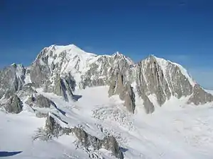
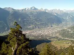
Geography
.jpg.webp)
The Aosta Valley is an Alpine valley which with its tributary valleys includes the Italian slopes of Mont Blanc, Monte Rosa, Gran Paradiso and the Matterhorn; its highest peak is Mont Blanc (4,810 m or 15,780 ft). This makes it the highest region in Italy by list of Italian regions by highest point.
Climate
The valleys, usually above 1,600 m (5,200 ft), annually have a Cold Continental Climate (Dfc). In this climate the snow season is very long, as long as 8 or 9 months at the highest points. During the summer, mist occurs almost every day. These areas are the wettest in the western Alps. Temperatures are low, between −7 °C (19 °F) and −3 °C (27 °F) in January, and in July between 20 °C (68 °F) and 35 °C (95 °F). In this area is the town of Rhêmes-Notre-Dame,[9] which may be the coldest town in the Western Alps and where the winter average temperature is around −7 °C (19 °F).
Areas between 2,000 and 3,500 m (6,600 and 11,500 ft) usually have a Tundra Climate (ET), where every month has an average temperature below 10 °C (50 °F). This climate may be a kind of more severe Cold Oceanic Climate, with a low summer average but mild winters, sometimes above −3 °C (27 °F), especially near lakes, or a more severe Cold Continental Climate, with a very low winter average. Temperature averages in Plateau Rosa, at 3,400 m (11,200 ft) high, are −11.6 °C (11.1 °F) in January and 1.4 °C (34.5 °F) in July. It is the coldest place in Italy where the climate is verifiable.[10]
In the past, above 3,500 m (11,500 ft), all months had an average temperature below freezing, with a Perpetual Frost Climate (EF). In recent years though there was a rise in temperatures. See as an example the data for Plateau Rosa.[10]
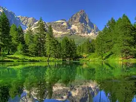 Bleu Lake[11] and the Matterhorn
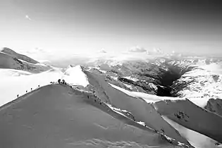
History
The first inhabitants of the Aosta Valley were Celts and Ligures, whose language heritage remains in some local placenames. Rome conquered the region from the local Salassi around 25 BC and founded Augusta Prætoria Salassorum (modern-day Aosta) to secure the strategic mountain passes, and they went on to build bridges and roads through the mountains. Thus, the name Valle d'Aosta literally means "Valley of Augustus".[12]
In 1031–1032, Humbert I of Savoy, the founder of the House of Savoy, received the title Count of Aosta from Emperor Conrad II of the Franconian line and built himself a commanding fortification at Bard. Saint Anselm of Canterbury was born in Aosta in 1033 or 1034. The region was divided among strongly fortified castles, and in 1191, Thomas I of Savoy found it necessary to grant to the communes a Charte des franchises ("Charter of Liberties") which preserved autonomy—rights that were fiercely defended until 1770, when they were revoked in order to tie Aosta more closely to Piedmont, but which were again demanded during post-Napoleonic times. In the mid-13th century, Emperor Frederick II made the County of Aosta a duchy (see Duke of Aosta), and its arms charged with a lion rampant were carried in the Savoy arms until the reunification of Italy in 1870.[14]
The region remained part of Savoy lands, with the exceptions of French occupations from 1539 to 1563, later in 1691, then between 1704 and 1706. It was also ruled by the First French Empire between 1800 and 1814. During French rule, it was part of Aoste arrondissement in Doire department.[15] As part of the Kingdom of Sardinia, it joined the new Kingdom of Italy in 1861.
French forces briefly controlled the area at the end of World War II, but withdrew under British and American pressure.[16] The region gained special autonomous status after the end of World War II; the province of Aosta ceased to exist in 1945.[7]
Government and politics
For more than 20 years the valley has been dominated by autonomist regional parties. The last regional election was held in September 2020. On 15 October 2020, Erik Lavévaz of the Valdostan Union was elected president by the region's cabinet.
Demographics
.jpg.webp)
| Year | Pop. | ±% |
|---|---|---|
| 1861 | 81,884 | — |
| 1871 | 81,260 | −0.8% |
| 1881 | 85,007 | +4.6% |
| 1901 | 83,529 | −1.7% |
| 1911 | 80,680 | −3.4% |
| 1921 | 82,769 | +2.6% |
| 1931 | 83,479 | +0.9% |
| 1936 | 83,455 | −0.0% |
| 1951 | 94,140 | +12.8% |
| 1961 | 100,959 | +7.2% |
| 1971 | 109,150 | +8.1% |
| 1981 | 112,353 | +2.9% |
| 1991 | 115,938 | +3.2% |
| 2001 | 119,548 | +3.1% |
| 2011 | 128,000 | +7.1% |
| 2017 | 126,883 | −0.9% |
| Source: ISTAT 2001 | ||
The population density of Aosta Valley is by far the lowest of the Italian regions. In 2008, 38.9 inhabitants per km2 were registered in the region, whereas the average national figure was 198.8, though the region has extensive uninhabitable areas of mountain and glacier, with a substantial part of the population living in the central valley. Migration from tributary valleys has now been stemmed by generous regional support for agriculture and tourist development.
Negative natural population growth since 1976 has been more than offset by immigration. The region has one of Italy's lowest birth rates, with a rising average age. This, too, is partly compensated by immigration, since most immigrants arriving in the region are younger people working in the tourist industry. Between 1991 and 2001, the population of Aosta Valley grew by 3.1%, which is the highest growth among the Italian regions. With a negative natural population growth, this is due exclusively to positive net migration.[3] Between 2001 and 2011, the population of Aosta Valley grew by a further 7.07%. As of 2006, the Italian National Institute of Statistics (ISTAT) estimated that 4,976 foreign-born immigrants live in Aosta Valley, equal to 4.0% of the total regional population.
The Valdôtain population and their language dialects have been the subject of some sociological research.[17]
Culture
Languages
The Aosta Valley was the first government authority to adopt Modern French as the official language in 1536, three years before France itself.[18] In modern times, Italian and French are the region's official languages[1] and are used for the regional government's acts and laws, though Italian is much more widely spoken in everyday life, and French is mostly spoken in cultural life. Education is conducted evenly in French and Italian,[1] so that anyone who has gone to school in the Aosta Valley can speak French to at least a medium-high level.[19]
The regional language, known as patoué valdotèn or simply patoué (patois valdostano in Italian, patois valdôtain in French), is a dialectal variety of Franco-Provençal. It is spoken as a native and second language by 68,000 residents, or about 58% of the population according to a sociolinguistic survey carried out by the Fondation Émile Chanoux in 2001.[20]
The survey found out that the Italian language was spoken as a mother tongue by 77.29% of respondents, Franco-Provençal by 17.91%, while French by 1.25%. The residents of the villages of Gressoney-Saint-Jean, Gressoney-La-Trinité and Issime, in the Lys Valley, speak two dialects of Walser German, Titsch and Töitschu, respectively.[19] According to the survey, Walser German was spoken as a mother tongue by 207 people, or 17.78%, in these three villages. Nevertheless, it was known to 56.38% of the population.[21]
Castles
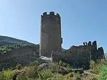
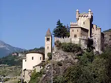
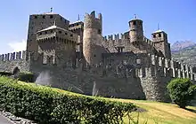
There are a numerous medieval castles and fortified houses in the Aosta Valley, including Châtel-Argent, Saint-Pierre Castle, Fénis Castle, Issogne Castle, Ussel Castle, Sarre Castle, Cly Castle, Verrès Castle, and Châtelard Castle.[23] Savoy Castle in Gressoney-Saint-Jean was conceived in the 19th century and completed in 1904.[23] Since 1990, it has also been home to the Savoy Castle Alpine Botanical Garden.
Cuisine
The cuisine of Aosta Valley is characterized by simplicity and revolves around "robust" ingredients such as potatoes, polenta; cheese and meat; and rye bread. Many of the dishes involve Fontina,[24] a cheese with PDO status, made from cow's milk that originates from the valley. It is found in dishes such as the soup à la vâpeuleunèntse[25] (Valpelline Soup). Other cheeses made in the region are Tomme de Gressoney[26] and Seras. Fromadzo (Valdôtain for cheese) has been produced locally since the 15th century and also has PDO status.[27]
Regional specialities, besides Fontina, are Motzetta (dried chamois meat), Vallée d'Aoste Lard d'Arnad[28] (a cured and brined fatback product with PDO designation), Vallée d'Aoste Jambon de Bosses[29] (a kind of ham, likewise with PDO designation), a dark bread made with rye, and honey.
Notable dishes include Carbonnade, similar to the Belgian dish of the same name consisting of salt-cured beef cooked with onions and red wine served with polenta; breaded veal cutlets called costolette; teuteuns,[30] salt-cured cow's udder that is cooked and sliced; and steak à la valdôtaine,[31] a steak with croûtons, ham and melted cheese.
Gallery
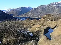 The prehistoric site near Chenal castle, Montjovet, rich in petroglyphs
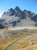 A view from refuge Albert Deffeyes, La Thuile
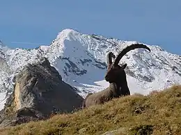
.jpg.webp)
See also
- Alps-Mediterranean Euroregion
- Roman Catholic Diocese of Aosta
- Elections in Aosta Valley
- Mont Blanc
- List of Presidents of Aosta Valley
- Arch of Augustus in Aosta
- Roman Theatre, Aosta
- Roman bridge Pont d'Aël
- 13th-century bridge of Grand Arvou
- Fort Bard—Museum of the Alps
- Mont Blanc Tunnel
- Gran Paradiso National Park
References
- "Statut spécial de la Vallee d'Aoste" (in French). Conseil régional de la Vallée d'Aoste. 2001. Retrieved 2015-10-25.
- Valdotanian Regional Election, 1963. Equ Press. ISBN 9786138249726.
- "Statistiche demografiche ISTAT" (in Italian). Demo.istat.it. Retrieved 2010-04-22.
- "Regional GDP per capita ranged from 30% to 263% of the EU average in 2018" (Press release). ec.europa.eu. Retrieved 1 September 2020.
- "Sub-national HDI - Area Database - Global Data Lab". hdi.globaldatalab.org. Retrieved 2018-09-13.
- "Le Statut spécial de la Vallée d'Aoste". 1948. Retrieved 2017-07-10. Articles 1 and 48b of the constitutional law officially assert the region's autonomy.
- "Italian Parliament - VI Commission document 2000-07-18 (in Italian)" (PDF).
- Decime, R.; Vernetto, G., eds. (2009). Profil de la politique linguistique de la Vallée d'Aoste (in French). Le Château. p. 20.
- "Guida alla consultazione del bollettino meteorologico della Regione Autonoma Valle d'Aosta con elementi di meteorologia alpina" (in Italian). Valle d'Aosta Official Website.
- "Tempo in atto su Plateau Rosa". meteoam.it. meteoam.it. 2012. Retrieved 2020-01-21.
- Lovevda.it
- Poling, Dean (October 12, 2009). "What does Valdosta mean?". Valdosta Daily Times. Archived from the original on July 19, 2012. Retrieved 2013-02-21.
- "ESO Astronomy Camp for Secondary School Students". eso.org. 13 May 2013. Retrieved 15 May 2013.
- François Velde (2000). "Heraldry in the House of Savoia". Heraldica. Retrieved 2010-04-22.
- Almanach Impérial an bissextil MDCCCXII, pp. 392–393, accessed in Gallica 18 February 2015 (in French)
- Harris, Charles Reginald Schiller (1957). Allied military administration of Italy, 1943-1945. H. M. Stationery Office. pp. 318–20.
- Saint-Blancat, Chantal (1984). "The Effect of Minority Group Vitality upon Its Sociopsychological Behaviour and Strategies". Journal of Multilingual and Multicultural Development. 5 (6): 511–516. doi:10.1080/01434632.1984.9994177.
Cooper, Danielle Chavy (1987). "Voices from the Alps: Literature in Val d'Aoste Today". World Literature Today. 61 (1): 24–27. doi:10.2307/40142443. JSTOR 40142443. - Caniggia, Mauro; Poggianti, Luca (2012-10-25). "La Vallée d'Aoste: enclave francophone au sud-est du Mont Blanc" (in French). Zigzag magazine. Archived from the original on 2013-12-04. Retrieved 2013-11-28.
- AA. VV. "Une Vallée d'Aoste bilingue dans une Europe plurilingue". in French and Italian. Aoste: Fondation Emile Chanoux. Archived from the original on 2015-09-24. Retrieved 2015-04-07.
- "Sondaggio linguistico: Q 0301 Lingua materna - Qual è la sua lingua materna?". Fondation Émile Chanoux (in Italian). Archived from the original on 2017-12-21. Retrieved 2018-05-31.
- "Sondaggio Linguistico Comunità Walser". Fondation Émile Chanoux (in Italian). Archived from the original on 2018-08-24. Retrieved 2018-05-31.
- Aosta Valley Regional Museum of Natural Science museoscienze.it
- Massetti, E. "Aosta Valley Castles" n.d., accessed 15 March 2014.
- "Fontina". Valle D'Aosta Official Tourism Website. 2014. Retrieved 2015-10-23.
- "Seupa à la Vapelenentse (Valpelline Soup)". Valle D'Aosta Official Tourism Website. 2014. Retrieved 2015-10-23.
- "Gressoney toma cheese". Aosta Valley Official Tourism Website. 2014. Retrieved 2015-10-23.
- "Fromadzo cheese". Valle D'Aosta Official Tourism Website. 2014. Retrieved 2015-10-23.
- "Valleé d'Aoste Lard d'Arnad". Aosta Valley Official Tourism Website. 2014. Retrieved 2015-10-23.
- "Vallée d'Aoste Jambon de Bosses". Aosta Valley Official Tourism Website. 2014. Retrieved 2015-10-23.
- "The Teuteun". Valle D'Aosta Official Tourism Website. 2014. Retrieved 2015-10-23.
- "Steak Valdaostan style" (in Italian). Consorzio Produttori e Tutela Della Fontina DOP. Retrieved 2015-10-23.
- "D.O.C. Wine". Valle D'Aosta Official Tourism Website. 2014. Retrieved 2015-10-23.
Sources
- Cerutti, Augusta Vittoria. "Le Pays de la Doire et son peuple". Quart: éditeur Musumeci. Cite journal requires
|journal=(help) - Colliard, Lin (1976). "La culture valdôtaine au cours des siècles". Aoste. Cite journal requires
|journal=(help) - Henry, Joseph-Marie (1967). "Histoire de la Vallée d'Aoste". Aoste: Imprimerie Marguerettaz. Cite journal requires
|journal=(help) - Janin, Bernard (1976). "Le Val d'Aoste. Tradition et renouveau". Quart: éditeur Musumeci. Cite journal requires
|journal=(help) - Riccarand, Elio. "Storia della Valle d'Aosta contemporanea (1919-1945)". Aoste: Stylos Aoste. Cite journal requires
|journal=(help)
External links
| Wikivoyage has a travel guide for Aosta Valley. |
| Wikimedia Commons has media related to Aosta Valley. |
- Website of the Aosta Valley Regional Authority (in Italian and French)
- Castes and fortresses at mondimedievali.net (in Italian)
| Provinces and places |
|  |
|---|---|---|
| History | ||
| Politics and government |
| |
| Education and culture | ||
Categories | ||
| Authority control |
|---|