Salem, Wellington County
Salem is a compact rural community and unincorporated place in the incorporated township of Centre Wellington, Wellington County, in southwestern Ontario, Canada.[1][3][4]
Salem | |
|---|---|
Compact Rural Community | |
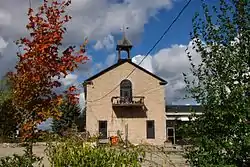 Original school house in Salem. | |
 Salem Location in southern Ontario | |
| Coordinates: 43°41′36″N 80°26′49″W[1] | |
| Country | Canada |
| Province | Ontario |
| County | Wellington County |
| Township | Centre Wellington |
| Elevation | 400 m (1,300 ft) |
| Time zone | UTC-5 (EST) |
| • Summer (DST) | UTC-4 (EDT) |
| Forward sortation area | N0G 1S0 |
| Area code(s) | 519, 226, 548 |
| NTS Map | 040P09 |
| GNBC Code | FDTDG |
Economy
Local business area in Salem is mainly found along and near Woolwich Street (County Road) and County Road 7 including:
- Esso gas station with convenience store
- Ontario Potato Board office
- Strata Gallery
- Mirage Limousine
- Salem Collision
- Deboer's Farm Equipment
- Burns Motorsports
- Artech Millwright
- Shantz Automotive
Transportation
Salem has two bridges that over Irvine Creek:
- Pratt truss bridge carrying Woolwich Street West: paved single lane in each direction with single sided sidewalk for pedestrians on northside
- Concrete beam bridge carried unpaved Washington Street: requiring traffic to yield as bridge too narrow to carry two way traffic has been closed
Wellington County Road 7 and Wellington County Road 10 (Woolwich Street West and Geddes Street) are then main primary roads connecting Salem with other communities. Most of the roads in Salem are gravel other than the two aforementioned county roads. Within Salem there is one traffic light at Woolwich and Wellington County Road 7 with all other intersections controlled by stop signs.
Education
Salem Public School is the only school situated in Salem and belongs to the Upper Grand District School Board. Secondary students needs to travel to Fergus, Ontario to attend Centre Wellington District High School.
The old Salem School House at 93 Woolwich Street West (Woolwich Street and Wellington County Road 7) is now home to Strata Gallery.[5]
The nearest Catholic school (within the Wellington Catholic District School Board) is St. Joseph Catholic School in Fergus. The closest Catholic high school is found in Guelph, Ontario.
Recreation
Recreation facilities located within Salem are Centre Wellington Ball Hockey Club and Veteran's Park.
Neighbourhoods
Most residents live along the areas along Irvine Creek and is known for its many historic stone houses. In recent years, Salem's size has grown due to an urban development on William Street, between Water Street and Victoria Street.
Places of worship
- Grand River Community Church - Evangelical Baptist
- Canadian Reformed Church of Elora
References
- "Salem". Geographical Names Data Base. Natural Resources Canada. Retrieved 2017-03-10.
- Elevation taken at geographic coordinates from Google Maps. Accessed 2017-03-10.
- Map 2 (PDF) (Map). 1 : 700,000. Official road map of Ontario. Ministry of Transportation of Ontario. 2015-01-01. Retrieved 2017-03-10.
- Restructured municipalities - Ontario map #6 (Map). Restructuring Maps of Ontario. Ontario Ministry of Municipal Affairs and Housing. 2006. Retrieved 2017-03-10.
- https://www.southwesternontario.ca/news-story/5989637-strata-gallery-relocates-now-open-in-salem-schoolhouse/
Places adjacent to Salem, Wellington County | ||||||||||
|---|---|---|---|---|---|---|---|---|---|---|
| ||||||||||