Wellington County, Ontario
Wellington County is a county located in Southwestern Ontario, Canada and is part of the Greater Golden Horseshoe. The County, made up of two towns and five townships, is predominantly rural in nature. However many of the residents in the southern part of the County commute to urban areas such as Guelph, Kitchener, Waterloo, Brampton, Mississauga, Toronto and Hamilton for employment. The northern part of the county (comprising Minto, Mapleton and Wellington North townships) is made up of mainly rural farming communities, except for a few larger towns such as Mount Forest and Arthur. According to the 2016 Census, the population of the County was 90,932.[3]
Wellington County | |
|---|---|
| County of Wellington | |
 Coat of arms | |
| Motto(s): Vision, Valour | |
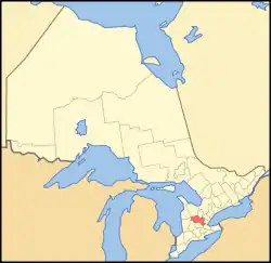 Location of Wellington County | |
| Coordinates: 43°45′N 80°24′W | |
| Country | |
| Province | |
| County seat | Guelph (independent) |
| Municipalities | |
| Government | |
| • Warden | Kelly Linton[1] |
| Area | |
| • Land | 2,573.26 km2 (993.54 sq mi) |
| Population (2016)[3] | |
| • Total | 90,932 |
| • Density | 35.3/km2 (91/sq mi) |
| Time zone | UTC-5 (EST) |
| • Summer (DST) | UTC-4 (EDT) |
| Website | www.county.wellington.on.ca/ |
In 2018, the Warden of the county was Kelly Linton (mayor of Centre Wellington) and there were 14 Councillors.[1] Police services are provided by the Ontario Provincial Police.[4] Schools are operated by the Upper Grand District School Board and by the Wellington Catholic District School Board.
Subdivisions
The County is made up of seven lower-tier municipalities (in order of population):
- Centre Wellington, Township of (population centre: Fergus, Elora, Belwood)
- Guelph/Eramosa, Township of (population centre: Rockwood)
- Wellington North, Township of (population centres: Mount Forest, Arthur)
- Erin, Town of (population centre: Erin)
- Mapleton, Township of (population centre: Drayton)
- Minto, Town of (population centres: Palmerston, Harriston)
- Puslinch, Township of (population centre: Aberfoyle)
The City of Guelph, although part of the Wellington census division, is a single-tier city, municipally independent of the County. The primary economy outside of the city consists of agriculture and aggregate mining.[5] The County is a major supplier of sand and gravel for the western part of the Greater Toronto Area.[6]
History
Evolution
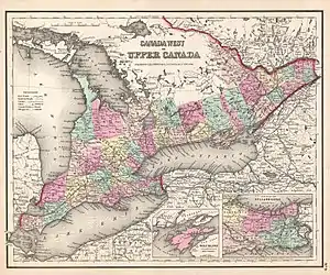
In 1837, by an Act of the Legislative Assembly of Upper Canada, the District of Wellington was formed and a court house and jail in the town of Guelph were authorized.[7] The District was named after England's Duke of Wellington and its territory formed the County of Waterloo for electoral purposes.[8] The limestone county courthouse and jail in the castellated style was built in 1842-44 and was subsequently expanded.[9]
In 1849, Wellington District was abolished, and Waterloo County remained for municipal and judicial purposes.[10] The territory of the Bruce Peninsula became part of Waterloo in 1849,[11] but was later withdrawn and transferred to Bruce County in 1851.[12]
In January 1852, Waterloo County became the United Counties of Wellington, Waterloo and Grey.[13] The new county of Waterloo was withdrawn in January 1853, and the remainder was renamed the United Counties of Wellington and Grey.[14]
In January 1854, the United Counties was dissolved, and Wellington and Grey were separate counties for all purposes.[15]
Guelph was incorporated as a City in 1879 and withdrawn from the County.[16] Amaranth, East Garafraxa, East Luther and Orangeville were transferred to Dufferin County during the period 1874-1882.[17][18][19][20]
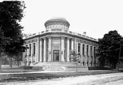
The Wellington County Jail (in Late Gothic Revival Style) and the Governor's Residence (in Georgian style) at 74 Woolwich Street were built in 1911; they were designated by the city for "historic and architectural value" and as a National Historic Site in 1983. The property is now an Ontario Court of Justice.[21]
Historic townships
By 1881, the County had settled into its present form, with the following townships and related towns and villages:
| Township | Area | Description | Community centres |
|---|---|---|---|
| Arthur | 64,494 acres (261 km²) | Opened in 1835, it was named after Arthur Wellesley, 1st Duke of Wellington | Arthur, Kenilworth and Mount Forest |
| Eramosa | 44,482 acres (180 km²) | Opened in 1821. The name is an attempt to render in English the Indian "un-ne-mo-sa", which means dog | Eden Mills and Rockwood |
| Erin | area 70,557 acres (286 km²) | Opened in 1820 | Erin, Hillsburgh, Mimosa |
| West Garafraxa | 46,950 acres (190 km²) | Opened in 1821. Name is believed to be from an Indian word meaning "the place of panthers." | Fergus (only partially in the township), Reading, Metz and Garafraxa |
| Guelph Township | 35,543 acres (144 km²) | Opened on April 23, 1827 by John Galt on behalf of the Canada Company | |
| West Luther | 49,830 acres (202 km²) | Opened in 1821 and named after the leader of the Reformation in Germany, Martin Luther. It was said that the surveyor, a Roman Catholic, having been embarrassed by the endless swamps he had encountered declared that this was "the meanest piece of country he had seen" and named it Luther for that reason | Monck, Stonywood, Damascus and Arthur |
| Maryborough | 56,728 acres (230 km²) | Opened in 1840 and named after a brother of the Duke of Wellington, Baron Maryborough | Drayton, Moorefield and Rothsay |
| Minto | 69,927 acres (283 km²) | Opened in 1840 and named after the Earl of Minto, a famous pro-consul in India. Settled mainly between 1861 and 1875 | Harriston, Palmerston, and Clifford |
| Nichol | 26,996 acres (109 km²) | One of the townships leased by Joseph Brant under power of attorney for the Indians of the Grand River region. The Township was granted to Hon. Thomas Clark on a lease of 999 years for 3,564, but the contract was modified by the Crown. The Township was opened for settlement in 1822. Named in honour of Col Robert Nichol of Norfolk who distinguished himself in the War of 1812 and latter in political battles | Elora, Fergus, Salem and Barnet |
| Peel | 74,525 acres (302 km²) | Opened in 1835 and named in honour of Sir Robert Peel. Settled mainly between 1850 and 1853 | Drayton, Glenallan, Goldstone and Alma |
| Pilkington | 28,983 acres (117 km²) | Named in honour of Lieutenant Robert Pilkington (later General Pilkington) who accompanied John Graves Simcoe to Upper Canada. Pilkington acquired 20,000 acres (80 km²) of land | Elora in Nichol Township |
| Puslinch | 58,291 acres (236 km²) | Named after Puslinch, Devon, Lady Colborne's home before her marriage | Aberfoyle |
In 1999, seven new municipalities (Townships) were created within Wellington County through amalgamation.[20]
From "poorhouse" to museum
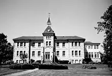
In 1877, the County opened the Wellington County House of Industry and Refuge, or Poorhouse as it was called, on Wellington Road 18 between Fergus and Elora. Over the years, approximately 1500 deserving poor, including those who were destitute, old and infirm or suffering from disabilities were housed here. The sixty bed house for inmates was surrounded by a 30-acre "industrial" farm with a barn for livestock that produced some of the food for the 70 residents and the staff and also provided work for them. Others worked in the House itself. According to a 2009 report by the Toronto Star, "pauperism was considered a moral failing that could be erased through order and hard work". A hospital was added in 1892. A nearby cemetery has 271 plots for those who died. In 1947 the House was converted into the Wellington County Home for the Aged and in 1975 the building reopened as the Wellington County Museum and Archives.[22][23][24]
A historic plaque was erected at the museum, indicating that the "government-supported poorhouse" was "the shelter of last resort for the homeless and destitute, who traded spartan accommodations for domestic or agricultural labour".[25]
Demographics
Historic population, for the County only, excluding Guelph, are as follows:
- 2016: 90,032 (5-year population growth: 4.9%)
- 2011: 86,672 (5-year population growth: 1.4%)
- 2006: 85,482 (5-year population growth: 5.3%)
- 2001: 81,143 (5-year population growth: 7.3%)
- 1996: 75,585
Figures below are for the Wellington census division, which combines Wellington County and the City of Guelph.[3]
- 2016 population: 222,726
- 2016 land area: 2,660.57 km2.
- 2016 population density: 83.7
- 2016 total number of private dwellings: 90,846
Community involvement and awards
In October 2008, the County of Wellington was named one of Canada's Top 100 Employers by Mediacorp Canada Inc. and featured in Maclean's newsmagazine.[26] Later that month, the County was recognized as one of Waterloo Area's Top Employers and featured in the Guelph Mercury newspaper.[27]
In 2014, the County of Wellington received Best Health and Wellness Strategy at the Canadian HR Awards. This award recognizes excellence in the area of corporate health and well-being.
in 2013 (Gold), and again in 2014 (Silver), The County of Wellington received Canada's Safest Employer in the Public Sector Award. Canada's Safest Employers Awards recognize organizations from all across Canada with outstanding accomplishments in promoting the health and safety of their workers.
In 2014 (Gold), and again in 2016 (Silver), The County of Wellington received Canada's Psychological Safety Award. Canada's Safest Employer Awards introduced a new Psychological Safety Award in 2014 to recognize organizations that are committed to employee mental health and are working towards implementing the National Standard for Psychological Health and Safety in the Workplace.
The County of Wellington in Ontario, Canada, embarked on the BR+E journey beginning in 2013. Two years later, the County has reaped significant rewards with the candle on the cake represented by two BREI awards at the BREI Annual Conference in 2014.
The County of Wellington proudly received the 2015 Employer of Distinction Award at an Award Ceremony presented by the Guelph and District Human Resources Professionals Association in Guelph.
In early 2018, Alma resident Jim deBock received the Ontario Medal for Good Citizenship for his extensive volunteer work.[28]
Travel Region
Wellington County is part of the Hills of Headwaters Tourism Association and Central Counties of Ontario, two tourism related associations.
In addition to the Museum, attractions in the County recommended by users of the Tripadvisor web site include Elora Rapids, Elora Gorge Conservation Area, the Fergus Grand Theatre and the Elora Cataract Railway.[29] Popular parks with lakes for day use include Rockwood Conservation Area and Belwood Lake.[30]
References
- "Meet Your County Council". Wellington County. Retrieved August 4, 2019.
- "Wellington, Ontario (Code 3523) and Ontario (Code 35) (table)". 2011 Census of Population. Statistics Canada. Retrieved March 26, 2012.
- "Census Profile, 2016 Census Wellington, County [Census division], Ontario and Guelph, City [Census subdivision], Ontario". Statistics Canada. Retrieved August 4, 2019. County of Wellington data equals Wellington County [census division] excluding Guelph
- "Wellington County OPP 2017 Annual Report". The Wellington Advertiser. Retrieved November 11, 2018.
- "This is Wellington County" (PDF). Wellington County. Retrieved August 4, 2019.
- "Aggregate Resources Inventory of Wellington County" (PDF). Government of Ontario - Mines and Minerals Information Centre. 1999. Retrieved November 12, 2018.
- An Act erecting certain parts of the Counties of Halton and Simcoe into a new District, by the name of the District of Wellington, S.U.C. 1837 (1st Session), c. 116
- 1837 Act, s. 28
- "Wellington County Court House". OntarioPlaques.com. Alan L. Brown. Retrieved February 22, 2019.
- An Act for abolishing the Territorial Division of Upper-Canada into Districts, and for providing for temporary Unions of Counties for Judicial and other purposes, and for the future dissolutions of such Unions, as the increase of wealth and population may require, S.C. 12 Vic., c. 78, Sch. C
- An Act to divide the District of Huron, in the Province of Canada, and for other purposes therein mentioned, S.Prov.C. 1849, c. 96
- An Act to make certain alterations in the Territorial Divisions of Upper Canada, S.Prov.C. 1851, c. 5, Sch. A, par. 29
- An Act to make certain alterations in the Territorial Divisions of Upper Canada, S.Prov.C. 1851, c. 5, Sch. A and B
- "Proclamation". Canada Gazette. 12 (3): 75. January 22, 1853.
- "Proclamation". Canada Gazette. 13 (1): 2–3. January 7, 1854.
- An Act to incorporate the City of Guelph, S.O. 1879, c. 41
- An Act to separate the Town of Orangeville and certain Townships in the Counties of Wellington, Grey and Simcoe, from the said Counties, and to erect the same into the County of Dufferin, S.O. 1874 (2nd Sess.), c. 31
- An Act to confirm certain preliminary proceedings, and make further provision for the formation of the County of Dufferin, S.O. 1880, c. 37
- An Act to separate the Township of East Luther from the County of Wellington, and to annex the same to the County of Dufferin, S.O. 1882, c. 38
- "Local History". Wellington County. Retrieved August 4, 2019.
- "County Jail and Governor's Residence". Canada's Historic Places. Parks Canada. Retrieved February 22, 2019.
- Tyler, Tracey (January 3, 2009). "When 'poorhouse' wasn't only an expression". The Toronto Star. Retrieved August 5, 2019.
- "The Bank Barn and the Industrial Farm" (PDF). Wellington County Museum and Archives. Retrieved August 5, 2019.
- "Meet the ghosts of Wellington County's Poor House in Elora". The Hamilton Spectator. July 5, 2016. Retrieved August 5, 2019.
- "Wellington County House of Industry and Refuge". OntarioPlaques.com. Alan L. Brown. Retrieved August 4, 2019.
- "Reasons for Selection, 2009 Canada's Top 100 Employers Competition". Mediacorp Canada Inc. Archived from the original on May 28, 2009.
- "Wellington County recognized as top employer". Guelph Mercury. October 18, 2008. Archived from the original on August 7, 2009.
- Daponte, Chris (January 19, 2018). "Jim de Bock receives Ontario Medal for Good Citizenship". The Wellington Advertiser. Archived from the original on January 24, 2018.
- "Things to Do near Wellington County Museum & Archives". Tripadvisor.ca. Retrieved August 5, 2019.
- "Find a Grand River Park". Grand River Conservation Authority. Retrieved August 5, 2019.
External links
| Wikimedia Commons has media related to Wellington County, Ontario. |
Places adjacent to Wellington County, Ontario | ||||||||||
|---|---|---|---|---|---|---|---|---|---|---|
| ||||||||||
| Regions | |
|---|---|
| Counties | |
| Districts | |
| Regional municipalities | |
| Single-tier municipalities | |
| Separated municipalities | |
| |