San Simon, Arizona
San Simon is a census-designated place in Cochise County, Arizona, United States. As of the 2010 census it had a population of 165.[4] San Simon is located along Interstate 10 40 miles (64 km) east of Willcox. The community has a ZIP code of 85632.
San Simon, Arizona | |
|---|---|
 Location of San Simon in Cochise County, Arizona. | |
| Coordinates: 32°16′04″N 109°13′39″W | |
| Country | United States |
| State | Arizona |
| County | Cochise |
| Area | |
| • Total | 0.70 sq mi (1.81 km2) |
| • Land | 0.70 sq mi (1.81 km2) |
| • Water | 0.00 sq mi (0.00 km2) |
| Elevation | 3,629 ft (1,106 m) |
| Population (2010) | |
| • Total | 165 |
| • Estimate (2016)[2] | N/A |
| Time zone | UTC-7 (Mountain (MST)) |
| ZIP code | 85632 |
| Area code(s) | 520 |
| GNIS feature ID | 10856[3] |
History
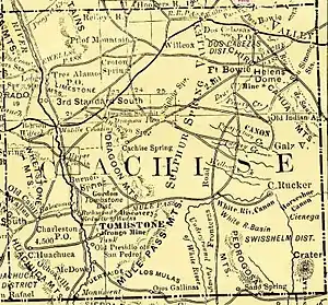
San Simon was the location of the San Simon Station of the Butterfield Overland Mail on the San Simon River between Apache Pass and Stein's Peak Stations. It was a later relay station established to provide water and change horses on the route.
In September 1880, Southern Pacific's rail line construction from the west reached San Simon and started rail service.[5] Once a junction was made in March 1881 with eastern rails in Deming, New Mexico, the line became the second transcontinental rail route across the United States.[6] San Simon was within Pima County until Cochise County was formed out of the eastern half of Pima in February 1881.[7]
San Simon School
The San Simon School is the K-12 school in San Simon, Arizona. It is the only school in the San Simon Unified School District. Its high school enrollment of 40 students makes it the second-smallest high school currently in the Arizona Interscholastic Association, only ahead of nearby Bowie High School. San Simon School as a district was rated No. 1 Arizona school for 2011, according to the Arizona Department of Education. The school received an A rating for 2012.[8]
Demographics
| Historical population | |||
|---|---|---|---|
| Census | Pop. | %± | |
| 2010 | 165 | — | |
| U.S. Decennial Census[9] | |||
As of the census of 2010, there were 165 people and 127 housing units in the CDP. The CDP was a new CDP created in the 2010 census. The population density was 237.5 people per square mile.[10] Prior to the 2010 census, the San Simon area was only a part of the much larger Bowie CCD for census purposes.
Climate
Climate occurs primarily on the outside of true deserts in low-latitude semiarid steppe regions. The Köppen Climate Classification subtype for this climate is BSk (Tropical and Subtropical Steppe Climate).
| Climate data for San Simon, AZ | |||||||||||||
|---|---|---|---|---|---|---|---|---|---|---|---|---|---|
| Month | Jan | Feb | Mar | Apr | May | Jun | Jul | Aug | Sep | Oct | Nov | Dec | Year |
| Average high °C (°F) | 16 (60) |
18 (65) |
22 (71) |
27 (80) |
31 (88) |
37 (98) |
37 (98) |
35 (95) |
33 (91) |
28 (82) |
21 (69) |
16 (60) |
27 (80) |
| Average low °C (°F) | −3 (27) |
−1 (30) |
2 (35) |
5 (41) |
9 (48) |
14 (57) |
18 (65) |
18 (64) |
14 (57) |
7 (44) |
1 (33) |
−2 (28) |
7 (44) |
| Average precipitation mm (inches) | 18 (0.7) |
20 (0.8) |
15 (0.6) |
7.6 (0.3) |
5.1 (0.2) |
7.6 (0.3) |
43 (1.7) |
51 (2) |
23 (0.9) |
15 (0.6) |
15 (0.6) |
25 (1) |
240 (9.6) |
| Source: Weatherbase [11] | |||||||||||||
References
- "2016 U.S. Gazetteer Files". United States Census Bureau. Retrieved Jul 18, 2017.
- "Population and Housing Unit Estimates". Retrieved June 9, 2017.
- U.S. Geological Survey Geographic Names Information System: San Simon, Arizona
- Staff, Website Services & Coordination. "US Census Bureau 2010 Census Interactive Population Map". www.census.gov. Archived from the original on 2014-03-30.
- Ascarza, William (22 November 2015). Mining in Chiricahua Mountains had varied success, Arizona Daily Star
- (12 March 1881). Completion of the New Trans-Continental Route, Pacific Rural Press
- "Arizona Cultural Inventory Project". Archived from the original on 27 October 2014. Retrieved 29 December 2014.
- http://www.azed.gov/blog/2011/05/12/top-school-district-ranking/
- "Census of Population and Housing". Census.gov. Retrieved June 4, 2016.
- "U.S. Census website". United States Census Bureau. Retrieved 2008-01-31.
- "Weatherbase.com". Weatherbase. 2013. Retrieved on August 14, 2013.
Municipalities and communities of Cochise County, Arizona, United States | ||
|---|---|---|
| Cities | 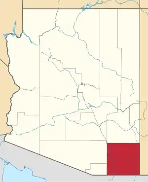 | |
| Towns | ||
| CDPs | ||
| Populated places |
| |
| Ghost towns | ||
| ||
