Sandy Lick Creek
Sandy Lick Creek[1] is a tributary of Redbank Creek in northwest Pennsylvania in the United States.[2]
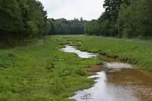
Sandy Lick Creek on the Beaver Meadow Walkway in DuBois, Pennsylvania
Sandy Lick Creek arises in Sandy Township north of Lake Sabula and joins North Fork Creek to form Redbank Creek in the borough of Brookville, Jefferson County.[2]
Political Subdivisions
The political subdivisions Sandy Lick Creek traverses, given in the order they are encountered traveling downstream, are as follows:
Tributaries
The named tributaries of Sandy Lick Creek, given in the order they are encountered traveling downstream, are as follows:
- Lake Sabula[10]
- Coal Run[11]
- Muddy Run[12]
- Narrows Creek[13]
- Gravel Lick Run[14]
- Laborde Branch[15]
- Reisinger Run[16]
- Pentz Run[17]
- Beaver Run[18]
- Clear Run[19]
- Slab Run[20]
- Wolf Run[21]
- Panther Run[22]
- Pitchpine Run[23]
- Soldier Run[24]
- Trout Run[25]
- Schoolhouse Run[26]
- O'Donnell Run[27]
- Camp Run[28]
- Fuller Run[29]
- Cable Run[30]
- Mill Creek[31]
- Fivemile Run[32]
References
- "Sandy Lick Creek". Geographic Names Information System. United States Geological Survey.
- Gertler, Edward. Keystone Canoeing, Seneca Press, 2004. ISBN 0-9749692-0-6
- "Sandy Township, Clearfield County". Geographic Names Information System. United States Geological Survey.
- "DuBois". Geographic Names Information System. United States Geological Survey.
- "Winslow township, Jefferson County". Geographic Names Information System. United States Geological Survey.
- "Reynoldsville borough, Jefferson County". Geographic Names Information System. United States Geological Survey.
- "Knox township, Jefferson County". Geographic Names Information System. United States Geological Survey.
- "Pine Creek township, Jefferson County". Geographic Names Information System. United States Geological Survey.
- "Brookville borough, Jefferson County". Geographic Names Information System. United States Geological Survey.
- "Lake Sabula". Geographic Names Information System. United States Geological Survey.
- "Coal Run". Geographic Names Information System. United States Geological Survey.
- "Muddy Run". Geographic Names Information System. United States Geological Survey.
- "Narrows Creek". Geographic Names Information System. United States Geological Survey.
- "Gravel Lick Run". Geographic Names Information System. United States Geological Survey.
- "Laborde Branch". Geographic Names Information System. United States Geological Survey.
- "Reisinger Run". Geographic Names Information System. United States Geological Survey.
- "Pentz Run". Geographic Names Information System. United States Geological Survey.
- "Beaver Run". Geographic Names Information System. United States Geological Survey.
- "Clear Run". Geographic Names Information System. United States Geological Survey.
- "Slab Run". Geographic Names Information System. United States Geological Survey.
- "Wolf Run". Geographic Names Information System. United States Geological Survey.
- "Panther Run". Geographic Names Information System. United States Geological Survey.
- "Pitchpine Run". Geographic Names Information System. United States Geological Survey.
- "Soldier Run". Geographic Names Information System. United States Geological Survey.
- "Trout Run". Geographic Names Information System. United States Geological Survey.
- "Schoolhouse Run". Geographic Names Information System. United States Geological Survey.
- "O'Donnell Run". Geographic Names Information System. United States Geological Survey.
- "Camp Run". Geographic Names Information System. United States Geological Survey.
- "Fuller Run". Geographic Names Information System. United States Geological Survey.
- "Cable Run". Geographic Names Information System. United States Geological Survey.
- "Mill Creek". Geographic Names Information System. United States Geological Survey.
- "Fivemile Run". Geographic Names Information System. United States Geological Survey.
This article is issued from Wikipedia. The text is licensed under Creative Commons - Attribution - Sharealike. Additional terms may apply for the media files.