Santiago–Tuguegarao Road
Santiago–Tuguegarao Road is a major road in the provinces of Cagayan,[1] Kalinga, and Isabela[2][3] in the Philippines. It is a bypass junction of the Pan-Philippine Highway, connecting to the cities of Tuguegarao and Santiago.
.svg.png.webp) .svg.png.webp) | ||||
|---|---|---|---|---|
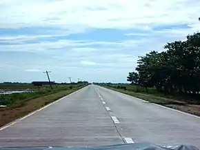 The Quezon, Isabela segment of the road. | ||||
| Route information | ||||
| Length | 130 km (80 mi) | |||
| Component highways |
| |||
| Major junctions | ||||
| South end | ||||
| ||||
| North end | ||||
| Location | ||||
| Provinces | Cagayan, Kalinga, Isabela | |||
| Major cities | Tuguegarao, Santiago | |||
| Highway system | ||||
| ||||
The road forms part of National Route 51 (N51) and National Route 53 (N53) of the Philippine highway network.
Route description

Buntun Bridge in Cagayan, which carries along the route.
Intersections
Intersections are numbered by kilometer post, with Rizal Park in Manila designated as kilometer zero.
| Region | Province | City/Municipality | km | mi | Destinations | Notes | |
|---|---|---|---|---|---|---|---|
| Cagayan Valley | Isabela | Santiago | 327 | 203 | Southern terminus. | ||
| Ramon | 340.5 | 211.6 | Burgos–Aguinaldo Road | ||||
| 341.8 | 212.4 | ||||||
| San Mateo | 350.9 | 218.0 | Alicia–San Mateo Road | ||||
| Cabatuan | 361.9 | 224.9 | South end of bypass. | ||||
| 363.3 | 225.7 | North end of bypass. | |||||
| Roxas | 382.6 | 237.7 | Gamu–Roxas Road | ||||
| Mallig | 392.7 | 244.0 | Ilagan–Delfin Albano–Mallig Road | ||||
| Santa Maria | 432 | 268 | |||||
| Cordillera Administrative Region | Kalinga | Tabuk | 408.7 | 254.0 | Abbut–Agbannawag Road | ||
| Rizal | 419.6 | 260.7 | Rizal National Road | ||||
| Cagayan Valley | Cagayan | Enrile | 437 | 272 | |||
| Solana | 452 | 281 | Cagayan–Apayao Road | ||||
| Tuguegarao | 456 | 283 | Northern terminus. | ||||
| 1.000 mi = 1.609 km; 1.000 km = 0.621 mi | |||||||
Bypass
Santiago–Tuguegarao Bypass Road
| |
|---|---|
| Location | Cabatuan, Isabela |
| Length | 2.275 km (1.414 mi) |
The Santiago–Tuguegarao Bypass Road is short bypass of Santiago–Tuguegarao Road in Cabatuan, Isabela. This bypass road is designated as National Route 53 (N53) of the Philippine highway network. With a length of 2.275 kilometres (1.414 mi), it is considered the shortest length of the national primary routes.
References
- "Cagayan 3rd". www.dpwh.gov.ph. Retrieved February 13, 2019.
- "Isabela 1st". www.dpwh.gov.ph. Retrieved February 13, 2019.
- "Isabela 2nd". www.dpwh.gov.ph. Retrieved February 13, 2019.
| National primary roads |
| |||||||
|---|---|---|---|---|---|---|---|---|
| National secondary roads |
| |||||||
See also: Philippine expressway network | ||||||||
This article is issued from Wikipedia. The text is licensed under Creative Commons - Attribution - Sharealike. Additional terms may apply for the media files.