Saratoga, Wyoming
Saratoga is a town in Carbon County, Wyoming. The population was 1,690 at the 2010 census.
Saratoga, Wyoming | |
|---|---|
 Location of Saratoga in Carbon County, Wyoming. | |
 Saratoga, Wyoming Location in the United States | |
| Coordinates: 41°27′16″N 106°48′30″W | |
| Country | United States |
| State | Wyoming |
| County | Carbon |
| Government | |
| • Mayor | John Zeiger |
| Area | |
| • Total | 3.59 sq mi (9.29 km2) |
| • Land | 3.40 sq mi (8.80 km2) |
| • Water | 0.19 sq mi (0.49 km2) |
| Elevation | 6,791 ft (2,070 m) |
| Population | |
| • Total | 1,690 |
| • Estimate (2019)[3] | 1,615 |
| • Density | 475.28/sq mi (183.49/km2) |
| Time zone | UTC−7 (Mountain (MST)) |
| • Summer (DST) | UTC−6 (MDT) |
| ZIP code | 82331 |
| Area code | 307 |
| FIPS code | 56-68685[4] |
| GNIS feature ID | 1609150[5] |
| Website | http://www.saratoga.govoffice2.com/ |
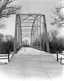
Saratoga is the home of the Steinley Cup microbrew festival and competition,[6] usually held in August at Veterans Island Park, a playground and picnic facility on a small island in the North Platte River, which is designated a Blue Ribbon Stream by the Wyoming Game and Fish.[7] Saratoga also has a public pool heated by a hot spring. Its two largest employers are the United States Forest Service and Carbon County School District No. 2, both public sector employers. The town's motto is "Where The Trout Leap In Main Street." The local newspaper is the Saratoga Sun.[8]
Geography and climate
Saratoga is located at 41°27′16″N 106°48′30″W (41.454474, -106.808413).[9]
According to the United States Census Bureau, the town has a total area of 3.59 square miles (9.30 km2), of which 3.40 square miles (8.81 km2) is land and 0.19 square miles (0.49 km2) is water.[10]
| Climate data for Saratoga, Wyoming (1981–2010) | |||||||||||||
|---|---|---|---|---|---|---|---|---|---|---|---|---|---|
| Month | Jan | Feb | Mar | Apr | May | Jun | Jul | Aug | Sep | Oct | Nov | Dec | Year |
| Average high °F (°C) | 34.2 (1.2) |
36.8 (2.7) |
46.0 (7.8) |
56.0 (13.3) |
66.0 (18.9) |
76.2 (24.6) |
82.7 (28.2) |
81.0 (27.2) |
71.6 (22.0) |
58.9 (14.9) |
42.9 (6.1) |
34.1 (1.2) |
57.2 (14.0) |
| Average low °F (°C) | 12.0 (−11.1) |
13.8 (−10.1) |
21.8 (−5.7) |
28.3 (−2.1) |
36.4 (2.4) |
44.3 (6.8) |
50.4 (10.2) |
48.7 (9.3) |
39.9 (4.4) |
30.0 (−1.1) |
19.8 (−6.8) |
11.9 (−11.2) |
29.8 (−1.2) |
| Average precipitation inches (mm) | 0.44 (11) |
0.51 (13) |
0.70 (18) |
1.00 (25) |
1.44 (37) |
0.94 (24) |
1.02 (26) |
1.00 (25) |
1.01 (26) |
1.06 (27) |
0.66 (17) |
0.40 (10) |
10.19 (259) |
| Average snowfall inches (cm) | 8.8 (22) |
7.7 (20) |
8.7 (22) |
6.3 (16) |
1.7 (4.3) |
0.0 (0.0) |
0.0 (0.0) |
0.0 (0.0) |
1.0 (2.5) |
3.7 (9.4) |
8.9 (23) |
7.9 (20) |
54.7 (139) |
| Source: NOAA[11] | |||||||||||||
Demographics
| Historical population | |||
|---|---|---|---|
| Census | Pop. | %± | |
| 1910 | 557 | — | |
| 1920 | 449 | −19.4% | |
| 1930 | 567 | 26.3% | |
| 1940 | 810 | 42.9% | |
| 1950 | 926 | 14.3% | |
| 1960 | 1,133 | 22.4% | |
| 1970 | 1,181 | 4.2% | |
| 1980 | 2,410 | 104.1% | |
| 1990 | 1,969 | −18.3% | |
| 2000 | 1,726 | −12.3% | |
| 2010 | 1,690 | −2.1% | |
| 2019 (est.) | 1,615 | [3] | −4.4% |
| U.S. Decennial Census[12] | |||
2010 census
As of the census[2] of 2010, there were 1,690 people, 802 households, and 474 families residing in the town. The population density was 497.1 inhabitants per square mile (191.9/km2). There were 979 housing units at an average density of 287.9 per square mile (111.2/km2). The racial makeup of the town was 94.4% White, 0.9% Native American, 0.6% Asian, 2.2% from other races, and 1.9% from two or more races. Hispanic or Latino of any race were 5.1% of the population.
There were 802 households, of which 21.8% had children under the age of 18 living with them, 48.0% were married couples living together, 6.7% had a female householder with no husband present, 4.4% had a male householder with no wife present, and 40.9% were non-families. 34.2% of all households were made up of individuals, and 13% had someone living alone who was 65 years of age or older. The average household size was 2.07 and the average family size was 2.62.
The median age in the town was 48.9 years. 17.6% of residents were under the age of 18; 4.8% were between the ages of 18 and 24; 21.3% were from 25 to 44; 34.6% were from 45 to 64; and 21.6% were 65 years of age or older. The gender makeup of the town was 51.3% male and 48.7% female.
2000 census
As of the census[4] of 2000, there were 1,726 people, 757 households, and 482 families residing in the town. The population density was 505.7 people per square mile (195.4/km2). There were 939 housing units at an average density of 275.1 per square mile (106.3/km2). The racial makeup of the town was 95.42% White, 0.12% African American, 0.81% Native American, 0.70% Asian, 0.06% Pacific Islander, 1.56% from other races, and 1.33% from two or more races. Hispanic or Latino of any race were 4.11% of the population.
There were 757 households, out of which 27.9% had children under the age of 18 living with them, 52.4% were married couples living together, 7.3% had a female householder with no husband present, and 36.3% were non-families. 31.8% of all households were made up of individuals, and 12.8% had someone living alone who was 65 years of age or older. The average household size was 2.23 and the average family size was 2.79.
In the town, the age distribution of the population shows 23.1% under the age of 18, 5.2% from 18 to 24, 25.3% from 25 to 44, 28.9% from 45 to 64, and 17.6% who were 65 years of age or older. The median age was 43 years. For every 100 females, there were 100.9 males. For every 100 females age 18 and over, there were 101.2 males.
The median income for a household in the town was $37,135, and the median income for a family was $45,362. Males had a median income of $32,446 versus $20,489 for females. The per capita income for the town was $23,376. About 8.4% of families and 10.0% of the population were below the poverty line, including 10.0% of those under age 18 and 12.2% of those age 65 or over.
Government
Saratoga has a town council consisting of four councilmembers and the mayor. As of March 2020, the mayor is John Zeiger.[13]
Notable people
- Howard Thomas Orville (1901–1960), naval officer and meteorologist born in Saratoga
- Garrett Price (1895–1979) lived in Saratoga as a boy and later wrote and illustrated a Sunday comic strip, set in the town and called ″White Boy,″ which appeared in the Chicago Tribune during the 1930s.[14]
- Annie Proulx, novelist
- C. C. Beall, commercial illustrator and portrait artist
Education
Public education in Saratoga is provided by Carbon County School District Number 2.
Saratoga has two schools, Saratoga High School and Saratoga Elementary School. The middle school was closed and demolished in 2005. After its destruction, the classes that had been in that building were separated, part of them attending the elementary school and the remainder the high school. Saratoga has redeveloped an old school building into the multi-use Platte Valley Community Center, which hosts concerts, lectures, theatrical performance, and community events.
Saratoga has a public library, a branch of the Carbon County Library System.[15]
References
- "2019 U.S. Gazetteer Files". United States Census Bureau. Retrieved August 7, 2020.
- "U.S. Census website". United States Census Bureau. Retrieved 2012-12-14.
- "Population and Housing Unit Estimates". United States Census Bureau. May 24, 2020. Retrieved May 27, 2020.
- "U.S. Census website". United States Census Bureau. Retrieved 2008-01-31.
- "US Board on Geographic Names". United States Geological Survey. 2007-10-25. Retrieved 2008-01-31.
- "Steinley Cup Microbrew Festival and Competition Saratoga, Wyoming". CraftBeer.com. 2019-05-14. Retrieved 2019-11-14.
- Smith, Mark. "Ask Game and Fish". Wyoming Game and Fish Department. Retrieved 2019-11-14.
- Saratoga Sun information from the Wyoming Press Association Saratoga is also home to the Old Baldy Club and in the summer hosts fishermen from all over trying their luck on the blue ribbon trout waters of the North Platte River.
- "US Gazetteer files: 2010, 2000, and 1990". United States Census Bureau. 2011-02-12. Retrieved 2011-04-23.
- "US Gazetteer files 2010". United States Census Bureau. Archived from the original on 2012-07-02. Retrieved 2012-12-14.
- "NOWData - NOAA Online Weather Data". National Oceanic and Atmospheric Administration. Retrieved May 5, 2013.
- "Census of Population and Housing". Census.gov. Retrieved June 4, 2015.
- "Mayor and Council - Saratoga, WY". Town of Saratoga. Retrieved March 24, 2020.
- Garrett Price, White Boy, p. 9
- "Wyoming Public Libraries". PublicLibraries.com. Retrieved 13 June 2019.
External links
| Wikimedia Commons has media related to Saratoga, Wyoming. |
Municipalities and communities of Carbon County, Wyoming, United States | ||
|---|---|---|
| Cities | 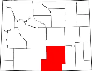 | |
| Towns | ||
| CDPs | ||
| Unincorporated communities | ||
| Ghost towns | ||
| ||
| Authority control |
|---|