Satipo Province
Satipo Province (Spanish: Provincia de Satipo) is the largest and easternmost province in the Junín Region, located in the central Amazon rainforest of Peru. Its capital is the town of Satipo.
Satipo Province | |
|---|---|
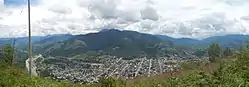 Aerial of Satipo City | |
 Coat of arms | |
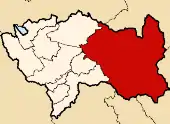 Location of Satipo Province in the Junín Region | |
| Country | Peru |
| Region | Junín |
| Founded | March 26, 1965 |
| Capital | Satipo |
| Government | |
| • Mayor | Olivera Meza (2019-2022) |
| Area | |
| • Total | 19,219.48 km2 (7,420.68 sq mi) |
| Population | |
| • Total | 203,985 |
| • Density | 11/km2 (27/sq mi) |
Geography
The Satipo Province borders the provinces of Huancayo, Concepción, Jauja and Chanchamayo on the west; Pasco Region's Oxapampa Province on the north; Atalaya Province in the Ucayali Region on the northwest; and Cusco Region's La Convención Province on the east and southeast. The Mantaro River marks the province's border with Ayacucho Region's Huanta Province on the south and Huancavelica Region's Tayacaja Province on the southwest.
Elevations and climates in Satipo province range from the Amazon Basin tropical rainforest climate along the Tambo River near Atalaya at an elevation of 207 m (679 ft) to Nevado Bateadora with an elevation of 4,866 m (15,965 ft) near the hamlet of Toldopampa in the Andes.[1]
History
The first inhabitants of present-day Satipo Province were the Asháninkas, Piros, Amueshas, Nomatsiguengas, Simirinches, Amewakas, Cakintis, among others. They left a legacy of petroglyphs which are believed to be from more than 3500 years ago. Ceramics, stone and golden axes, as well as many constructions show that the area was also inhabited by the Incas. Many battles were fought between the Incas and the other natives, whose extensive knowledge of the jungle helped them win.
The first Europeans arrived in the province's territory in 1673, when the Franciscans founded Santa Cruz, their first settlement in the area.
Many Indian uprisings happened during the 18th century.
President Manuel Prado created the Satipo District as part of the Jauja Province on September 18, 1940.
On November 1, 1947, a strong earthquake destroyed the city, causing entire settlements to disappear. Satipo could not be reached by land and remained isolated until 1960.
The district of Satipo was elevated to the provincial status by President Fernando Belaúnde Terry on March 26, 1965.
During the late 1980s, the province was hit hard by terrorism and caused a massive exodus from the province. Many persons were killed by terrorists, including the Mayor of Satipo, Fidel Juarez Torres.
Political divisions
Satipo Province is divided into nine districts (Spanish: distritos, singular: distrito), each of which is headed by a mayor (alcalde):
| Districts of Satipo Province[2] | ||||||
|---|---|---|---|---|---|---|
| District | Capital | Area | Population (1993) | Population (2017) | elevation (of capital) | coordinates (of capital) |
| Coviriali | Coviriali | 98 km2 (38 sq mi) | 3,457 | 6,248 | 675 m (2,215 ft) | 11.291°S 74.627°W |
| Llaylla | Llaylla | 308 km2 (119 sq mi) | 3,168 | 6,936 | 1,108 m (3,635 ft) | 11.381°S 74.591°W |
| Mazamari | Mazamari | 2,134 km2 (824 sq mi) | 12,487 | 40,211 | 661 m (2,169 ft) | 11.325°S 74.580°W |
| Pampa Hermosa | Mariposa | 951 km2 (367 sq mi) | 3,543 | 4,090 | 1,232 m (4,042 ft) | 11.404°S 74.752°W |
| Pangoa | San Martin de Pangoa | 3,536 km2 (1,365 sq mi) | 20,603 | 60,883 | 775 m (2,543 ft) | 11.428°S 74.448°W |
| Rio Negro | Rio Negro | 488 km2 (188 sq mi) | 18,772 | 32,304 | 644 m (2,113 ft) | 11.208°S 74.660°W |
| Rio Tambo | Puerto Ocopa | 10,213 km2 (3,943 sq mi) | 9,155 | 29,131 | 330 m (1,080 ft) | 11.144°S 74.308°W |
| Satipo | Satipo | 816 km2 (315 sq mi) | 23,605 | 41,050 | 628 m (2,060 ft) | 11.254°S 74.637°W |
| Vizcatán del Ene | San Miquel del Ene | 608 km2 (235 sq mi) | n.a. | 4,765 | 469 m (1,539 ft) | 12.214°S 74.016°W |
| Total: Satipo | Satipo | 19,219 km2 (7,420 sq mi) | 94,250 | 225,618 | 628 m (2,060 ft) | 11.254°S 74.637°W |
Gallery
 Zoo in Satipo.
 Banana farm.
 Public lands bridge.
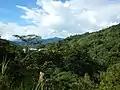 Jungle overview
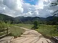 Typical farm in Satipo.
External links
References
- Google Earth
- "Junin Region". City Population. Retrieved 7 Aug 2020.
| |
|---|---|