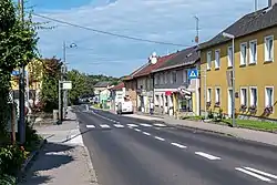
Sattledt
Sattledt is a municipality in the district of Wels-Land in the Austrian state of Upper Austria.
Sattledt | |
|---|---|
 | |
 Coat of arms | |
 Sattledt Location within Austria | |
| Coordinates: 48°04′24″N 14°03′27″E | |
| Country | Austria |
| State | Upper Austria |
| District | Wels-Land |
| Government | |
| • Mayor | Gerhard Huber (ÖVP) |
| Area | |
| • Total | 22.16 km2 (8.56 sq mi) |
| Elevation | 400 m (1,300 ft) |
| Population (2018-01-01)[2] | |
| • Total | 2,668 |
| • Density | 120/km2 (310/sq mi) |
| Time zone | UTC+1 (CET) |
| • Summer (DST) | UTC+2 (CEST) |
| Postal code | 4642 |
| Area code | 07244 |
| Vehicle registration | WL |
| Website | www.sattledt.at |
Population
| Year | Pop. | ±% |
|---|---|---|
| 1869 | 1,014 | — |
| 1880 | 998 | −1.6% |
| 1890 | 972 | −2.6% |
| 1900 | 978 | +0.6% |
| 1910 | 1,147 | +17.3% |
| 1923 | 1,225 | +6.8% |
| 1934 | 1,286 | +5.0% |
| 1939 | 1,450 | +12.8% |
| 1951 | 1,806 | +24.6% |
| 1961 | 1,630 | −9.7% |
| 1971 | 1,810 | +11.0% |
| 1981 | 1,971 | +8.9% |
| 1991 | 2,176 | +10.4% |
| 2001 | 2,241 | +3.0% |
| 2010 | 2,327 | +3.8% |
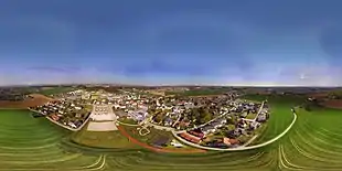
360° airborne panorama of the center of Sattledt
(view as a 360° interactive panorama)
(view as a 360° interactive panorama)
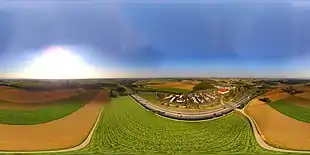
360° airborne panorama, shot northwest of motorway junction Voralpenkreuz
(view as a 360° interactive panorama)
(view as a 360° interactive panorama)
References
- "Dauersiedlungsraum der Gemeinden Politischen Bezirke und Bundesländer - Gebietsstand 1.1.2018". Statistics Austria. Retrieved 10 March 2019.
- "Einwohnerzahl 1.1.2018 nach Gemeinden mit Status, Gebietsstand 1.1.2018". Statistics Austria. Retrieved 9 March 2019.
| Wikimedia Commons has media related to Sattledt. |
| Authority control |
|---|
This article is issued from Wikipedia. The text is licensed under Creative Commons - Attribution - Sharealike. Additional terms may apply for the media files.