Seeley Lake, Montana
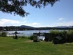
Seeley Lake is a census-designated place (CDP) in Missoula County, Montana, United States. It is part of the 'Missoula, Montana Metropolitan Statistical Area'. The town sits beside the 1,031.5 acres lake Seeley Lake.[1] The population was 1,659 at the 2010 census, an increase from its population of 1,436 in 2000.
Seeley Lake, Montana | |
|---|---|
 | |
 Location of Seeley Lake, Montana | |
| Coordinates: 47°10′1″N 113°28′1″W | |
| Country | United States |
| State | Montana |
| County | Missoula |
| Area | |
| • Total | 11.0 sq mi (28.6 km2) |
| • Land | 10.9 sq mi (28.2 km2) |
| • Water | 0.1 sq mi (0.4 km2) |
| Elevation | 4,019 ft (1,225 m) |
| Population (2010) | |
| • Total | 1,659 |
| • Density | 131.9/sq mi (50.9/km2) |
| Time zone | UTC-7 (Mountain (MST)) |
| • Summer (DST) | UTC-6 (MDT) |
| ZIP code | 59868 |
| Area code(s) | 406 |
| FIPS code | 30-67150 |
| GNIS feature ID | 0799011 |
Geography
Seeley Lake is located at 47°10′1″N 113°28′1″W (47.166892, -113.466817).[2]
According to the United States Census Bureau, the CDP has a total area of 11.0 square miles (28 km2), of which 10.9 square miles (28 km2) is land and 0.2 square miles (0.52 km2) (1.36%) is water.
Aftermath of Rice Ridge Fire
In late summer 2017, Seeley Lake suffered an extended period of hazardous air quality as a result of the Rice Ridge Fire, prompting local officials to urge all residents to evacuate their homes.[3] Scooper aircraft were used to fetch water from Seeley Lake to fight the fire.[4] A followup study will measure the health impacts of the smoke.[5]
Demographics
As of the census[6] of 2010, there were 1,659 people, 589 households, and 411 families residing in the CDP. The population density was 131.9 people per square mile (50.9/km2). There were 938 housing units at an average density of 86.2 per square mile (33.3/km2). The racial makeup of the CDP was 96.94% White, 0.07% African American, 1.46% Native American, 0.21% Asian, 0.49% from other races, and 0.84% from two or more races. Hispanic or Latino of any race were 1.46% of the population.
There were 589 households, out of which 29.2% had children under the age of 18 living with them, 59.4% were married couples living together, 5.1% had a female householder with no husband present, and 30.1% were non-families. 24.3% of all households were made up of individuals, and 6.3% had someone living alone who was 65 years of age or older. The average household size was 2.44 and the average family size was 2.89.
In the CDP, the population was spread out, with 25.3% under the age of 18, 5.2% from 18 to 24, 28.3% from 25 to 44, 29.5% from 45 to 64, and 11.8% who were 65 years of age or older. The median age was 41 years. For every 100 females, there were 113.4 males. For every 100 females age 18 and over, there were 112.1 males.
The median income for a household in the CDP was $35,101, and the median income for a family was $38,188. Males had a median income of $30,000 versus $18,269 for females. The per capita income for the CDP was $18,825. About 7.0% of families and 10.6% of the population were below the poverty line, including 14.4% of those under age 18 and 4.8% of those age 65 or over.
See also
References
- "FISHMT :: Waterbody Details". myfwp.mt.gov. Retrieved 2018-10-02.
- "US Gazetteer files: 2010, 2000, and 1990". United States Census Bureau. 2011-02-12. Retrieved 2011-04-23.
- Volz, Matt (2017-08-10). "Residents of Smoke-Choked Montana Town Advised to Leave". US News and World Report - AP. Archived from the original on 2017-09-26.
- Randy Teague (2017-08-04), Scoop Planes Fire Bombers 2 Seeley Lake, Mont. 8-1-2017, retrieved 2017-09-25
- Associated Press (2017-09-22). "Researchers launch study to learn effects of wildfire smoke". Missoulian. Retrieved 2017-09-25.
- "U.S. Census website". United States Census Bureau. Retrieved 2008-01-31.
External links
| Wikimedia Commons has media related to Seeley Lake, Montana. |
Municipalities and communities of Missoula County, Montana, United States | ||
|---|---|---|
| City | 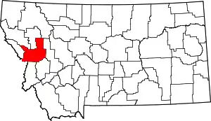 Missoula County map | |
| CDPs | ||
| Unincorporated communities | ||
| Ghost towns | ||
| Indian reservation | ||
| Footnotes | ‡This populated place also has portions in an adjacent county or counties | |
| ||