Serras de Aire e Candeeiros Natural Park
Serras de Aire e Candeeiros Natural Park (PNSAC) is a natural park in Portugal. It is one of the 30 areas which are officially under protection in the country. It is the most important repository of limestone formations in Portugal (with karst erosion giving rise to characteristic geological formations such as caves, algars, dolinas, uvala, polje, fields of lapiás, sinks, among others).[2]
| Serras de Aire e Candeeiros Natural Park | |
|---|---|
| Serras de Aire e Candeeiros | |
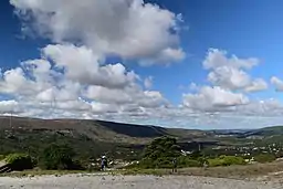 View of Serras de Aire and Candeeiros Natural Park | |
 | |
| Coordinates | 39°30′20″N 8°47′30″W |
| Elevation | 120–679 metres (394–2,228 ft)[1] |
| Highest point – elevation | Serra de Aire 679 m (2,228 ft) |
| Area | 38.900 hectares (96.12 acres) |
Location
The park is located in the central region of Portugal marking the border between the provinces of Beira Litoral, Ribatejo and Estremadura. It comprises part of the municipalities of Rio Maior, Alcobaça, Porto de Mós, Batalha, Leiria, Ourém, Torres Novas and Alcanena.[3]
This area was made a protected area in 1979 with the intend to protect the existing natural aspects and architectonic heritage.
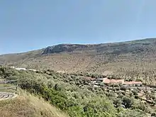
PNSAC is mainly composed by mountain ranges (Serra) and plateaus: Serra de Aire in the northeast, Serra de Candeeiros in the west, adjacent to Aire, between Porto de Mós and Rio Maior, the Santo António plateau in the centre and part of the São Mamede plateau in the north, and Serra de Santo António, perpendicular to both Aire and Candeeiros.[1]
Characteristics
Due to the extreme permeability of the limestones, the park is absent of shallow watercourses, instead, it has a vast network of underground galleries, being perhaps one of the largest freshwater reservoirs in the country, giving rise to some important water courses, such as the Alviela and Lena rivers.[1] Another striking characteristic of the landscape is the consequent dryness, to which faults, escarpments and rocky outcrops give the park a vigorous and harsh trace.[2]
This nature park is evidenced by the relief, as a prominent mass that rises about 200 m (660 ft) relative to its surroundings and for its geological constitution of highly permeable limestone targets, to which results its great dryness. And water, which is practically invisible on the surface, the main erosive agent, modeler of this unusual morphology. The character of these landscapes is also associated with presence of countless stone walls, depressions (poljes) with a varied agricultural use and the olive groves on stony and difficult to work slopes, for which pits are opened and terraces or stone walls are built to hold the scarce existing soil.[2]
The relatively abundant rains quickly disappear through the cracks in the stripped rocks where installs a Mediterranean vegetation of Quercus coccifera, Pistacia lentiscus, wild olive and aromatic herbs.[2]
In the low areas or in the depressions where water is collected and accumulates from infiltration at the higher surfaces, there are processes that have similarities with the river dynamics that enriches the flood beds with sediments - after the accumulation period, of water in the poldjes, the depressions are emptied which gives rise to a fertile terra rossa plain where maize, potatoes, vines are grown, a variety of other crops and even vegetable gardens, resulting in a mosaic of colors and textures with great seasonal dynamics.[2]
The karst landscape still has a high aesthetic value due to the fact that erosive phenomena, both superficial as well as underground, gives rise to expressive and unexpected “natural sculptures”.[2]
The settlement is originally concentrated on the periphery of the limestone massifs and is largely determined by availability of water. Currently, with the population less dependent on agricultural and pastoral activities, there has been a dispersion of buildings in the landscape, both for housing and for support of other economic activities. This diversification of the economy is partly responsible for the abandonment of the most traditional activities.[2]
Geology
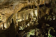
The park is located in the Estremenho Limestone Massif where complete sedimentary series of several Jurassic floors and tectonic accidents that testify not only to the distensive phases of opening the Lusitanian Basin during the Mesozoic, but also the alpine compressive regimes that were installed from the end of the Cretaceous. Among the testimonies of high scientific value in the park, the paleontological heritage, with an exceptional set of dinosaur ichnofossils, stands out. Also the occurrence of geological cuts and the unique exposure of representative lithostratigraphic sequences in the evolution of depositional environments and the occurrence of some imposing fault cliffs. However, it is with regard to the elements of nature that the PNSAC stands out the most, being considered as the most important karst region in Portugal. The scarce runoff from the waters gives rise to an extensive and complex underground drainage system which results in a unique speleological heritage, represented by countless algars and caves.[4]
Flora
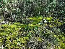
The natural park hosts more than 600 different plant species,[5] most are Mediterranean while others are Atlantic, the typical cover includes: Quercus coccifera, Quercus rotundifolia,Quercus faginea, Quercus suber, Phillyrea latifolia, Rhamnus alaternus, Pistacia lentiscus, Olea oleaster, Olea europaea, Lavandula stoechas, rosemary, oregano, Hedera hibernica, Erica arborea, bay laurel, Arbutus unedo and the occasional maritime pine and stone pine forests.[6]
It has 27 different species of orchid, about 50% of all the species native to Portugal.[1]
It also provides habitat for various flora that is uncommonly found in Portugal including: Iris subbiflora, Paeonia broteri, Paeonia officinalis, Jonopsidium abulense, Orobanche latisquama, Scrophularia sambucifolia, Antirrhinum linkianum Teucrium chamaedrys, Salvia viridis, Inula montana, Aristolochia pistolochia, Teucrium fruticans, Ophrys fusca, Fritillaria lusitanica and some Portuguese endemics such as Silene longicilia, Arabis sadina, Arrhenatherum pallens, Ulex jussiaei, Narcissus calcicola, Ulex airensis, Saxifraga cintrana and a newly described species, Arenaria grandiflora, which is currently only known to exist in the park.[6]
Fauna
Although lacking any water courses, the park has a surprising amount of amphibians, 13 species are known, which include the marbled newt, the Iberian ribbed newt, the western spadefoot, the common midwife toad, the Iberian painted frog, the Mediterranean tree frog, the Iberian frog, the Perez's frog, among others.[1][7]
Reptiles include the spiny-footed lizard, the horseshoe whip snake, the Carbonell's wall lizard, the Iberian wall lizard, the Spanish psammodromus, the ocellated lizard, and the Lataste's viper.[1]
Bats represent almost half of the mammal species in the park, with 21 known different species.[1][7]
Climate
The park has a Mediterranean climate, with mild, rainy winters and warm to hot, dry summers but variations in temperature, precipitation and insolation occur. Areas closer to the Atlantic have warm summers (with average summer highs around 24 °C (75 °F)) whilst areas that border the Ribatejo tend to have hot summers (with average summer highs around 28–29 °C (82–84 °F). Altitude also plays a role, at altitudes above 400 m (1,300 ft), precipitation is plenty, with values above 1,200 mm (47 in) per year, but can go down to 800 mm (31 in) at lower altitudes.[1] Average temperature ranges from 13.5 °C (56.3 °F) at the top of Serra de Aire, to 16.0 °C (60.8 °F) at the lower plains.[8][9]
Fog is very common in winter, and in the summer, morning fog is also usual. Average relative humidity is very high in the winter and values in the summer can have extreme variations, often below 40% during the day and above 80% at night. Temperatures at night are generally cool year-round but the high humidity along an absence of wind can make it more pleasant. Insolation varies between 2300 hours in the northwest mountains (south of Porto de Mós) and 2650 hours in the east.[8][9] In general, Serra dos Candeeiros has a more Atlantic influenced climate, whereas Serra de Aire has a more Mediterranean influenced climate.
| Climate data for Arrimal, Serra de Candeeiros, altitude: 322 m (1,056 ft), 1980-1996 | |||||||||||||
|---|---|---|---|---|---|---|---|---|---|---|---|---|---|
| Month | Jan | Feb | Mar | Apr | May | Jun | Jul | Aug | Sep | Oct | Nov | Dec | Year |
| Average precipitation mm (inches) | 131.2 (5.17) |
144.1 (5.67) |
81.5 (3.21) |
122.9 (4.84) |
94.3 (3.71) |
36.9 (1.45) |
10.7 (0.42) |
12.4 (0.49) |
49.2 (1.94) |
107.0 (4.21) |
170.0 (6.69) |
171.7 (6.76) |
1,131.9 (44.56) |
| Source: Agência Portuguesa do Ambiente[10] | |||||||||||||
Paleontology
The park contains two Middle Jurassic tracksites, the sauropod footprints of Serra de Aire and the dinosaur footprints of Vale de Meios, both are the oldest known dinosaur footprints in the Iberian Peninsula.[11] The Serra de Aire tracksite is one of the few sites in the world where Middle Jurassic sauropod dinosaur tracks can be found.[12] The Cave of Aroeira near the park has the earliest recorded human trace in Portugal, along with deer, equids, rhinoceros, bear, a large bovid, a caprid, and a Testudo tortoise. The Jurassic Beach of São Bento, discovered in 2003, has a variety of fossilized echinoderms.[13] Squeletal remains of Pleistocene brown bears have also been discovered in Algar do Vale da Pena, near the village of Moita do Poço.[14] There are also Roman remains, notably a road in Alqueidão da Serra, Porto de Mós which dates between the centuries I AD and I BC.[15]
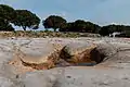 Theropod footprint in Vale de Meios
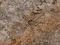
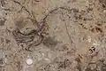
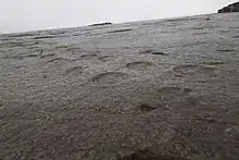 Sauropod footprints of the Serra de Aire Natural Monument
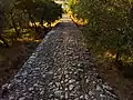 Roman road of Alqueidão da Serra
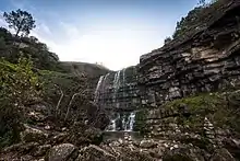
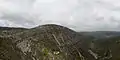 Fórnea
Threats
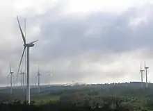
Even though a protected nature area was created to protect the existing natural aspects and architectonic heritage, the construction of quarries and wind turbines have increased since then, placing many of the local fauna and flora at risk. Every year, dozens of birds and bats are killed by the blades of wind turbines and severe numbers of reptile and amphibian species are roadkilled.[1] Some measurements taken to prevent this include the investment in nature tourism, scientific investigation and agriculture, particularly biological farming.[16]
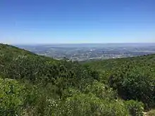
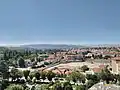
Views of the park from urban centers
 East side of Serra de Aire as seen from the castle of Torres Novas
.jpg.webp) West side of Serra de Aire as seen from Fátima
West side of Serra de Aire as seen from Fátima.jpg.webp) Southeast view of Serra de Santo António from Alcanena
Southeast view of Serra de Santo António from Alcanena.jpg.webp) West side view of Serra de Candeeiros from Alcobaça
West side view of Serra de Candeeiros from Alcobaça
References
- "Avaliação dos Impactes Ambientais dos Parques Eólicos em Áreas Protegidas: O Caso de Estudo do Parque Natural das Serras de Aire e Candeeiros" (PDF). Catarina Isabel Augusto Coelho. Retrieved 15 December 2020.
- "Programa Regional de Ordenamento Florestal" (PDF). ICNF. Retrieved 15 December 2020.
- "Enquadramento Geológico e Geomorfológico". grutasdemiradeaire.com. Retrieved 15 December 2020.
- "Geological heritage assessment in mining areas of serra de aire and candeeiros natural park". Jorge Manuel Ferreira Carvalho. Retrieved 15 December 2020.
- "Serra de Aire e Candeeiros". Minde Parish Council. Retrieved 15 December 2020.
- "área protegida: serras de aire e candeeiros". Flora-on. Retrieved 15 December 2020.
- "Parque Natural das Serras de Aire e Candeeiros". Turismo Médio Tejo. Retrieved 15 December 2020.
- Paulo Jorge Silva Ferreira. "O património edificado molinológico no concelho de Porto de Mós: Reflexão para a sua preservação e reutilização na Serra de Candeeiros" (PDF). Universidade Lusófona. Retrieved 16 December 2020.
- "Prospect". Solaris. Retrieved 15 December 2020.
- "Estudo de Impacte Ambiental da "Pedreira Vale do Mar"" (PDF). APA. Retrieved 12 December 2020.
- "Pegadas de Dinossauros de Vale dos Meios – Alcanede". serrasdeaireecandeeiros.com. Retrieved 15 December 2020.
- Vanda F. Santos, José J. Moratalla, Rafael Royo-Torres. "New Sauropod Trackways from the Middle Jurassic of Portugal". BioOne. Retrieved 15 December 2020.CS1 maint: multiple names: authors list (link)
- "Praia Jurássica de São Bento". serrasdeaireecandeeiros.com. Retrieved 15 December 2020.
- Dário Estraviz-López, Octávio Mateus. "Tracks and multiple skeletons of brown bear (ursus arctos) in Algar do Vale da Pena, Portugal" (PDF). NOVA University Lisbon. Retrieved 15 December 2020.
- "Estrada Romana - Alqueidão da Serra". municipio-portodemos.pt. Retrieved 30 January 2021.
- "Quercus faz balanço da intervenção no Parque Natural da Serra de Aire e Candeeiros, que cumpriu recentemente 35 anos". Quercus (organization). Retrieved 15 December 2020.
