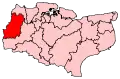
Sevenoaks District
Sevenoaks is a local government district[1] in west Kent, England. Its council is based in the town of Sevenoaks.
Sevenoaks | |
|---|---|
 Sevenoaks shown within Kent | |
| Sovereign state | United Kingdom |
| Constituent country | England |
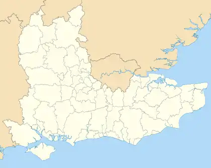
| Region | South East England |
| Non-metropolitan county | Kent |
| Status | Non-metropolitan district |
| Admin HQ | Sevenoaks |
| Incorporated | 1 April 1974 |
| Government | |
| • Type | Non-metropolitan district council |
| • Body | Sevenoaks District Council |
| • Leadership | Leader & Cabinet (Conservative) |
| • MPs | Laura Trott Gareth Johnson Tom Tugendhat |
| Area | |
| • Total | 142.99 sq mi (370.34 km2) |
| Area rank | 107th (of 317) |
| Population (mid-2019 est.) | |
| • Total | 120,750 |
| • Rank | 193rd (of 317) |
| • Density | 840/sq mi (330/km2) |
| • Ethnicity | 95.2% White 1.5% S.Asians 1.2% Black 1.2% Mixed Race |
| Time zone | UTC0 (GMT) |
| • Summer (DST) | UTC+1 (BST) |
| ONS code | 29UK (ONS) E07000111 (GSS) |
| OS grid reference | TQ525555 |
| Website | www |
The district was formed on 1 April 1974 by the merger of Sevenoaks Urban District, Sevenoaks Rural District and part of Dartford Rural District.
Geography
The area is approximately evenly divided between buildings and infrastructure on the one hand and woodland or agricultural fields on the other. It contains the upper valley of the River Darenth and some headwaters of the River Eden.
The vast majority of the district is covered by the Metropolitan Green Belt.
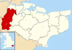
In terms of districts, it borders Dartford to the north, Gravesham to the northeast, Tonbridge and Malling to the east, briefly Tunbridge Wells to the southeast. It also borders two which, equal to it, do not have borough status, the Wealden district of East Sussex to the south and the Tandridge district of Surrey to the southwest. It borders the London Boroughs of Bromley and Bexley to the northwest.
In the 2011 Census, the district had a population of 114,893.[2]
Council
The third tier of government within the district consists of the following town and parish councils:
Housing and architecture
The layout of the district is dual-centred:
- A well-buffered suburban town itself, which spreads into suburban villages (St Johns, Riverhead, Dunton Green, Sevenoaks Weald).
- Swanley and smaller, equally buffered Hextable and Crockenhill within the M25 motorway.
In all areas low-rise dominates: the incidence of flats exceeding two storeys is rare.
The number of listed buildings in the district exceeds 150. This includes 16 churches listed in the highest grading in the national listing system (Grade I). Castles and English country houses of the wealthiest in society from the 16th to 18th centuries form part of this district.
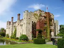
Examples at Grade I include Knole House, Chartwell, Penshurst Place and Chevening House, most of which have their own produce-selling farms. Older with original stone walls are Hever Castle with its 16 acres (6.5 ha)-wooded island in a listed parkland. A folly exists at Lullingstone Castle which is a reconstruction of its gatehouse and separate modern house.[3]
References
- District Council website
- "2011 Census profile: Age and gender profile (unrounded)" (PDF). Kent County Council. Retrieved 28 March 2014.
- Hever CastleHistoric England. "Details from listed building database (1273465)". National Heritage List for England. Retrieved 30 May 2014.