Siloam Springs, Arkansas
Siloam Springs is a city in Benton County, Arkansas, United States. The city shares a border on the Arkansas-Oklahoma state line with the city of West Siloam Springs, Oklahoma, which is within the Cherokee Nation territory. The town was founded in 1882 and was characterized by the purported healing powers of the spring water feeding Sager Creek and trading with nearby Native American tribes. John Brown University (JBU) was founded in 1919 as a private, interdenominational, Christian liberal arts college in the city. Today, Siloam Springs is known for its efforts to preserve and revitalize the city's historic downtown and as a promoter of the arts via Sager Creek Arts Center and the JBU art gallery. The community is located on the western edge of the growing Northwest Arkansas metropolitan area and has had a population increase of 47% to 15,039 between the 2000 and 2010 censuses.[3]
Siloam Springs, Arkansas | |
|---|---|
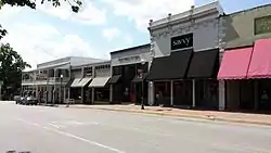
 Clockwise, from top: Gazebo in City Park, Main Street Siloam Springs, fountain in Twin Springs Park, entrance to John Brown University, Sager Creek Arts Center, fountains in Sager Creek | |
 Location of Siloam Springs in Benton County, Arkansas. | |
| Coordinates: 36°11′0″N 94°32′22″W | |
| Country | United States |
| State | Arkansas |
| County | Benton |
| Incorporated | December 22, 1881 |
| Government | |
| • Type | City Administrator |
| • Mayor | John Turner |
| Area | |
| • Total | 11.55 sq mi (29.91 km2) |
| • Land | 11.38 sq mi (29.47 km2) |
| • Water | 0.17 sq mi (0.44 km2) |
| Elevation | 1,132 ft (345 m) |
| Population (2010) | |
| • Total | 15,039 |
| • Estimate (2019)[2] | 17,101 |
| • Density | 1,502.86/sq mi (580.26/km2) |
| Time zone | UTC-6 (Central (CST)) |
| • Summer (DST) | UTC-5 (CDT) |
| ZIP code | 72761 |
| Area code(s) | 479 |
| FIPS code | 05-64370 |
| GNIS feature ID | 0078364 |
| Website | www |
In 2012, the city was named one of the 20 best small towns in America by Smithsonian magazine[4]
History
Osage Indians were the known first inhabitants of the area. Siloam Springs' first white settlers were of German and Scots-Irish origin. Simon Sager is considered the founder of the town, then known as Hico.[3]
Geography

The area is located in the Mid-South region of the country where the southern plains meet the Ozark Mountains. The city sits atop a plateau with many dogwood trees growing across the landscape. Siloam Springs is made up of Siloam Springs, Arkansas, and West Siloam Springs, Oklahoma. The latter is in the territory of the Cherokee Nation in northeastern Oklahoma.
A perennial creek, named after the founder, Sager Creek, flows through the downtown area.
According to the United States Census Bureau, the city has a total area of 11.2 square miles (28.9 km2), of which 11.1 square miles (28.7 km2) is land and 0.077 square miles (0.2 km2), or 0.71%, is water.[5]
Metropolitan area
The Fayetteville–Springdale–Rogers Metropolitan Area consists of three Arkansas counties: Benton, Madison, and Washington, and McDonald County, Missouri.[6] The area had a population of 347,045 at the 2000 census which had increased to 463,204 by the 2010 Census (an increase of 33.47 per cent). Siloam Springs is at the extreme western edge of this area, connected to the principal cities by Highway 412.
Climate
The climate in this area is characterized by hot, humid summers and generally mild to cool winters. According to the Köppen Climate Classification system, Siloam Springs has a humid subtropical climate, abbreviated "Cfa" on climate maps.[7]
July is the hottest month of the year, with an average high of 89.1 °F (31.7 °C) and an average low of 68.6 °F (20.3 °C). Temperatures above 100 °F (37.8 °C) are rare but not uncommon, occurring on average twice a year. January is the coldest month with an average high of 44.3 °F (6.8 °C) and an average low of 24.2 °F (−4.3 °C). Highs below 32 °F (0.0 °C) occur on average thirteen times a year, with 2.2 nights per year dropping below 0 °F (−17.8 °C). The city's highest temperature was 111 °F (43.9 °C), recorded on July 14, 1954. The lowest temperature recorded was −24 °F (−31.1 °C), on February 12, 1899.
Precipitation is weakly seasonal, with a bimodal pattern: wet seasons in the spring and fall, and relatively drier summers and winters, but some rain in all months. The spring wet season is more pronounced than fall, with the highest rainfall in May. This differs slightly from the climate in central Arkansas, where the fall wet season is more comparable to spring.
| Climate data for Siloam Springs, Arkansas (1981–2010 normals) | |||||||||||||
|---|---|---|---|---|---|---|---|---|---|---|---|---|---|
| Month | Jan | Feb | Mar | Apr | May | Jun | Jul | Aug | Sep | Oct | Nov | Dec | Year |
| Record high °F (°C) | 77 (25) |
83 (28) |
90 (32) |
91 (33) |
92 (33) |
103 (39) |
111 (44) |
109 (43) |
102 (39) |
96 (36) |
83 (28) |
79 (26) |
111 (44) |
| Average high °F (°C) | 45 (7) |
51 (11) |
59 (15) |
69 (21) |
76 (24) |
84 (29) |
89 (32) |
89 (32) |
81 (27) |
71 (22) |
57 (14) |
48 (9) |
68 (20) |
| Average low °F (°C) | 23 (−5) |
28 (−2) |
36 (2) |
44 (7) |
53 (12) |
62 (17) |
67 (19) |
66 (19) |
59 (15) |
47 (8) |
36 (2) |
27 (−3) |
46 (8) |
| Record low °F (°C) | −12 (−24) |
−10 (−23) |
−7 (−22) |
20 (−7) |
30 (−1) |
43 (6) |
46 (8) |
42 (6) |
31 (−1) |
20 (−7) |
5 (−15) |
−8 (−22) |
−12 (−24) |
| Average precipitation inches (mm) | 2.27 (58) |
2.20 (56) |
4.32 (110) |
4.31 (109) |
5.20 (132) |
4.84 (123) |
3.54 (90) |
3.35 (85) |
5.05 (128) |
3.68 (93) |
4.82 (122) |
3.42 (87) |
47 (1,193) |
| Average snowfall inches (cm) | 3.3 (8.4) |
1.6 (4.1) |
1.9 (4.8) |
0 (0) |
0 (0) |
0 (0) |
0 (0) |
0 (0) |
0 (0) |
0.1 (0.25) |
0.2 (0.51) |
2.0 (5.1) |
9.1 (23.16) |
| Source: The Weather Channel[8] | |||||||||||||
Demographics
| Historical population | |||
|---|---|---|---|
| Census | Pop. | %± | |
| 1880 | 95 | — | |
| 1890 | 821 | 764.2% | |
| 1900 | 1,748 | 112.9% | |
| 1910 | 2,405 | 37.6% | |
| 1920 | 2,569 | 6.8% | |
| 1930 | 2,378 | −7.4% | |
| 1940 | 2,764 | 16.2% | |
| 1950 | 3,270 | 18.3% | |
| 1960 | 3,953 | 20.9% | |
| 1970 | 6,009 | 52.0% | |
| 1980 | 7,940 | 32.1% | |
| 1990 | 8,151 | 2.7% | |
| 2000 | 10,843 | 33.0% | |
| 2010 | 15,039 | 38.7% | |
| 2019 (est.) | 17,101 | [2] | 13.7% |
| U.S. Decennial Census[9] | |||
As of the census[10] of 2010, there were 15,039 people in 5,138 households with 93.3% of the population in households. The racial and ethnic composition of the population was 76% non-Hispanic white, 0.8% black, 4.6% Native American, 1.6% Asian, 0.2% non-Hispanic reporting some other race, 5.0% from two or more races and 20.8% Hispanic or Latino.[11]
At the 2000 census, there were 2,647 families residing in the city. The population density was 1,027.2 per square mile (396.4/km2). There were 4,223 housing units at an average density of 400.1 per square mile (154.4/km2). The racial makeup of the city was 85.22% White, 0.49% Black or African American, 4.29% Native American, 0.83% Asian, 0.08% Pacific Islander, 5.67% from other races, and 3.42% from two or more races. 14.00% of the population were Hispanic or Latino of any race.
There were 3,894 households, out of which 34.8% had children under the age of 18 living with them, 53.8% were married couples living together, 10.6% had a female householder with no husband present, and 32.0% were non-families. 26.9% of all households were made up of individuals, and 11.9% had someone living alone who was 65 years of age or older. The average household size was 2.57 and the average family size was 3.11.
In the city, the population was spread out, with 26.0% under the age of 18, 16.8% from 18 to 24, 27.8% from 25 to 44, 17.1% from 45 to 64, and 12.3% who were 65 years of age or older. The median age was 30 years. For every 100 females, there were 95.6 males. For every 100 females age 18 and over, there were 91.2 males.
The median income for a household in the city was $34,513, and the median income for a family was $41,153. Males had a median income of $27,339 versus $21,451 for females. The per capita income for the city was $16,047. About 9.5% of families and 12.5% of the population were below the poverty line, including 17.6% of those under age 18 and 8.6% of those age 65 or over.
As of 2009, there were 52 churches that called Siloam Springs home by address. There are reports that Siloam Springs has a record for most number churches per capita, and while the ratio is higher than average, it has never been verified through reliable documentation. (Despite the large number of churches, the town does contain a small atheist/non-religious community.) Major employers in Siloam Springs include Simmons Foods,[12] Gates Corporation, La-Z-Boy, DaySpring (a subsidiary of Hallmark Cards).Sager Creek Veggie ie Allens Canning, ie Delmonte veggies have closed.[13]
Arts and culture
Annual cultural events
| Event | Time of year | Attendance (approx.) |
|---|---|---|
| Dogwood Festival | April (last weekend) | 30,000 |
| Homegrown Festival | October | 3,000 |
| Siloam Springs Rodeo | June | 10,000 |
| Christmas Parade | December (first Saturday) | 6,500 |
| City Fireworks Presentation | July 4 | 6,000 |
| Northwest Arkansas Marching Band Invitational | October | 2,500 |
| JBU Candlelight Christmas Concerts | December | 3,000 |
| JBU Homecoming | October | 1,000 |
| Siloam Springs Music Games (Marching Band Competition) | July | 2,000 |
| Sager Creek Arts Center | All year | 10,000 per year |
Government
Siloam Springs has a City Administrator form of government. The government body consists of the Mayor, Board of Directors and District Judge. All positions are chosen by election. The other officials and commissioners are appointed with Board approval.
Education

In addition to John Brown University, public education is supported by the Siloam Springs School District consisting of:
- Siloam Springs High School (grades 9-12)
- Siloam Springs Middle School (grades 7-8)
- Siloam Springs Intermediate School (grades 5-6)
- Southside Elementary School (grades 3-4)
- Allen Elementary School (grades 1 & 2)
- Northside Elementary School (grades Pre-K & K)
Infrastructure
Transportation
Siloam Springs traffic is primarily served by US 412 (US 412) for east-west travel, connecting the city to Tulsa, Oklahoma, to the west via the Cherokee Turnpike and to Bentonville, Fayetteville, and Springdale, Arkansas, to the east. US 59 runs south from West Siloam Springs to Stilwell and Sallisaw, Oklahoma, while Arkansas 59 runs north to Gravette and south to Van Buren and Fort Smith, Arkansas. Within the city, major routes include Cheri Whitlock Drive, Lincoln Street, Main Street, Mount Olive Street, and University Street.
Smith Field, located east of town, serves small business jets as well as double- and single-engine aircraft. It serves exclusively general aviation operations.
Utilities
The city's primary water source is the Illinois River, although some water is purchased from Benton - Washington Regional Public Water Authority, whose source is Beaver Lake.[14] The water is treated with chlorine, and the by-products of this chlorination process are kept compliant with the Arkansas Department of Health standards. Fluoride is added to supplement the naturally occurring amount present prior to treatment.
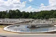
Wastewater is treated at the Siloam Springs Wastewater Treatment Plant (SSWWTP). Since effluent is discharged into a tributary of the Illinois, the plant's effluent is required to meet the treatment standards of both Arkansas and Oklahoma. The phosphorus load of the Illinois has been subject of controversy in the area, even reaching the United States Supreme Court in 1992. The Environmental Protection Agency (EPA) has classified the Illinois as Section 303(d) of the Clean Water Act, listing it as an "impaired and threatened water" due to the high phosphorus loads.[15] As a result of the applicable strict phosphorus effluent regulations, SSWWTP upgraded its system in 2011. The upgrades also increased capacity 25% to 5.5 million gallons per day (MGD) (14,474 liters per hour).[16] Although presently a traditional biological nutrient removal (BNR) plant capable of meeting the interim phosphorus limit, pilot tests have proven a chemical nutrient removal (CNR) and membrane biological reactor combination to be effective well below the possible future permit limit. However, due to the high cost, these phases have been delayed. Currently, a 3-year study is being conducted to determine the background phosphorus level in the Illinois. The future effluent limits will likely be written following the conclusion of the study. An EPA Total maximum daily load (TMDL) study in the watershed is also ongoing.[17]
Notable people
- Duncan Baird, Republican state representative from District 96 in Benton County, graduated from Siloam Springs High School; he was a Republican candidate for Arkansas state treasurer in 2014.
- Jonathan Barnett, Republican state representative from District 87 in Benton and Washington counties, former member of the Siloam Springs City Council; general contractor.
- Preston Bynum, a lobbyist in Little Rock, served as the state representative from Siloam Springs from 1969 to 1980. He was the second Republican to represent Benton County in the legislature in the 20th century, the first having been Jim Sheets. He also served from 1981 to 1983 as chief of staff to Governor Frank White.
- Mike Flynn, radio personality; host of the NPR program The Folk Sampler, a one-hour program of traditional folk music that originates from Siloam Springs.
- Alice Ghostley, an actress, spent a number of years in Siloam Springs as a youth.
- Justin Harris, member of the Arkansas House of Representatives from Washington and Crawford counties; raised in Siloam Springs and graduated from high school there.
- Mathew Pitsch, Republican member of the Arkansas House of Representatives from Fort Smith since 2015; adjunct professor at John Brown University[18]
- Jim Winn, Major League Baseball pitcher, went to John Brown University in Siloam Springs.
- Jon Woods, Jonathan Earl Woods (born August 23, 1977, in Charlotte, North Carolina), is a Republican former member of both houses of the Arkansas General Assembly and is a record producer and musician. "Jonathan Earl Woods".
See also
 United States portal
- Arkansas Highway 99, a former highway designation in Siloam Springs
References
- "2019 U.S. Gazetteer Files". United States Census Bureau. Retrieved June 30, 2020.
- "Population and Housing Unit Estimates". United States Census Bureau. May 24, 2020. Retrieved May 27, 2020.
- Warden, Don (March 1, 2012). "Siloam Springs (Benton County)". Encyclopedia of Arkansas History and Culture. Butler Center for Arkansas Studies at the Central Arkansas Library System. Retrieved August 16, 2013.
- "The 20 Best Small Towns in America of 2012".
- "Geographic Identifiers: 2010 Demographic Profile Data (G001): Siloam Springs city, Arkansas". U.S. Census Bureau, American Factfinder. Archived from the original on February 12, 2020. Retrieved September 23, 2013.
- "Update of Statistical Area Definitions and Guidance on Their Uses" (PDF). Executive office of the President Office of Management and Budget. December 1, 2009. p. 32. Archived from the original (PDF) on March 16, 2012. Retrieved January 13, 2013.
- "Siloam Springs, Arkansas Köppen Climate Classification (Weatherbase)". Weatherbase.
- "Monthly Averages for Siloam Springs, AR" (Table). The Weather Channel. Retrieved September 13, 2014.
- "Census of Population and Housing". Census.gov. Retrieved June 4, 2015.
- "U.S. Census website". United States Census Bureau. Retrieved 2008-01-31.
- 2010 general profile of population and housing characteristics for Siloam Springs from the US census
- Wilson, Kristen. "Simmons Foods facility creating new jobs in Siloam Springs". KATV. Retrieved 2018-04-10.
- That company has been closed and isnt there
- "Annual Drinking Water Quality Report". Siloam Springs Water Department. 2012. Missing or empty
|url=(help) - "Illinois River Watershed". Environmental Protection Agency. May 22, 2013. Retrieved July 21, 2013.
- Hetzel, Jon (February 2007). "Arkansas wastewater treatment plant pilots path to fledgling technology". APWA. Retrieved July 20, 2013.
- "Oklahoma Attorney General's Office, Arkansas AG Sign Illinois River Agreement". State of Oklahoma Attorney General's Office. February 20, 2013. Retrieved December 10, 2013.
- "Mathew W. Pitsch". ciclt.net. Retrieved April 10, 2015.
External links
Municipalities and communities of Benton County, Arkansas, United States | ||
|---|---|---|
| Cities | 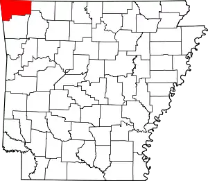 Map of Arkansas highlighting Benton County | |
| Towns | ||
| Townships | ||
| CDPs | ||
| Other communities |
| |
| Ghost towns | ||
| Footnotes | ‡This populated place also has portions in an adjacent county or counties | |
| ||
| Authority control |
|---|