Sirohi
Sirohi is a city in southern Rajasthan state in western India. It is the administrative headquarters of Sirohi District and was formerly the capital of the princely state of Sirohi ruled by Sirohi Rajput rulers. The nearest railway station to Sirohi is Sirohi Road. Sirohi got first rank in 33 districts of Rajasthan for "Swachha Bharat Abhiyaan” in year 2014.
Sirohi
Hirohi Devnagri | |
|---|---|
City | |
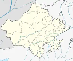 Sirohi Location in Rajasthan, India  Sirohi Sirohi (India) | |
| Coordinates: 24.885°N 72.8625°E | |
| Country | |
| State | Rajasthan |
| District | Sirohi |
| Founded | aft. 1450 |
| Founded by | Rao Sobhaji, Sehastramal |
| Government | |
| • Type | Rajasthan Government |
| • Body | Municipal Council / Nagar Parishad, Sirohi |
| • MP | Devji M Patel |
| • MLA | Sanyam Lodha |
| Area | |
| • Total | 5,179 km2 (2,000 sq mi) |
| Elevation | 321 m (1,053 ft) |
| Population (2012) | |
| • Total | 851,107 |
| • Density | 164/km2 (420/sq mi) |
| Demonym(s) | Sirohian |
| Languages | |
| • Official | Hindi |
| • Local | Rajasthani |
| Time zone | UTC+5:30 (IST) |
| PIN | 307001 |
| Telephone code | 02972 |
| Vehicle registration | RJ-24 |
| Nearest city | Ahmedabad, Jalore, Pali, Barmer, Mehsana, Udaipur, Reodar, Abu Road, Pindwara |
| Avg. summer temperature | 42 °C (108 °F) |
| Avg. winter temperature | 6 °C (43 °F) |
| Website | http://sirohi.rajasthan.gov.in/ |
Geography
Sirohi is located at 24.885°N 72.8625°E.[1] It has an average elevation of 321 metres (1053 ft).
History
In 1405, Rao Sobhaji founded the town of Shivpuri on the eastern slope of Siranwa Hill. Shivpuri today lies in ruins.[2] In 1425, Sobhaji's son and successor, Sehastramal (or Sainsmal), founded a fortress on the eastern slope of the same hill, which became his capital and grew into the present-day town of Sirohi.[2]
After Independence an agreement was signed between Central Government and minor ruler of Sirohi State, with this the State Administration of the Sirohi State was taken over by Bombay Government from 5 January 1949 to 25 January 1950. The first administrator representing a bombay state was Prema Bhai Patel. After final merger with Rajasthan in 1950, an area of 787 km2 consisting of Aburoad and Delwara tehsils of Sirohi district was renamed with the Bombay State on 1 November 1956, after the recommendation of the State organisation Commission, which forms the present position of the district.
Education
Schools in Sirohi are affiliated either by the Central board of secondary education, or Rajasthan board of secondary education. There are 863 schools in the district including both private and government. The higher education institutions in the city included Govt P.G. College affiliated by Mohanlal Sukhadia University, a Govt. Girls College which is also affiliated to Mohanlal Sukhadia University, Udaipur and & Private colleges. For technical education Govt. Polytechnic & Govt. Women B.Ed college and ITI college as well.
Some renowned schools in the city are St. Paul's Higher Secondary School, Ajit Vidhya Mandir and Emmanuel Mission School.
National and State highways
Sirohi is well connected to highways of India by the NHAI. NH 62 connects sirohi from South starting from Pindwara to the north up to the Pali District of Rajasthan and continues up to Beawar. NH 168 passing through Sirohi intersecting SH 27 which is also known as Delhi - Kandla Highway SH 27 ends at Deesa In Gujarat State. SH 38 passing from NH 62 in the west of the Sirohi connecting NH 112 via Jalore and ends at the Balotra in Barmer District. SH 10 on the east of Sirohi heading towards NH 8 intersect at Udaipur, Rajasthan and SH 10 continues up to Banswara District in Rajasthan.
See also
Notes
- Falling Rain Genomics, Inc - Sirohi
- Adams, Archibald (1899). A medico-topographical and general account of Marwar, Sirohi, and Jaisalmir. Junior Army and Navy Stores.
References
- Chisholm, Hugh, ed. (1911). . Encyclopædia Britannica. 25 (11th ed.). Cambridge University Press. p. 257.
- Cahoon, Ben (2000), Indian princely states, WorldStatesmen, retrieved April 2013 Check date values in:
|access-date=(help) — also shows the state's flag - P.R.O. Sirohi (15 April 2013), Sirohi district web site, National Informatics Centre, Government of India, District Unit-Sirohi, archived from the original on 1 April 2013, retrieved April 2013 Check date values in:
|access-date=(help) - Temples of Sirohi, archived from the original on 18 November 2012
External links
- Indian Princely States- Genealogy of the ruling chiefs of Sirohi, archived from the original on 17 February 2005
| Outline |
|  | |||||||||||||
|---|---|---|---|---|---|---|---|---|---|---|---|---|---|---|---|
| Governance |
| ||||||||||||||
| Divisions and districts |
| ||||||||||||||
| Major cities | |||||||||||||||
| Related templates |
| ||||||||||||||
