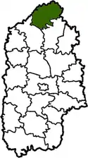
Slavuta Raion
Slavuta Raion (Ukrainian: Славутський район) was a raion of Khmelnytskyi Oblast in Ukraine. Its administrative center was Slavuta which was incorporated separately as city of oblast significance and did not belong to the raion. It was established in 1923. 79 villages were located in Slavuta Raion. The raion was abolished on 18 July 2020 as part of the administrative reform of Ukraine, which reduced the number of raions of Khmelnytskyi Oblast to three.[1][2] The last estimate of the raion population was 28,018 (2020 est.)[3]
Slavuta Raion
Славутський район | |
|---|---|
 Flag  Coat of arms | |
 | |
| Coordinates: 50°23′32″N 26°56′58″E | |
| Country | |
| Region | Khmelnytskyi Oblast |
| Established | 1923, 1959 |
| Disestablished | 18 July 2020 |
| Admin. center | Slavuta |
| Subdivisions | List
|
| Government | |
| • Governor | Vasyl V. Kardash |
| Area | |
| • Total | 1,162 km2 (449 sq mi) |
| Population (2020) | |
| • Total | 28,018 |
| • Density | 24/km2 (62/sq mi) |
| Time zone | UTC+02:00 (EET) |
| • Summer (DST) | UTC+03:00 (EEST) |
| Postal index | 30014—30087 |
| Area code | 380-3842 |
| Website | www |
Geography
Slavuta Raion was a part of Volhynia. It was one out 20 Raions of Khmelnytskyi Oblast. It was a large raion and ranked as the 7th among the largest with respect to the total area (1 162 km² corresponding to 5.6% of the total area of Khmelnytskyi Oblast).
Slavuta Raion was southeast of Rivne Oblast (Ostroh Raion, Hoshcha Raion and Korets Raion), southwest of Zhytomyr Oblast (Novohrad-Volynskyi Raion and Baranivka Raion), northwest of Shepetivka Raion, and northeast of Iziaslav Raion. The Horyn, Korchyk, Tsvitoha and other rivers flowed through the district. There was a rail line through the district (Shepetivka—Zdolbuniv).
History
From 1923 to 1932 the district was part of Shepetivka region, then from 1932 to 1937 it was part of the Vinnytsia Oblast. Following that from 1937 to 1954 it was part of Kamenets Podolsk region. Since 1954 it has been part of Khmelnytskyi Oblast. Finally Slavuta Raion was formed September 23, 1959.
References
- "Про утворення та ліквідацію районів. Постанова Верховної Ради України № 807-ІХ". Голос України (in Ukrainian). 2020-07-18. Retrieved 2020-10-03.
- "Нові райони: карти + склад" (in Ukrainian). Міністерство розвитку громад та територій України.
- "Чисельність наявного населення України (Actual population of Ukraine)" (PDF) (in Ukrainian). State Statistics Service of Ukraine. Retrieved 30 September 2020.
External links
- www.slavuta-rda.com/ (in Ukrainian)
 Media related to Slavutsky Raion at Wikimedia Commons
Administrative geographic location | |
|---|---|
| Raions | |||||
|---|---|---|---|---|---|
| Hromadas | |||||
| Cities |
| ||||
| |||||
| Authority control |
|
|---|