Slippery Rock Creek
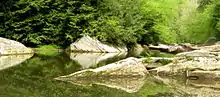
Slippery Rock Creek[1] is a small stream in Western Pennsylvania, a tributary of Connoquenessing Creek. From its source in Hilliards in Butler County, it flows through McConnells Mill State Park before flowing into the Connoquenessing in Ellwood City. Then, the Connoquenessing flows into the Beaver River just three miles south from the mouth of Slippery Rock.
| Slippery Rock Creek | |
|---|---|
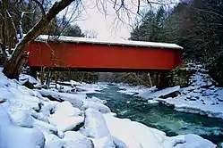 Slippery Rock Creek passes under the covered bridge at McConnells Mill State Park. | |
 Location of Slippery Rock Creek mouth  Slippery Rock Creek (the United States) | |
| Location | |
| Country | United States of America |
| State | Pennsylvania |
| County | Butler Lawrence |
| Cities | Slippery Rock, PA, Ellwood City, PA |
| Physical characteristics | |
| Source | |
| • location | Hilliards, Butler County, Pennsylvania |
| • coordinates | 41°06′51″N 79°48′15″W[1] |
| • elevation | 1,400 ft (430 m)[2] |
| Mouth | Connoquenessing Creek |
• location | Ellwood City, Beaver County, Pennsylvania |
• coordinates | 40°51′31″N 80°15′24″W |
• elevation | 810 ft (250 m)[1] |
| Length | 50.17 mi (80.74 km)[3] |
| Basin size | 409.79 square miles (1,061.4 km2)[4] |
| Discharge | |
| • average | 611.19 cu ft/s (17.307 m3/s) at mouth with Connoquenessing Creek[5] |
| Basin features | |
| Progression | southwest |
| River system | Beaver River |
| Tributaries | |
| • left | South Branch Glade Run Big Run Hogue Run Black Run Muddy Creek Cheeseman Run Grindstone Run |
| • right | Seaton Creek Blacks Creek North Branch McMurray Run McDonald Run Long Run Wolf Creek Jamison Run Taylor Run Hell Run Skunk Run |
Slippery Rock Creek is a favorite for whitewater kayakers and canoeists from Pittsburgh and Ohio. With Class-II and -III rapids and engaging beauty, it attracts regular paddlers from novice to advanced level. Slippery Rock Creek, however, can be very dangerous. The rocks are indeed deceptively slippery, and throughout the year, there are numerous reports of drowning incidents, mostly near the McConnells Mill State Park.[6]
Watershed
Tributaries
| Name, Bank[7] | River Mile (km)[8] | Watershed Area in Square Miles (km2)[9] | Average Discharge[9] | Mouth Coordinates[10] | Mouth Elevation[7] | Source Coordinates[10] | Source Elevation[7] | Remarks |
|---|---|---|---|---|---|---|---|---|
| Mouth | 409.79 square miles (1,061.4 km2) | 611.19 cu ft/s (17.307 m3/s) | 40°51′31″N 80°15′24″W | 810 ft (250 m) | 41°06′51″N 79°48′15″W | 1,400 ft (430 m) | Slippery Rock Creek enters Connoquenessing Creek at Wurtemburg, Pennsylvania in Wayne and Perry Townships (Lawrence County). | |
| Skunk Run, right bank | 4.42 mi (7.11 km) | 1.86 square miles (4.8 km2) | 2.35 cu ft/s (0.067 m3/s) | 40°54′11″N 80°13′31″W | 870 ft (270 m) | 40°55′21″N 80°15′53″W | 1,260 ft (380 m) | Skunk Run enters Slippery Rock Creek in Wayne Township, Lawrence County. |
| Hell Run, right bank | 5.52 mi (8.88 km) | 5.78 square miles (15.0 km2) | 7.24 cu ft/s (0.205 m3/s) | 40°54′57″N 80°12′55″W | 880 ft (270 m) | 40°56′02″N 80°15′48″W | 1,220 ft (370 m) | Hell Run enters Slippery Rock Creek in Slippery Rock Township, Lawrence County, Pennsylvania within McConnells Mill State Park. It is the only Exceptional Value (EV) classified stream in Lawrence County. |
| Grindstone Run, left bank | 6.44 mi (10.36 km) | 1.0 square mile (2.6 km2) | 1.32 cu ft/s (0.037 m3/s) | 40°55′13″N 80°12′01″W | 920 ft (280 m) | 40°54′28″N 80°10′49″W | 1,260 ft (380 m) | Grindstone Run enters Slippery Rock Creek in Perry Township, Lawrence County, Pennsylvania within McConnells Mill State Park. |
| Cheeseman Run, left bank | 8.4 mi (13.5 km) | 2.4 square miles (6.2 km2) | 3.20 cu ft/s (0.091 m3/s) | 40°56′19″N 80°10′43″W | 940 ft (290 m) | 40°55′22″N 80°08′52″W | 1,275 ft (389 m) | Cheeseman Run rises in Muddy Creek Township of Butler County and flows west into Perry Township of Lawrence County. |
| Muddy Creek, left bank | 11.82 mi (19.02 km) | 80.66 square miles (208.9 km2) | 80.66 cu ft/s (2.284 m3/s) | 40°58′48″N 80°10′46″W | 1,040 ft (320 m) | 40°59′29″N 79°52′31″W | 1,370 ft (420 m) | Muddy Creek rises in western Butler County and flows west into eastern Lawrence County, Pennsylvania. Lake Arthur is a prominent impoundment of this stream. Muddy Creek is the second largest tributary by average discharge. |
| Taylor Run, right bank | 16.66 mi (26.81 km) | 12.96 square miles (33.6 km2) | 17.9 cu ft/s (0.51 m3/s) | 41°01′44″N 80°09′28″W | 1,075 ft (328 m) | 41°07′15″N 80°10′24″W | 1,340 ft (410 m) | Taylor Run rises in southwestern Mercer County and flows south to Lawrence County, Pennsylvania, where it joins Slippery Rock Creek. |
| Jamison Run, right bank | 18.06 mi (29.06 km) | 12.76 square miles (33.0 km2) | 18.01 cu ft/s (0.510 m3/s) | 41°01′58″N 80°08′26″W | 1,085 ft (331 m) | 41°06′34″N 80°09′28″W | 1,250 ft (380 m) | Jamison Run rises in Lawrence County, Pennsylvania and flows south into Slippery Rock Creek. |
| Black Run, left bank | 18.90 mi (30.42 km) | 7.67 square miles (19.9 km2) | 10.83 cu ft/s (0.307 m3/s) | 41°01′29″N 80°07′55″W | 1,090 ft (330 m) | 40°00′26″N 80°04′48″W | 1,195 ft (364 m) | Black Run originates in a wetland upstream of Tamarack Lake and then flows northwest to meet Slippery Rock Creek at Elliotts Mills, Pennsylvania. |
| Wolf Creek, right bank | 21.28 mi (34.25 km) | 102.86 square miles (266.4 km2) | 145.08 cu ft/s (4.108 m3/s) | 41°02′28″N 80°06′06″W | 1,100 ft (340 m) | 41°17′43″N 80°05′12″W | 1,360 ft (410 m) | Wolf Creek originates in Pine Swamp in Mercer County and then flows south to meet Slippery Rock Creek at Moores Corners, Pennsylvania. Wolf Creek is the largest tributary by average discharge. |
| Hogue Run, left bank | 23.76 mi (38.24 km) | 7.41 square miles (19.2 km2) | 10.70 cu ft/s (0.303 m3/s) | 41°01′44″N 80°04′20″W | 1,100 ft (340 m) | 40°59′04″N 80°05′51″W | 1,320 ft (400 m) | Hogue Run rises near Shawood Park, Pennsylvania and then flows north to meet Slippery Rock Creek near Camp Crestview. |
| Big Run, left bank | 26.94 mi (43.36 km) | 7.14 square miles (18.5 km2) | 10.36 cu ft/s (0.293 m3/s) | 41°01′14″N 80°02′07″W | 1,130 ft (340 m) | 40°59′14″N 79°59′14″W | 1,370 ft (420 m) | Big Run rises near Elora, Pennsylvania and then flows northwest to meet Slippery Rock Creek near Crolls Mills. |
| Glade Run, left bank | 30.32 mi (48.80 km) | 7.62 square miles (19.7 km2) | 11.12 cu ft/s (0.315 m3/s) | 41°01′30″N 80°00′50″W | 1,148 ft (350 m) | 40°59′04″N 79°56′42″W | 1,370 ft (420 m) | Glade Run rises near Euclid, Pennsylvania and then flows northwest to meet Slippery Rock Creek at Slippery Rock Park. |
| Long Run, right bank | 32.40 mi (52.14 km) | 3.8 square miles (9.8 km2) | 5.77 cu ft/s (0.163 m3/s) | 41°02′59″N 80°00′15″W | 1,150 ft (350 m) | 41°06′03″N 80°01′16″W | 1,350 ft (410 m) | Long Run rises near Adams Corners, Pennsylvania and then flows south to meet Slippery Rock Creek at Camp Bucoco. |
| McDonald Run, right bank | 34.78 mi (55.97 km) | 4.02 square miles (10.4 km2) | 6.07 cu ft/s (0.172 m3/s) | 41°03′39″N 79°59′16″W | 1,160 ft (350 m) | 41°06′29″N 80°00′40″W | 1,330 ft (410 m) | McDonald Run rises in Forestville, Pennsylvania and then flows south to meet Slippery Rock Creek south of Branchton. |
| South Branch Slippery Rock Creek, left bank | 35.32 mi (56.84 km) | 39.49 square miles (102.3 km2) | 55.78 cu ft/s (1.580 m3/s) | 41°03′33″N 79°58′47″W | 1,165 ft (355 m) | 40°59′58″N 79°48′58″W | 1,320 ft (400 m) | Suth Branch of Slippery Rock Creek rises east of Hooker, Pennsylvania and then flows northwest to meet Slippery Rock Creek south of Bovard, Pennsylvania. |
| McMurray Run, right bank | 37.58 mi (60.48 km) | 13.29 square miles (34.4 km2) | 19.60 cu ft/s (0.555 m3/s) | 41°04′38″N 79°57′55″W | 1,175 ft (358 m) | 41°09′32″N 80°00′23″W | 1,390 ft (420 m) | McMurray Run rises north of Harrisville, Pennsylvania and flows south to meet Slippery Rock Creek at Rock Hill Camp. This run drains most of Harrisville. |
| North Branch Slippery Rock Creek, right bank | 40.74 mi (65.56 km) | 16.17 square miles (41.9 km2) | 24.28 cu ft/s (0.688 m3/s) | 41°05′53″N 79°55′49″W | 1,180 ft (360 m) | 41°11′53″N 79°58′57″W | 1,378 ft (420 m) | North Branch Slippery Rock Creek rises in Barkeyville, Pennsylvania and then flows south to meet Slippery Rock Creek near Atwells Crossing, Pennsylvania. |
| Blacks Creek, right bank | 42.26 mi (68.01 km) | 8.75 square miles (22.7 km2) | 13.42 cu ft/s (0.380 m3/s) | 41°06′41″N 79°54′56″W | 1,190 ft (360 m) | 41°10′33″N 79°55′17″W | 1,420 ft (430 m) | Blacks Creek rises south of Nectarine, Pennsylvania and then flows south to meet Slippery Rock Creek west of Boyers, Pennsylvania. |
| Seaton Creek, right bank | 43.90 mi (70.65 km) | 10.42 square miles (27.0 km2) | 16.16 cu ft/s (0.458 m3/s) | 41°06′43″N 79°53′26″W | 1,195 ft (364 m) | 41°08′05″N 79°48′40″W | 1,480 ft (450 m) | Seaton Creek rises west of Eau Claire, Pennsylvania and then flows southwest to meet Slippery Rock Creek at Boyers, Pennsylvania. |
See also
References
- U.S. Geological Survey Geographic Names Information System: Slippery Rock Creek
- "Whiskerville Topo Map, Butler County PA (Hilliards Area)". TopoZone. Locality, LLC. Retrieved 28 July 2019.
- "ArcGIS Web Application". epa.maps.arcgis.com. US EPA. Retrieved 28 July 2019.
- "Slippery Rock Watershed Report". Waters Geoviewer. US EPA. Retrieved 28 July 2019.
- "Slippery Rock Creek Watershed Report". Waters Geoviewer. US EPA. Retrieved 28 July 2019.
- Watson, Wyndle (November 13, 1996). "Dream stream". Pittsburgh Post-Gazette. pp. C4. Retrieved 3 May 2015.
- "Slippery Rock Creek Topo Map, Lawrence County PA (Beaver Falls Area)". TopoZone. Locality, LLC. Retrieved 24 August 2019.
- "Pennsylvania Gazetteer of Streams" (PDF). PA DEP and US Geological Survey. Retrieved 24 August 2019.
- "ArcGIS Web Application". epa.maps.arcgis.com. US EPA. Retrieved 24 August 2019.
- "GNIS Feature Search". geonames.usgs.gov. US Geological Survey. Retrieved 24 August 2019.
External links
- U.S. Geological Survey: PA stream gaging stations
- National Whitewater River Inventory: Slippery Rock Creek (Upper)
- National Whitewater River Inventory: Slippery Rock Creek (Lower)
- Slippery Rock Watershed Coalition