Slippery Rock Township, Lawrence County, Pennsylvania
Slippery Rock Township is a township in Lawrence County, Pennsylvania, United States. As of the 2010 census, the population was 3,283.[5]
Slippery Rock Township | |
|---|---|
 | |
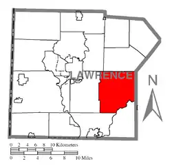 Location of Slippery Rock Township in Lawrence County | |
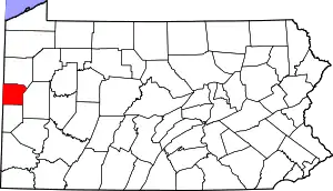 Location of Lawrence County in Pennsylvania | |
| Country | United States |
| State | Pennsylvania |
| County | Lawrence County |
| Established | 1813 |
| Area | |
| • Total | 30.07 sq mi (77.87 km2) |
| • Land | 29.85 sq mi (77.32 km2) |
| • Water | 0.21 sq mi (0.55 km2) |
| Highest elevation [2] (Shaffer Road) | 1,440 ft (440 m) |
| • Rank | highest point in Lawrence County |
| Lowest elevation | 880 ft (270 m) |
| Population (2010) | |
| • Total | 3,283 |
| • Estimate (2018)[3] | 3,110 |
| • Density | 105.59/sq mi (40.77/km2) |
| Time zone | UTC-4 (EST) |
| • Summer (DST) | UTC-5 (EDT) |
| Area code(s) | 724 |
| Website | slipperyrocktownship |
| Historical population | |||
|---|---|---|---|
| Census | Pop. | %± | |
| 2000 | 3,179 | — | |
| 2010 | 3,283 | 3.3% | |
| 2018 (est.) | 3,110 | [3] | −5.3% |
| U.S. Decennial Census[4] | |||
History
The township was linked to New Castle, Ellwood City and Pittsburgh in 1908 by the Pittsburgh, Harmony, Butler and New Castle Railway, an interurban trolley line. The line closed on 15 June 1931, and the trolleys were replaced by buses.
McConnell's Mill Covered Bridge was listed on the National Register of Historic Places in 1980.[6]
Geography
According to the United States Census Bureau, the township has a total area of 30.2 square miles (78.2 km2), of which 30.1 square miles (78.0 km2) is land and 0.1 square miles (0.3 km2), or 0.26%, is water.[7] Unincorporated communities in the township include Princeton, Princeton Station, Kennedy Mill, Grant City, Rose Point, McConnells Mill, and part of Energy.
Located within Slippery Rock Township is McConnells Mill State Park along the Slippery Rock Creek Gorge.
Demographics
As of the census[8] of 2000, there were 3,179 people, 1,203 households, and 916 families residing in the township. The population density was 105.5 people per square mile (40.7/km2). There were 1,285 housing units at an average density of 42.7/sq mi (16.5/km2). The racial makeup of the township was 99.18% White, 0.06% African American, 0.19% Native American, 0.13% Asian, 0.13% from other races, and 0.31% from two or more races. Hispanic or Latino of any race were 0.38% of the population.
There were 1,203 households, out of which 34.2% had children under the age of 18 living with them, 66.6% were married couples living together, 6.7% had a female householder with no husband present, and 23.8% were non-families. 20.5% of all households were made up of individuals, and 9.4% had someone living alone who was 65 years of age or older. The average household size was 2.64 and the average family size was 3.06.
In the township the population was spread out, with 25.2% under the age of 18, 7.1% from 18 to 24, 27.8% from 25 to 44, 26.5% from 45 to 64, and 13.4% who were 65 years of age or older. The median age was 39 years. For every 100 females, there were 98.7 males. For every 100 females age 18 and over, there were 99.7 males.
The median income for a household in the township was $38,651, and the median income for a family was $43,382. Males had a median income of $35,192 versus $21,458 for females. The per capita income for the township was $16,160. About 4.5% of families and 5.8% of the population were below the poverty line, including 5.2% of those under age 18 and 9.4% of those age 65 or over.
References
- "2016 U.S. Gazetteer Files". United States Census Bureau. Retrieved Aug 14, 2017.
- "Slippery Rock Creek Gorge Topo Map, Lawrence County PA (Portersville Area)". TopoZone. Locality, LLC. Retrieved 5 September 2019.
- Bureau, U. S. Census. "U.S. Census website". United States Census Bureau. US Census Bureau. Retrieved 5 September 2019.
- "Census of Population and Housing". Census.gov. Retrieved June 4, 2016.
- "Profile of General Population and Housing Characteristics: 2010 Demographic Profile Data (DP-1): Slippery Rock township, Lawrence County, Pennsylvania". United States Census Bureau. Retrieved March 28, 2012.
- "National Register Information System". National Register of Historic Places. National Park Service. July 9, 2010.
- "US Gazetteer files: 2010, 2000, and 1990". United States Census Bureau. 2011-02-12. Retrieved 2011-04-23.
- "U.S. Census website". United States Census Bureau. Retrieved 2008-01-31.
External links
Municipalities and communities of Lawrence County, Pennsylvania, United States | ||
|---|---|---|
| City | | |
| Boroughs | ||
| Townships | ||
| CDPs | ||
| Unincorporated communities | ||
| Footnotes | ‡This populated place also has portions in an adjacent county or counties | |
| ||
| Counties |  Map of the Pittsburgh Tri-State with green counties in the metropolitan area and yellow counties in the combined area | |
|---|---|---|
| Major cities | ||
| Cities and towns 15k–50k (in 2010) | ||
| Airports | ||
| Topics | ||
| ||
| Authority control |
|
|---|