South Carolina Highway 781
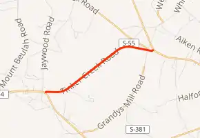
South Carolina Highway 781 (SC 781) is a 3.561-mile (5.731 km) primary state highway in the U.S. state of South Carolina. It is used as part of a bypass south of Aiken, between Augusta and Williston, in conjunction with U.S. Route 278 (US 278).
| ||||
|---|---|---|---|---|
| Tinker Creek Road | ||||
| ||||
| Route information | ||||
| Maintained by SCDOT | ||||
| Length | 3.561 mi[1] (5.731 km) | |||
| Existed | 1940–present | |||
| Major junctions | ||||
| West end | ||||
| East end | ||||
| Location | ||||
| Counties | Aiken | |||
| Highway system | ||||
| ||||

History
Established in 1940 as a new primary route, it traversed from SC 28 in Beech Island east to US 78 west of Williston. In 1953, SC 781 was truncated to its current western terminus, replaced by a rerouted SC 28 (later became US 278 in 1965).[3][4]
Major intersections
The entire highway is in Aiken County.
| Location | mi[1] | km | Destinations | Notes | |
|---|---|---|---|---|---|
| | 0.000 | 0.000 | Western terminus | ||
| White Pond | 3.561 | 5.731 | Eastern terminus | ||
| 1.000 mi = 1.609 km; 1.000 km = 0.621 mi | |||||
See also
 United States portal
 U.S. roads portal
References
- "Highway Logmile Report". South Carolina Department of Transportation. Retrieved December 29, 2020.
- Google (April 11, 2014). "Overview map of SC 781" (Map). Google Maps. Google. Retrieved April 11, 2014.
- General Highway Map, Aiken County, South Carolina (PDF) (Map). Cartography by SCDOT. South Carolina Department of Transportation. 1940. Retrieved April 11, 2014.
- General Highway Map, Aiken County, South Carolina (PDF) (Map). Cartography by SCDOT. South Carolina Department of Transportation. 1956. Retrieved April 11, 2014.
External links
 Media related to South Carolina Highway 781 at Wikimedia Commons
- SC 781 at Virginia Highways' South Carolina Highways Annex
This article is issued from Wikipedia. The text is licensed under Creative Commons - Attribution - Sharealike. Additional terms may apply for the media files.