U.S. Route 78 in South Carolina
U.S. Route 78 (US 78) is a 124.207-mile (199.892 km) U.S. highway that travels from Memphis, Tennessee to Charleston, South Carolina. In the U.S. state of South Carolina, it travels from the Savannah River at North Augusta to its eastern terminus in Charleston; connecting the cities of Aiken, Summerville, and North Charleston.
| ||||
|---|---|---|---|---|
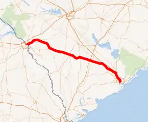
US 78 highlighted in red | ||||
| Route information | ||||
| Maintained by SCDOT | ||||
| Length | 142.207 mi[1][2][3][4][5][6] (228.860 km) | |||
| Existed | 1927–present | |||
| Major junctions | ||||
| West end | ||||
| East end | Line Street / King Street in Charleston | |||
| Location | ||||
| Counties | Aiken, Barnwell, Bamberg, Orangeburg, Dorchester, Charleston | |||
| Highway system | ||||
| ||||

Route description
US 78 enters South Carolina by crossing the Savannah River in North Augusta; sharing concurrences with US 1, US 25, US 278 and South Carolina Highway 121 (SC 121). In the immediate 2-mile (3.2 km) area, it sheds most concurrencies, sharing only with US 1 towards Aiken; it also connects with Interstate 520 (I-520), which is a partial beltway around the Augusta metropolitan area. In Aiken, it travels through the downtown area, where US 1 splits north towards Columbia. West of Williston is SC 781, which connects back with US 278; the routing allows travelers to bypass Aiken all together between Williston and Augusta.[7]
Traveling in a southeasterly direction, it goes through the cities and towns of Williston, Blackville, Denmark, Bamberg, Branchville and St. George, where connects with I-95. Continuing east, it passes through Dorchester and begins to parallel with I-26 in a southeasterly direction through Summerville. It enters Charleston County at Lincolnville, where the highway skirts just inches south of the Berkeley County line. In North Charleston, US 78 shares a concurrency with US 52, as it connects with I-526. Entering Charleston, it splits with US 52 and goes south along King Street; its eastern terminus at Line Street, a block away from US 52's eastern/southern terminus and nearby to I-26/US 17 interchange.[7]
US 78 is a predominantly two-lane rural highway connecting much of the Lowcountry. Wider sections (four-lanes or more) are found between North Augusta–Aiken, St. George, and North Charleston. Though it provides the most direct route between Augusta and Charleston (using US 278 and SC 781 to bypass Aiken), it is not a busy route because of the many cities and towns it goes through.[7]
History
Established in 1927 as an original US highway, it traveled closely as it does today; from North Augusta to Charleston, connecting the cities and towns of Aiken, Bamberg, St. George, and North Charleston.
By 1931, US 78 was rerouted north of Summerville and Lincolnville, leaving Richardson Avenue/Lincoln Avenue. Around 1939, US 78 was realigned from Meeting Street to Rivers Street, south of Durant Avenue in the Charleston area. Also in 1939, US 78 was fully paved in the state, its last unpaved section was between St. George and US 178. By 1952, US 78 was placed on new four-lane highway bypassing Clearwater, Burnettown, and Gloverville; also by same year a new bridge was constructed over the Savannah River, leaving Fifth Street Bridge. By 1967, US 78 was adjusted to bypass south of mainstreet Blackville, leaving a secondary road, but was later upgraded as a connector (signed as a business loop).[8][9]
Major intersections
| County | Location | mi[1][2][3][4][5][6] | km | Destinations | Notes | |||
|---|---|---|---|---|---|---|---|---|
| Aiken | North Augusta | 0.000– 0.005 | 0.000– 0.0080 | Western end of SC 121; continuation from Georgia over the Savannah River; southern terminus of SC 121 | ||||
| 0.188– 0.340 | 0.303– 0.547 | 5th Street Bridge / River North Drive | Interchange | |||||
| 0.640– 0.710 | 1.030– 1.143 | Eastern end of US 25 and SC 121 concurrencies; interchange | ||||||
| 0.870 | 1.400 | East Buena Vista Avenue west (SC 125 Conn. north)[10] | No access from Jefferson Davis Highway northbound to SC 125 Conn. or vice versa; southern terminus of SC 125 Conn. | |||||
| 1.560– 1.950 | 2.511– 3.138 | I-520 exit 17 | ||||||
| Clearwater | 2.150– 2.380 | 3.460– 3.830 | Eastern end of US 278 concurrency; southern terminus of SC 421; interchange | |||||
| Clearwater–Burnettown line | 4.040 | 6.502 | ||||||
| Warrenville | 10.324– 10.330 | 16.615– 16.625 | ||||||
| Aiken | 12.300 | 19.795 | Southern terminus of US 1 Truck; western terminus of US 78 Truck; to USC Aiken | |||||
| 12.470 | 20.069 | Northern terminus of SC 421 | ||||||
| 15.620 | 25.138 | |||||||
| 15.800 | 25.428 | Signed also as SC 19 | ||||||
| 15.890 | 25.572 | Eastern end of US 1 concurrency | ||||||
| | 18.250 | 29.371 | Western terminus of SC 4 | |||||
| | 18.450 | 29.692 | Western end of SC 4 Truck concurrency; southern terminus of US 1 Truck; eastern terminus of US 78 Truck; northern terminus of SC 118 | |||||
| Windsor | 28.880 | 46.478 | Eastern end of SC 4 Truck concurrency | |||||
| | 34.157 | 54.970 | Eastern terminus of SC 781 | |||||
| Barnwell | Williston | 37.297 | 60.024 | Western end of SC 39 concurrency | ||||
| 37.550 | 60.431 | Eastern end of SC 39 concurrency | ||||||
| Elko | 40.470 | 65.130 | ||||||
| Blackville | 46.930 | 75.527 | Signed western terminus of US 78 Bus. | |||||
| 47.010 | 75.655 | |||||||
| 47.090 | 75.784 | Northern terminus of SC 304 | ||||||
| 47.540 | 76.508 | Eastern terminus of US 78 Bus./US 78 Conn. | ||||||
| Bamberg | Denmark | 55.250 | 88.916 | |||||
| Bamberg | 61.960 | 99.715 | ||||||
| 62.710 | 100.922 | Northern terminus of SC 362 | ||||||
| | 71.980 | 115.841 | Northern terminus of SC 61 | |||||
| | 72.170 | 116.146 | Northern terminus of US 78 Conn. | |||||
| Orangeburg | Branchville | 76.660 | 123.372 | Western end of US 21 concurrency | ||||
| 76.860 | 123.694 | Eastern end of US 21 concurrency | ||||||
| Dorchester | St. George | 89.810– 89.830 | 144.535– 144.567 | I-95 exit 77 | ||||
| 91.830 | 147.786 | |||||||
| | 105.470 | 169.738 | Eastern terminus of US 178 | |||||
| | 108.176 | 174.092 | Western end of SC 27 concurrency | |||||
| | 108.664 | 174.878 | Eastern end of SC 27 concurrency | |||||
| | 110.114 | 177.211 | School Street west (SC 173 west) / Myers–Mayo Road east | Eastern terminus of SC 173 and School Street; western terminus of Myers–Mayo Road | ||||
| Summerville | 119.124 | 191.711 | ||||||
| 119.404 | 192.162 | |||||||
| Charleston–Dorchester county line |
No major junctions | |||||||
| Dorchester |
No major junctions | |||||||
| Charleston |
No major junctions | |||||||
| Charleston–Berkeley county line |
No major junctions | |||||||
| Charleston | North Charleston | 126.114– 126.139 | 202.961– 203.001 | I-26 exit 205 | ||||
| 127.534– 128.334 | 205.246– 206.534 | Western end of US 52 concurrency; western terminus of N.A.D. Road; interchange | ||||||
| 129.224 | 207.966 | Northern terminus of US 52 Conn.; I-26 exit 209A; no access to I-26 west | ||||||
| 133.844– 134.034 | 215.401– 215.707 | I-526 exit 18 | ||||||
| 137.044 | 220.551 | Eastern terminus of SC 642 | ||||||
| 137.194 | 220.792 | Northern terminus of SC 7 | ||||||
| 137.684 | 221.581 | Eastern end of US 52 concurrency | ||||||
| Charleston | 142.207 | 228.860 | No access from US 78 (King Street) or Line Street eastbound to westbound Line Street; eastern terminus | |||||
1.000 mi = 1.609 km; 1.000 km = 0.621 mi
| ||||||||
See also
 United States portal
 U.S. roads portal
- Special routes of U.S. Route 78
References
- "Highway Logmile Report". South Carolina Department of Transportation. Retrieved January 3, 2021.
- "Highway Logmile Report". South Carolina Department of Transportation. Retrieved January 3, 2021.
- "Highway Logmile Report". South Carolina Department of Transportation. Retrieved January 3, 2021.
- "Highway Logmile Report". South Carolina Department of Transportation. Retrieved January 3, 2021.
- "Highway Logmile Report". South Carolina Department of Transportation. Retrieved January 3, 2021.
- "Highway Logmile Report". South Carolina Department of Transportation. Retrieved January 3, 2021.
- Google (May 23, 2013). "Overview map of US 78 in South Carolina" (Map). Google Maps. Google. Retrieved May 23, 2013.
- General Highway Map, Barnwell County, South Carolina (PDF) (Map). Cartography by SCDOT. South Carolina Department of Transportation. 1967. Retrieved April 11, 2014.
- General Highway Map, Barnwell County, South Carolina (PDF) (Map). Cartography by SCDOT. South Carolina Department of Transportation. 1987. Retrieved April 11, 2014.
- Aiken & North Augusta Urban Area (PDF) (Map). South Carolina Department of Transportation. August 2019. p. Sheet 6. Retrieved September 12, 2020.
External links
 Media related to U.S. Route 78 in South Carolina at Wikimedia Commons
- End of US highway 78 on USends.com
- US 78 at Virginia Highways' South Carolina Highways Annex
| Previous state: Georgia |
South Carolina | Next state: Terminus |
