South Dakota Highway 262
South Dakota Highway 262 (SD 262) is a 17.563-mile-long (28.265 km) state highway in the U.S. state of South Dakota that runs from Interstate 90 (I-90) near Alexandria to SD 42 in Bridgewater. It is maintained by the South Dakota Department of Transportation (SDDOT), and is not part of the National Highway System.
| ||||
|---|---|---|---|---|
 | ||||
| Route information | ||||
| Defined by SDCL §31-4-225 | ||||
| Maintained by SDDOT | ||||
| Length | 17.563 mi[1] (28.265 km) | |||
| Major junctions | ||||
| West end | ||||
| East end | ||||
| Location | ||||
| Counties | Hanson, McCook | |||
| Highway system | ||||
| ||||

Route description
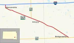
SD 262 begins at a diamond interchange with I-90 in rural Hanson County and heads south. The road almost immediately enters the city of Alexandria and takes the name of Spruce Street. In Alexandria, the route curves to the southeast and parallels a railroad. After this, SD 262 leaves the city and continues southeast. The highway crosses Pierre Creek just east of the city and passes through a series of curves which take the highway farther southeast. The road continues to parallel the railroad and intersects the southern terminus of SD 25 before traversing the community of Emery. East of Emery, SD 262 treks farther southeast through open plains and enters McCook County. The route travels for about six miles (9.7 km), then enters Bridgewater. Here, the highway reaches its eastern terminus at an intersection with SD 42.[2][3]
SD 262 is maintained by SDDOT. In 2012, the traffic on the road was measured in average annual daily traffic. SD 262 had a high of 1,935 vehicles in Alexandria and a low of 565 vehicles between the Hanson–McCook county line and Bridgewater.[1] The route is not a part of the National Highway System,[4] a system of highways important to the nation's defense, economy, and mobility.[5]
History
SD 262 follows part of the former routing of U.S. Route 16.
Major intersections
| County | Location | mi[1] | km | Destinations | Notes |
|---|---|---|---|---|---|
| Hanson | Wayne Township | 0.000 | 0.000 | I-90 Exit 344. Western terminus. | |
| Pleasant Township | 8.563 | 13.781 | Southern terminus of SD 25 | ||
| McCook | Bridgewater | 17.563 | 28.265 | Eastern terminus | |
| 1.000 mi = 1.609 km; 1.000 km = 0.621 mi | |||||
References
- "State Highway Log" (PDF). South Dakota Department of Transportation. January 2012. Retrieved 2013-03-16.
- Google (March 16, 2013). "South Dakota Highway 262" (Map). Google Maps. Google. Retrieved March 16, 2013.
- South Dakota Atlas & Gazetteer. Yarmouth, ME: DeLorme. 2009. p. 57. ISBN 0-89933-330-3.
- National Highway System: South Dakota (PDF) (Map). Federal Highway Administration. October 1, 2012. Retrieved March 16, 2013.
- Natzke, Stefan; Neathery, Mike; Adderly, Kevin (September 26, 2012). "What is the National Highway System?". National Highway System. Federal Highway Administration. Retrieved March 16, 2013.