South Shore, South Dakota
South Shore is a town in Codlington County, South Dakota, United States. The population was 227 at the 2010 census. It is part of the Watertown, South Dakota Micropolitan Statistical Area.
South Shore, South Dakota | |
|---|---|
Town | |
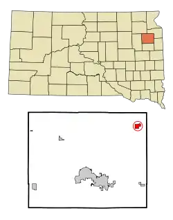 Location in Codington County and the state of South Dakota | |
| Coordinates: 45°6′18″N 96°55′41″W | |
| Country | United States |
| State | South Dakota |
| County | Codington |
| Area | |
| • Total | 1.40 sq mi (3.62 km2) |
| • Land | 1.40 sq mi (3.62 km2) |
| • Water | 0.00 sq mi (0.00 km2) |
| Elevation | 1,877 ft (572 m) |
| Population | |
| • Total | 225 |
| • Estimate (2019)[3] | 215 |
| • Density | 153.90/sq mi (59.43/km2) |
| Time zone | UTC-6 (Central (CST)) |
| • Summer (DST) | UTC-5 (CDT) |
| ZIP code | 57263 |
| Area code(s) | 605 |
| FIPS code | 46-59940[4] |
| GNIS feature ID | 1258216[5] |
Geography
South Shore is located at 45°6′18″N 96°55′41″W (45.105087, -96.927985).[6]
According to the United States Census Bureau, the town has a total area of 1.40 square miles (3.63 km2), all land.[7]
South Shore has been assigned the ZIP code 57263 and the FIPS place code 59940.
The town takes its name from its location on Punished Woman's Lake.[8]
Demographics
| Historical population | |||
|---|---|---|---|
| Census | Pop. | %± | |
| 1910 | 335 | — | |
| 1920 | 305 | −9.0% | |
| 1930 | 322 | 5.6% | |
| 1940 | 296 | −8.1% | |
| 1950 | 269 | −9.1% | |
| 1960 | 259 | −3.7% | |
| 1970 | 199 | −23.2% | |
| 1980 | 241 | 21.1% | |
| 1990 | 260 | 7.9% | |
| 2000 | 270 | 3.8% | |
| 2010 | 225 | −16.7% | |
| 2019 (est.) | 215 | [3] | −4.4% |
| U.S. Decennial Census[9] | |||
2010 census
As of the census[2] of 2010, there were 225 people, 99 households, and 56 families residing in the town. The population density was 160.7 inhabitants per square mile (62.0/km2). There were 122 housing units at an average density of 87.1 per square mile (33.6/km2). The racial makeup of the town was 95.1% White, 0.4% African American, 1.8% Native American, and 2.7% from two or more races. Hispanic or Latino of any race were 1.8% of the population.
There were 99 households, of which 29.3% had children under the age of 18 living with them, 44.4% were married couples living together, 6.1% had a female householder with no husband present, 6.1% had a male householder with no wife present, and 43.4% were non-families. 39.4% of all households were made up of individuals, and 10.1% had someone living alone who was 65 years of age or older. The average household size was 2.27 and the average family size was 3.00.
The median age in the town was 39.2 years. 28.4% of residents were under the age of 18; 5.8% were between the ages of 18 and 24; 26.2% were from 25 to 44; 24.8% were from 45 to 64; and 14.7% were 65 years of age or older. The gender makeup of the town was 51.1% male and 48.9% female.
2000 census
As of the census[4] of 2000, there were 270 people, 116 households, and 77 families residing in the town. The population density was 193.4 people per square mile (74.5/km2). There were 131 housing units at an average density of 93.9 per square mile (36.1/km2). The racial makeup of the town was 98.89% White and 1.11% Native American.
There were 116 households, out of which 31.0% had children under the age of 18 living with them, 53.4% were married couples living together, 9.5% had a female householder with no husband present, and 33.6% were non-families. 28.4% of all households were made up of individuals, and 13.8% had someone living alone who was 65 years of age or older. The average household size was 2.33 and the average family size was 2.91.
In the town, the population was spread out, with 25.6% under the age of 18, 8.1% from 18 to 24, 22.6% from 25 to 44, 25.9% from 45 to 64, and 17.8% who were 65 years of age or older. The median age was 41 years. For every 100 females, there were 94.2 males. For every 100 females age 18 and over, there were 99.0 males.
The median income for a household in the town was $28,250, and the median income for a family was $36,875. Males had a median income of $25,313 versus $19,375 for females. The per capita income for the town was $21,341. About 5.1% of families and 7.3% of the population were below the poverty line, including 10.2% of those under the age of eighteen and 9.5% of those 65 or over.
References
- "2019 U.S. Gazetteer Files". United States Census Bureau. Retrieved July 30, 2020.
- "U.S. Census website". United States Census Bureau. Retrieved 2012-06-21.
- "Population and Housing Unit Estimates". United States Census Bureau. May 24, 2020. Retrieved May 27, 2020.
- "U.S. Census website". United States Census Bureau. Retrieved 2008-01-31.
- "US Board on Geographic Names". United States Geological Survey. 2007-10-25. Retrieved 2008-01-31.
- "US Gazetteer files: 2010, 2000, and 1990". United States Census Bureau. 2011-02-12. Retrieved 2011-04-23.
- "US Gazetteer files 2010". United States Census Bureau. Archived from the original on 2012-01-24. Retrieved 2012-06-21.
- Federal Writers' Project (1940). South Dakota place-names, v.1-3. University of South Dakota. p. 61.
- "Census of Population and Housing". Census.gov. Retrieved June 4, 2015.
Municipalities and communities of Codington County, South Dakota, United States | ||
|---|---|---|
| City | 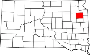 | |
| Towns | ||
| CDP | ||
| Unincorporated communities | ||
| Indian reservation | ||
| Footnotes | ‡This populated place also has portions in an adjacent county or counties | |
| ||