Southmont, Pennsylvania
Southmont is a borough in Cambria County, Pennsylvania, United States. It is part of the Johnstown, Pennsylvania Metropolitan Statistical Area. The population was 2,284 at the 2010 census.[3] It was incorporated in 1919 out of Upper Yoder Township.
Southmont, Pennsylvania | |
|---|---|
Borough | |
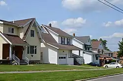 Houses on King Street | |
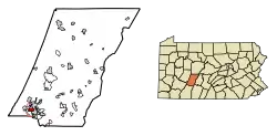 Location of Southmont in Cambria County, Pennsylvania. | |
| Coordinates: 40°18′39″N 78°56′02″W | |
| Country | United States |
| State | Pennsylvania |
| County | Cambria |
| Settled | 1850 |
| Incorporated | 1919 |
| Government | |
| • Type | Borough council |
| Area | |
| • Total | 1.05 sq mi (2.72 km2) |
| • Land | 1.05 sq mi (2.72 km2) |
| • Water | 0.00 sq mi (0.00 km2) |
| Elevation | 1,572 ft (479 m) |
| Population (2010) | |
| • Total | 2,284 |
| • Estimate (2019)[2] | 2,076 |
| • Density | 1,977.14/sq mi (763.60/km2) |
| Time zone | UTC-5 (Eastern (EST)) |
| • Summer (DST) | UTC-4 (EDT) |
| Area code(s) | 814 |
| FIPS code | 42-72344 |
| Website | www |
Geography
Southmont is located in southwestern Cambria County at 40°18′39″N 78°56′2″W (40.310874, -78.934005).[4] It is bordered to the east by the city of Johnstown, to the north by the borough of Westmont, and to the southwest by the unincorporated community of Elim in Upper Yoder Township. Southmont is located on heights rising nearly 600 feet (180 m) above the valley of the Stonycreek River which flows through Johnstown.
According to the United States Census Bureau, the borough has a total area of 1.0 square mile (2.7 km2), all of it land.[3]
Demographics
| Historical population | |||
|---|---|---|---|
| Census | Pop. | %± | |
| 1920 | 281 | — | |
| 1930 | 1,925 | 585.1% | |
| 1940 | 2,146 | 11.5% | |
| 1950 | 2,278 | 6.2% | |
| 1960 | 2,857 | 25.4% | |
| 1970 | 2,653 | −7.1% | |
| 1980 | 2,683 | 1.1% | |
| 1990 | 2,415 | −10.0% | |
| 2000 | 2,262 | −6.3% | |
| 2010 | 2,284 | 1.0% | |
| 2019 (est.) | 2,076 | [2] | −9.1% |
| Sources:[5][6][7] | |||
As of the census[6] of 2000, there were 2,262 people, 965 households, and 660 families residing in the borough. The population density was 2,151.1 people per square mile (831.8/km2). There were 1,021 housing units at an average density of 970.9 per square mile (375.4/km2). The racial makeup of the borough was 98.28% White, 0.22% African American, 0.04% Native American, 0.44% Asian, 0.13% from other races, and 0.88% from two or more races. Hispanic or Latino of any race were 0.49% of the population.
There were 965 households, out of which 27.2% had children under the age of 18 living with them, 58.1% were married couples living together, 8.7% had a female householder with no husband present, and 31.6% were non-families. 29.5% of all households were made up of individuals, and 13.6% had someone living alone who was 65 years of age or older. The average household size was 2.32 and the average family size was 2.87.
In the borough the population was spread out, with 22.0% under the age of 18, 4.2% from 18 to 24, 25.5% from 25 to 44, 27.4% from 45 to 64, and 20.9% who were 65 years of age or older. The median age was 44 years. For every 100 females there were 89.3 males. For every 100 females age 18 and over, there were 87.1 males.
The median income for a household in the borough was $38,125, and the median income for a family was $49,297. Males had a median income of $36,553 versus $25,398 for females. The per capita income for the borough was $25,750. About 4.5% of families and 5.2% of the population were below the poverty line, including 7.7% of those under age 18 and 2.7% of those age 65 or over.
References
- "2019 U.S. Gazetteer Files". United States Census Bureau. Retrieved July 28, 2020.
- "Population and Housing Unit Estimates". United States Census Bureau. May 24, 2020. Retrieved May 27, 2020.
- "Geographic Identifiers: 2010 Demographic Profile Data (G001): Southmont borough, Pennsylvania". U.S. Census Bureau, American Factfinder. Archived from the original on March 19, 2015. Retrieved March 19, 2015.
- "US Gazetteer files: 2010, 2000, and 1990". United States Census Bureau. 2011-02-12. Retrieved 2011-04-23.
- "Census of Population and Housing". U.S. Census Bureau. Retrieved 11 December 2013.
- "U.S. Census website". United States Census Bureau. Retrieved 2008-01-31.
- "Incorporated Places and Minor Civil Divisions Datasets: Subcounty Resident Population Estimates: April 1, 2010 to July 1, 2012". Population Estimates. U.S. Census Bureau. Archived from the original on 17 June 2013. Retrieved 11 December 2013.
External links
Municipalities and communities of Cambria County, Pennsylvania, United States | ||
|---|---|---|
| City |  | |
| Boroughs |
| |
| Townships | ||
| CDPs |
| |
| Unincorporated communities | ||
| Footnotes | ‡This populated place also has portions in an adjacent county or counties | |
| ||
| Authority control |
|---|