Tunnelhill, Pennsylvania
Tunnelhill is a borough that is located in both Cambria and Blair counties in Pennsylvania in the United States.[3][4] The population was 363 at the 2010 census. Of this, 245 were in Cambria County, and 118 were in Blair County. It is part of the Altoona, PA Metropolitan Statistical Area. Tunnelhill is named after the many railroad tunnels of the Pennsylvania Railroad near here known as the Gallitzin Tunnels.
Tunnelhill, Pennsylvania | |
|---|---|
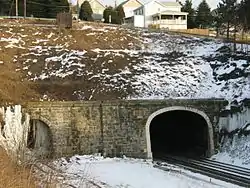 Gallitzin Tunnels | |
 Location of Tunnelhill in Blair County, Pennsylvania. | |
 Tunnelhill Location of Tunnelhill in Blair County, Pennsylvania. | |
| Coordinates: 40°28′39″N 78°32′29″W | |
| Country | United States |
| State | Pennsylvania |
| Counties | Blair and Cambria |
| Incorporated | 1876 |
| Government | |
| • Type | Borough Council |
| Area | |
| • Total | 0.49 sq mi (1.28 km2) |
| • Land | 0.49 sq mi (1.28 km2) |
| • Water | 0.00 sq mi (0.00 km2) |
| Elevation | 2,300 ft (700 m) |
| Population (2010) | |
| • Total | 363 |
| • Estimate (2019)[2] | 331 |
| • Density | 671.40/sq mi (259.07/km2) |
| Time zone | UTC-5 (Eastern (EST)) |
| • Summer (DST) | UTC-4 (EDT) |
| Zip code | 16641 |
| Area code(s) | 814 |
| FIPS code | 42-77808 |
Geography
Tunnelhill is located at 40°28′39″N 78°32′29″W (40.477501, -78.541363).[5]
According to the United States Census Bureau, the borough has a total area of 0.5 square miles (1.2 km2). None of the area is covered with water.
Tunnelhill has the third-highest elevation of towns in Pennsylvania, at 2300 feet.[6]
Demographics
| Historical population | |||
|---|---|---|---|
| Census | Pop. | %± | |
| 1880 | 224 | — | |
| 1890 | 730 | 225.9% | |
| 1900 | 674 | −7.7% | |
| 1910 | 661 | −1.9% | |
| 1920 | 619 | −6.4% | |
| 1930 | 690 | 11.5% | |
| 1940 | 625 | −9.4% | |
| 1950 | 535 | −14.4% | |
| 1960 | 463 | −13.5% | |
| 1970 | 508 | 9.7% | |
| 1980 | 513 | 1.0% | |
| 1990 | 365 | −28.8% | |
| 2000 | 409 | 12.1% | |
| 2010 | 363 | −11.2% | |
| 2019 (est.) | 331 | [2] | −8.8% |
| Sources:[7][8][9] | |||
As of the census[8] of 2000, there were 409 people, 178 households, and 100 families living in the borough. The population density was 844.4 people per square mile (329.0/km2). There were 188 housing units at an average density of 388.1 per square mile (151.2/km2). The racial makeup of the borough was 98.78% White, 0.24% Native American, 0.24% Asian, 0.24% Pacific Islander, and 0.49% from two or more races.
There were 178 households, out of which 23.0% had children under the age of 18 living with them, 42.1% were married couples living together, 8.4% had a female householder with no husband present, and 43.8% were non-families. 38.8% of all households were made up of individuals, and 21.9% had someone living alone who was 65 years of age or older. The average household size was 2.27 and the average family size was 3.09.
In the borough the population was spread out, with 19.8% under the age of 18, 8.1% from 18 to 24, 23.7% from 25 to 44, 24.0% from 45 to 64, and 24.4% who were 65 years of age or older. The median age was 44 years. For every 100 females there were 88.5 males. For every 100 females age 18 and over, there were 87.4 males.
The median income for a household in the borough was $22,604, and the median income for a family was $34,500. Males had a median income of $23,500 versus $16,250 for females. The per capita income for the borough was $13,042. About 10.4% of families and 16.9% of the population were below the poverty line, including 22.2% of those under age 18 and 10.3% of those age 65 or over.
References
- "2019 U.S. Gazetteer Files". United States Census Bureau. Retrieved July 28, 2020.
- "Population and Housing Unit Estimates". United States Census Bureau. May 24, 2020. Retrieved May 27, 2020.
- Geographic Names Information System, United States Geological Survey (August 30, 1990). "Geographic Names Information System Feature Detail Report: Borough of Tunnelhill". Retrieved 2007-05-19.
- "TUNNELHILL COMMUNITY PROFILE". ePodunk Inc. Retrieved 2007-05-18.
- "US Gazetteer files: 2010, 2000, and 1990". United States Census Bureau. 2011-02-12. Retrieved 2011-04-23.
- Highest Elevation of Towns in Pennsylvania
- "Census of Population and Housing". U.S. Census Bureau. Retrieved 11 December 2013.
- "U.S. Census website". United States Census Bureau. Retrieved 2008-01-31.
- "Incorporated Places and Minor Civil Divisions Datasets: Subcounty Resident Population Estimates: April 1, 2010 to July 1, 2012". Population Estimates. U.S. Census Bureau. Archived from the original on 11 June 2013. Retrieved 11 December 2013.
Municipalities and communities of Cambria County, Pennsylvania, United States | ||
|---|---|---|
| City | 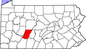 | |
| Boroughs |
| |
| Townships | ||
| CDPs |
| |
| Unincorporated communities | ||
| Footnotes | ‡This populated place also has portions in an adjacent county or counties | |
| ||
Municipalities and communities of Blair County, Pennsylvania, United States | ||
|---|---|---|
| City | 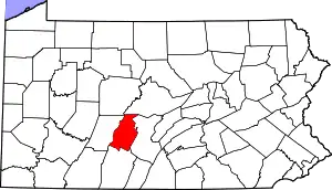 | |
| Boroughs | ||
| Townships | ||
| CDPs | ||
| Unincorporated communities | ||
| Footnotes | ‡This populated place also has portions in an adjacent county or counties | |
| ||