St Mary Bourne
St Mary Bourne is a village and civil parish in the Basingstoke and Deane district of Hampshire, England. It lies on the valley of the Bourne Rivulet, a tributary of the River Test, 5 miles (8.0 km) northeast of Andover.
| St Mary Bourne | |
|---|---|
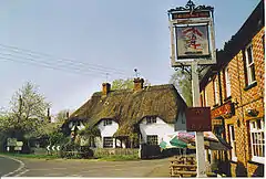 Thatched Cottage and The George Inn | |
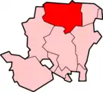
 St Mary Bourne Location within Hampshire | |
| Population | 1,298 (parish 2011 Census including Little Bourne, Little Down, Middle Wyke, Stoke and Wadwick)[1] |
| OS grid reference | SU422503 |
| Civil parish |
|
| District | |
| Shire county | |
| Region | |
| Country | England |
| Sovereign state | United Kingdom |
| Post town | ANDOVER |
| Postcode district | SP11 |
| Dialling code | 01264 |
| Police | Hampshire |
| Fire | Hampshire |
| Ambulance | South Central |
| UK Parliament | |
Governance
The village of St. Mary Bourne is part of the civil parish of St. Mary Bourne,[2] and is part of the Burghclere, Highclere and St. Mary Bourne ward of Basingstoke and Deane borough council.[3] The borough council is a Non-metropolitan district of Hampshire County Council. It includes Binley, and the hamlets of Swampton and Stoke further up the Bourne rivulet valley.
Geography
The village is in a rural area of downland, with a mixture of farms and woodlands nearby. The Bourne Rivulet flows through the centre of the village and has been known to flood.
Landmarks

It has thatched houses and in the south part of the village is the flint and stone church of St Peter. The church is notable for its 12th-century Tournai font.
Further reading
- Reverend Stephen Pakenham, with additional material by Canon Martin Coppen The Story of St Peter's Church, St Mary Bourne: A Short Guide for Visitors, 2009 (available from the church)
- A Full Church Guide (available from the church)
References
- "Civil Parish population 2011". Neighbourhood Statistics. Office for National Statistics. Retrieved 22 December 2016.
- "Hampshire County Council's legal record of public rights of way in Hampshire" (PDF). 2008. Retrieved 26 October 2010.
- "Basingstoke and Deane Wards info". 2010. Archived from the original on 24 October 2010. Retrieved 26 October 2010.
External links
| Wikimedia Commons has media related to St Mary Bourne. |
- St Mary Bourne Community Hub
- St Mary Bourne Parish Council
- Stained Glass Windows at St. Peter, St Mary Bourne, Hampshire
- 'Parishes: St. Mary Bourne', A History of the County of Hampshire: Volume 4 (1911), pp. 295-299
- St Peter’s, St Mary Bourne