Standburn
Standburn is a small village which lies within the Falkirk council area in central Scotland. It is located 1.3 miles (2.1 km) south-west of Maddiston, 1.7 miles (2.7 km) north-east of Avonbridge and 4.0 miles (6.4 km) south east of Falkirk. The entire village is located along a section of the B825 road between Avonbridge and Loan.
| Standburn | |
|---|---|
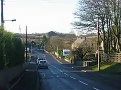 The village of Standburn | |
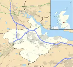 Standburn Location within the Falkirk council area | |
| Population | 149 [1] (2001 census) |
| OS grid reference | NS925745 |
| Civil parish |
|
| Council area | |
| Lieutenancy area | |
| Country | Scotland |
| Sovereign state | United Kingdom |
| Post town | FALKIRK |
| Postcode district | FK1 |
| Dialling code | 01324 |
| UK Parliament | |
| Scottish Parliament | |
| Website | falkirk.gov.uk |
The United Kingdom Census 2001 reported the population as 149 residents, a figure almost unchanged from the census of 1991
Drumbowie Environment Action Group is a charitable organisation which owns Drumbowie Park to the north of Standburn, this community woodland is open to the public.
Standburn was a mining community with several active pits until the 1950s. The pits were individually numbered and all prefixed by Gateside. The bings from the mining days can still be seen although the land has now been planted with trees and named Gateside Woodland.
References
- No 3 - 2001 Census Population of settlements and wards Archived 2011-06-03 at the Wayback Machine www.falkirk.gov.uk. Retrieved 2011-05-02
