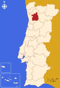
Tâmega e Sousa
The Comunidade Intermunicipal do Tâmega e Sousa (Portuguese pronunciation: [ˈtɐmɨgɐ i ˈso(w)zɐ]) is an administrative division in northern Portugal. It was created in 2009.[1] Since January 2015, Tâmega e Sousa is also a NUTS3 subregion of Norte Region, that covers the same area as the intermunicipal community.[2] The seat of the intermunicipal community is Penafiel. Tâmega e Sousa comprises parts of the former districts of Aveiro, Braga, Porto and Viseu. The population in 2011 was 432,915,[3] in an area of 1,831.52 km².[4]
Tâmega e Sousa | |
|---|---|
 | |
| Coordinates: 41.21°N 8.28°W | |
| Country | |
| Region | Norte |
| Established | 2009 |
| Seat | Penafiel |
| Municipalities | 11 |
| Area | |
| • Total | 1,831.52 km2 (707.15 sq mi) |
| Population (2011) | |
| • Total | 432,915 |
| • Density | 240/km2 (610/sq mi) |
| Time zone | UTC±00:00 (WET) |
| • Summer (DST) | UTC+01:00 (WEST) |
| Website | www |

Map showing the location of the Tâmega e Sousa intermunicipal community
Municipalities
The intermunicipal community of Tâmega e Sousa consists of 11 municipalities:[5]
| Municipality | Population (2011)[3] | Area (km²)[4] |
|---|---|---|
| Amarante | 56,264 | 301.33 |
| Baião | 20,522 | 174.53 |
| Castelo de Paiva | 16,733 | 115.01 |
| Celorico de Basto | 20,098 | 181.07 |
| Cinfães | 20,427 | 239.29 |
| Felgueiras | 58,065 | 115.74 |
| Lousada | 47,387 | 96.08 |
| Marco de Canaveses | 53,450 | 201.89 |
| Paços de Ferreira | 56,340 | 70.99 |
| Penafiel | 72,265 | 212.24 |
| Resende | 11,364 | 123.35 |
| Total | 432,915 | 1,831.52 |
References
- CIM Tâmega e Sousa
- Adequação dos indicadores à nova organização territorial NUTS III / Entidades Intermunicipais, Instituto Nacional de Estatística, 18 March 2015
- Instituto Nacional de Estatística
- Áreas das freguesias, concelhos, distritos e país
- "Law nr. 75/2013" (pdf). Diário da República (in Portuguese). Assembly of the Republic (Portugal). Retrieved 18 August 2014.
This article is issued from Wikipedia. The text is licensed under Creative Commons - Attribution - Sharealike. Additional terms may apply for the media files.