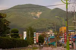
Taebaek
Taebaek (Korean pronunciation: [tʰɛ̝.bɛ̝k̚]) is a city in Gangwon province, South Korea. Its name is shared with that of the Taebaek Mountains. Situated at an altitude of 650 to 700 m (2,130 to 2,300 ft), Taebaek is the highest city in South Korea.
Taebaek
태백시 | |
|---|---|
| Korean transcription(s) | |
| • Hangul | 태백시 |
| • Hanja | 太白市 |
| • Revised Romanization | Taebaek-si |
| • McCune-Reischauer | T'aebaek-si |
 | |
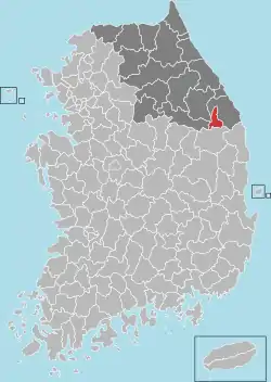 Location in South Korea | |
| Coordinates: 37°10′N 128°59′E | |
| Country | |
| Region | Gwandong |
| Administrative divisions | 8 dong |
| Area | |
| • Total | 303.53 km2 (117.19 sq mi) |
| Population (2015) | |
| • Total | 46,715 |
| • Density | 185/km2 (480/sq mi) |
| • Dialect | Gangwon |
| Climate | Dwb |
Attractions
Manggyeongsa Temple in Hyeol-dong, at an altitude of 1,460 meters on the Taebaek Mountains, is a temple built to enshrine the statue of the Bodhisattva of wisdom. It was built by Jajang, a Silla Dynasty monk. The "Dragon Spring" at the entrance of the temple is known as the highest spring in Korea.[1]
Climate
| Climate data for Taebaek (1981–2010, extremes 1985–present) | |||||||||||||
|---|---|---|---|---|---|---|---|---|---|---|---|---|---|
| Month | Jan | Feb | Mar | Apr | May | Jun | Jul | Aug | Sep | Oct | Nov | Dec | Year |
| Record high °C (°F) | 12.1 (53.8) |
20.1 (68.2) |
21.6 (70.9) |
29.7 (85.5) |
32.6 (90.7) |
35.0 (95.0) |
34.2 (93.6) |
35.6 (96.1) |
31.8 (89.2) |
26.4 (79.5) |
22.6 (72.7) |
15.2 (59.4) |
35.6 (96.1) |
| Average high °C (°F) | 0.5 (32.9) |
2.8 (37.0) |
7.2 (45.0) |
15.0 (59.0) |
20.1 (68.2) |
23.4 (74.1) |
25.3 (77.5) |
25.5 (77.9) |
21.2 (70.2) |
16.6 (61.9) |
9.7 (49.5) |
3.4 (38.1) |
14.2 (57.6) |
| Daily mean °C (°F) | −4.8 (23.4) |
−2.8 (27.0) |
1.9 (35.4) |
8.9 (48.0) |
14.0 (57.2) |
17.8 (64.0) |
20.9 (69.6) |
21.0 (69.8) |
16.0 (60.8) |
10.3 (50.5) |
3.9 (39.0) |
−2.0 (28.4) |
8.7 (47.7) |
| Average low °C (°F) | −9.7 (14.5) |
−8.0 (17.6) |
−3.2 (26.2) |
2.8 (37.0) |
8.0 (46.4) |
12.5 (54.5) |
17.2 (63.0) |
17.3 (63.1) |
11.4 (52.5) |
4.7 (40.5) |
−1.2 (29.8) |
−6.8 (19.8) |
3.8 (38.8) |
| Record low °C (°F) | −21.7 (−7.1) |
−20.3 (−4.5) |
−16.8 (1.8) |
−8.2 (17.2) |
−2.1 (28.2) |
0.5 (32.9) |
5.6 (42.1) |
8.3 (46.9) |
1.0 (33.8) |
−7.1 (19.2) |
−15.2 (4.6) |
−18.5 (−1.3) |
−21.7 (−7.1) |
| Average precipitation mm (inches) | 32.6 (1.28) |
35.8 (1.41) |
60.7 (2.39) |
77.4 (3.05) |
90.4 (3.56) |
142.2 (5.60) |
287.3 (11.31) |
279.6 (11.01) |
203.9 (8.03) |
51.8 (2.04) |
43.4 (1.71) |
19.2 (0.76) |
1,324.3 (52.14) |
| Average precipitation days (≥ 0.1 mm) | 8.3 | 7.7 | 10.5 | 8.6 | 9.4 | 11.2 | 16.5 | 15.6 | 11.5 | 6.8 | 7.6 | 6.4 | 120.1 |
| Average snowy days | 10.7 | 9.7 | 9.9 | 2.1 | 0.0 | 0.0 | 0.0 | 0.0 | 0.0 | 0.5 | 3.3 | 7.6 | 44.0 |
| Average relative humidity (%) | 61.3 | 60.6 | 61.8 | 55.3 | 61.3 | 71.8 | 78.6 | 79.8 | 78.8 | 70.3 | 64.1 | 60.5 | 67.0 |
| Mean monthly sunshine hours | 173.4 | 174.5 | 194.8 | 219.8 | 229.2 | 193.6 | 141.0 | 144.6 | 149.8 | 188.1 | 166.7 | 169.5 | 2,144.6 |
| Percent possible sunshine | 56.3 | 57.1 | 52.6 | 55.7 | 52.2 | 44.0 | 31.5 | 34.4 | 40.2 | 53.9 | 54.4 | 56.6 | 48.2 |
| Source: Korea Meteorological Administration[2][3][4] (percent sunshine and snowy days)[5] | |||||||||||||
Sister cities
References
- Cin Woo Lee "Simply stunning: 33 incredible Korean temples" Archived 2012-04-17 at the Wayback Machine CNN Go. 10 February 2012. Retrieved 2012-04-12
- 평년값자료(1981–2010) 태백(216) (in Korean). Korea Meteorological Administration. Retrieved 2011-05-01.
- 기후자료 극값(최대값) 전체년도 일최고기온 (℃) 최고순위, 태백(216) (in Korean). Korea Meteorological Administration. Retrieved 10 February 2017.
- 기후자료 극값(최대값) 전체년도 일최저기온 (℃) 최고순위, 태백(216) (in Korean). Korea Meteorological Administration. Retrieved 10 February 2017.
- "Climatological Normals of Korea" (PDF). Korea Meteorological Administration. 2011. p. 499 and 649. Archived from the original (PDF) on 7 December 2016. Retrieved 10 February 2017.
External links
This article is issued from Wikipedia. The text is licensed under Creative Commons - Attribution - Sharealike. Additional terms may apply for the media files.
