Jecheon
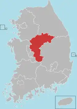
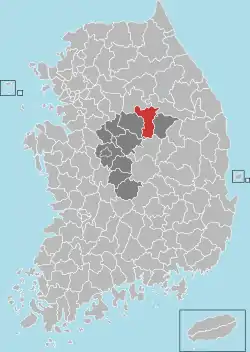
Jecheon (Korean pronunciation: [tɕe.tɕʰʌn]) is a city in North Chungcheong Province, South Korea. The city is a major railway junction or a transportation mecca, served by the Jungang, Chungbuk and Taebaek Lines. Jecheon has scenic surroundings and several tourist spots like the Uirimji Reservoir, Cheongpung Lake and Cheongpung Cultural Properties complex. It is also the home of Semyung University.
Jecheon
제천시 | |
|---|---|
| Korean transcription(s) | |
| • Hangul | 제천시 |
| • Hanja | 堤川市 |
| • Revised Romanization | Jecheon-si |
| • McCune-Reischauer | Chech'ŏn-si |
 | |
 Emblem of Jecheon | |
 Location in South Korea | |
| Country | |
| Region | Hoseo |
| Administrative divisions | 1 eup, 7 myeon, 9 dong |
| Area | |
| • Total | 882.47 km2 (340.72 sq mi) |
| Population (2011.01.04) | |
| • Total | 137,147 |
| • Density | 157.3/km2 (407/sq mi) |
| • Dialect | Chungcheong |
| Area code(s) | (+82) 43-6xx |
The city's name derives from the Korean words je (堤, which means "dam") and cheon (川, which means "river").
Location
Jecheon City is located in the northern part of North Chungcheong Province bordering Mungyeong City to the south, while Wonju City and Yeongwol-gun, which are located in Gangwon Province, are to the north. It is well known for its mountains and lake environments.[1] Jecheon is well known as the "healing city". A wide variety of traditional medical and herbal products and therapies are available, attracting people all over Korea to visit the city.
Climate
| Climate data for Jecheon (1981–2010, extremes 1971–present) | |||||||||||||
|---|---|---|---|---|---|---|---|---|---|---|---|---|---|
| Month | Jan | Feb | Mar | Apr | May | Jun | Jul | Aug | Sep | Oct | Nov | Dec | Year |
| Record high °C (°F) | 13.6 (56.5) |
19.1 (66.4) |
23.2 (73.8) |
32.2 (90.0) |
33.7 (92.7) |
34.8 (94.6) |
36.7 (98.1) |
36.9 (98.4) |
33.1 (91.6) |
28.3 (82.9) |
24.0 (75.2) |
16.0 (60.8) |
36.9 (98.4) |
| Average high °C (°F) | 1.3 (34.3) |
4.4 (39.9) |
10.3 (50.5) |
18.2 (64.8) |
23.1 (73.6) |
26.8 (80.2) |
28.4 (83.1) |
29.2 (84.6) |
25.0 (77.0) |
19.4 (66.9) |
11.1 (52.0) |
4.0 (39.2) |
16.8 (62.2) |
| Daily mean °C (°F) | −5.2 (22.6) |
−2.3 (27.9) |
3.5 (38.3) |
10.5 (50.9) |
16.0 (60.8) |
20.6 (69.1) |
23.4 (74.1) |
23.8 (74.8) |
18.4 (65.1) |
11.4 (52.5) |
4.1 (39.4) |
−2.4 (27.7) |
10.2 (50.4) |
| Average low °C (°F) | −11.2 (11.8) |
−8.4 (16.9) |
−2.8 (27.0) |
2.9 (37.2) |
9.2 (48.6) |
15.0 (59.0) |
19.5 (67.1) |
19.6 (67.3) |
13.3 (55.9) |
5.0 (41.0) |
−1.7 (28.9) |
−8.0 (17.6) |
4.4 (39.9) |
| Record low °C (°F) | −27.4 (−17.3) |
−25.9 (−14.6) |
−17.7 (0.1) |
−8.0 (17.6) |
−0.5 (31.1) |
4.8 (40.6) |
9.7 (49.5) |
9.9 (49.8) |
0.6 (33.1) |
−7.2 (19.0) |
−14.9 (5.2) |
−24.8 (−12.6) |
−27.4 (−17.3) |
| Average precipitation mm (inches) | 24.7 (0.97) |
29.4 (1.16) |
56.0 (2.20) |
76.1 (3.00) |
102.1 (4.02) |
154.2 (6.07) |
373.5 (14.70) |
293.7 (11.56) |
161.1 (6.34) |
51.5 (2.03) |
42.4 (1.67) |
23.0 (0.91) |
1,387.8 (54.64) |
| Average precipitation days (≥ 0.1 mm) | 7.2 | 6.9 | 8.9 | 7.8 | 8.4 | 9.3 | 15.6 | 13.9 | 8.8 | 5.4 | 7.4 | 7.4 | 107 |
| Average snowy days | 7.6 | 6.5 | 3.8 | 0.5 | 0.0 | 0.0 | 0.0 | 0.0 | 0.0 | 0.2 | 1.9 | 5.8 | 26.2 |
| Average relative humidity (%) | 69.4 | 66.4 | 63.8 | 58.1 | 64.0 | 69.6 | 78.5 | 77.1 | 75.3 | 72.8 | 70.9 | 71.1 | 69.8 |
| Mean monthly sunshine hours | 165.1 | 163.4 | 193.0 | 216.1 | 231.3 | 211.7 | 160.6 | 181.8 | 176.9 | 194.5 | 153.8 | 154.4 | 2,204.6 |
| Percent possible sunshine | 53.6 | 53.5 | 52.1 | 54.8 | 52.7 | 48.1 | 35.9 | 43.2 | 47.4 | 55.8 | 50.2 | 51.6 | 49.5 |
| Source: Korea Meteorological Administration[2][3][4] (percent sunshine and snowy days)[5] | |||||||||||||
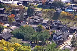
Tourism
Ten views in the city:
- Uirimji
- Bakdaljae
- Woraksan Mountain
- Cheongpoong cultural town, Hoban
- Geumsusan
- Yonghagugok
- Songgyegyegok
- Oksunbong
- Taksajeong
- Baeronseongji
Twin towns – sister cities
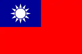 Hualien City, Taiwan
 Pasay, Philippines
 Qichun County, China
 Spokane, United States
- Zhangshu, China
Notable people from Jecheon
- Kim So-hui (Hangul: 김소희), South Korean Taekwondo practitioner
- Park Sang-ha (Hangul: 박상하), South Korean volleyball player
- Jung Woong-in (Hangul: 정웅인), South Korean actor
- Lee Sang-kyu (Hangul: 이상규), South Korean activist, labourer and politician
- Lee Byungryul (Hangul: 이병률), South Korean poet, television writer, and prose writer
- Choi Geum-jin (Hangul: 최금진), South Korean poet
- Uhm Jung-hwa (Hangul: 엄정화), South Korean singer, actress and dancer
- Hwiyoung (Real Name: Kim Young-kyun, Hangul: 김영균), singer, dancer, actor and K-pop idol, member of K-pop boygroup SF9
See also
References
- Official page
- 평년값자료(1981–2010) 제천(221) (in Korean). Korea Meteorological Administration. Retrieved 2011-05-01.
- 기후자료 극값(최대값) 전체년도 일최고기온 (℃) 최고순위, 제천(221) (in Korean). Korea Meteorological Administration. Retrieved 20 February 2017.
- 기후자료 극값(최대값) 전체년도 일최저기온 (℃) 최고순위, 제천(221) (in Korean). Korea Meteorological Administration. Retrieved 20 February 2017.
- "Climatological Normals of Korea" (PDF). Korea Meteorological Administration. 2011. p. 499 and 649. Archived from the original (PDF) on 7 December 2016. Retrieved 20 February 2017.
- "Sister/Friend city". jecheon.go.kr. Jecheon. Retrieved 2020-04-14.