Tai Shui Hang station
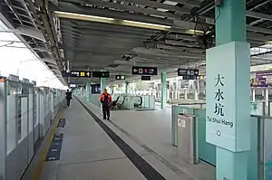
Tai Shui Hang (Chinese: 大水坑; Cantonese Yale: Daaihséuihāang) is an MTR station on the Tuen Ma line in Hong Kong. It serves residential estates including Kam Tai Court, Mountain Shore, Chevalier Garden and Sausalito, Tai Shui Hang Village and Sha Tin Fishermen's New Village. It also serves five kindergartens, primary and secondary schools. The pattern featured on the platform pillar and glass barrier is a shot of nature representing the Ma On Shan Country Park. For a period before the line opened, the station was known as "Fu On", since it is located opposite Chevalier Garden (transliterated from Chinese "Fu On Garden").
| MTR rapid transit station | |||||||||||||||||||||||||||||||||||||||||||||||||||||||||||||||
 Platform 2 | |||||||||||||||||||||||||||||||||||||||||||||||||||||||||||||||
| Chinese name | |||||||||||||||||||||||||||||||||||||||||||||||||||||||||||||||
| Chinese | 大水坑 | ||||||||||||||||||||||||||||||||||||||||||||||||||||||||||||||
| Cantonese Yale | Daaihséuihāang | ||||||||||||||||||||||||||||||||||||||||||||||||||||||||||||||
| Literal meaning | Big water pit | ||||||||||||||||||||||||||||||||||||||||||||||||||||||||||||||
| |||||||||||||||||||||||||||||||||||||||||||||||||||||||||||||||
| General information | |||||||||||||||||||||||||||||||||||||||||||||||||||||||||||||||
| Location | Near Kam Tai Court, Ma On Shan Road, Tai Shui Hang Sha Tin District, Hong Kong | ||||||||||||||||||||||||||||||||||||||||||||||||||||||||||||||
| Coordinates | 22°24′32″N 114°13′23″E | ||||||||||||||||||||||||||||||||||||||||||||||||||||||||||||||
| Owned by | KCR Corporation | ||||||||||||||||||||||||||||||||||||||||||||||||||||||||||||||
| Operated by | MTR Corporation | ||||||||||||||||||||||||||||||||||||||||||||||||||||||||||||||
| Line(s) | |||||||||||||||||||||||||||||||||||||||||||||||||||||||||||||||
| Platforms | 2 (1 island platform) | ||||||||||||||||||||||||||||||||||||||||||||||||||||||||||||||
| Tracks | 2 | ||||||||||||||||||||||||||||||||||||||||||||||||||||||||||||||
| Connections | |||||||||||||||||||||||||||||||||||||||||||||||||||||||||||||||
| Construction | |||||||||||||||||||||||||||||||||||||||||||||||||||||||||||||||
| Structure type | Elevated | ||||||||||||||||||||||||||||||||||||||||||||||||||||||||||||||
| Disabled access | Yes | ||||||||||||||||||||||||||||||||||||||||||||||||||||||||||||||
| Other information | |||||||||||||||||||||||||||||||||||||||||||||||||||||||||||||||
| Station code | TSH | ||||||||||||||||||||||||||||||||||||||||||||||||||||||||||||||
| History | |||||||||||||||||||||||||||||||||||||||||||||||||||||||||||||||
| Opened |
| ||||||||||||||||||||||||||||||||||||||||||||||||||||||||||||||
| Previous names | Fu On | ||||||||||||||||||||||||||||||||||||||||||||||||||||||||||||||
| Services | |||||||||||||||||||||||||||||||||||||||||||||||||||||||||||||||
| |||||||||||||||||||||||||||||||||||||||||||||||||||||||||||||||
| |||||||||||||||||||||||||||||||||||||||||||||||||||||||||||||||
| Location | |||||||||||||||||||||||||||||||||||||||||||||||||||||||||||||||
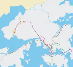
 Tai Shui Hang Location within the MTR system | |||||||||||||||||||||||||||||||||||||||||||||||||||||||||||||||
History
On 21 December 2004, Tai Shui Hang station opened to the public with the other KCR Ma On Shan Rail stations.
Station layout
| P | Platform 1 | ← Tuen Ma line towards Kai Tak (Shek Mun) |
| Island platform, doors will open on the left | ||
| Platform 2 | Tuen Ma line towards Wu Kai Sha (Heng On) → | |
| C | Concourse | Customer services, toilets |
| MTRShops, vending machines | ||
| S | Subway | Kam Tai Court and Chevalier Garden exits |
Platforms 1 and 2 share the same island platform.[1]
References
- "Tai Shui Hang Station layout" (PDF). MTR Corporation. Retrieved 30 October 2016.
- "Tai Shui Hang Station street map" (PDF). MTR Corporation. Retrieved 30 October 2016.
| Wikimedia Commons has media related to Tai Shui Hang Station. |