Taiki, Mie
Taiki (大紀町, Taiki-chō) is a town located in Watarai District, Mie Prefecture, Japan. As of September 2012, the town had an estimated population of 8,212 and a population density of 35.2 persons per km2. The total area was 233.54 km2.
Taiki
大紀町 | |
|---|---|
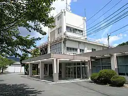 Taiki town hall | |
 Flag  Emblem | |
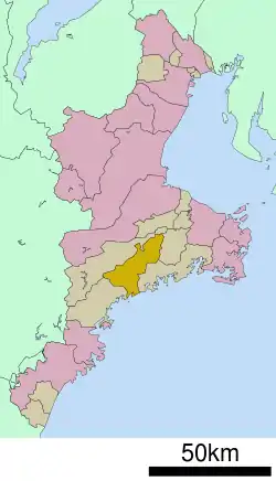 Location of Taiki in Mie Prefecture | |
 Taiki | |
| Coordinates: 34°21′N 136°25′E | |
| Country | Japan |
| Region | Kansai |
| Prefecture | Mie |
| District | Watarai |
| Area | |
| • Total | 233.54 km2 (90.17 sq mi) |
| Population (September 2012) | |
| • Total | 9,543 |
| • Density | 40.9/km2 (106/sq mi) |
| Time zone | UTC+9 (Japan Standard Time) |
| - Tree | Maki |
| - Flower | Cherry blossom |
| Phone number | 0598-86-2212 |
| Address | 1610-1 Takihara, Taiki-chō, Watarai-gun, Mie-ken 519-2703 |
| Website | www |
Geography
Taiki is located in eastern Kii Peninsula, in south-central Mie Prefecture. The town is bordered by Ise Bay to the east.
History
Tamaki was the site of a Sengoku period Japanese castle, Tamaru Castle, initially built by the Kitabatake clan, which dominated the surrounding area, including access to the Ise Grand Shrines. The castle was destroyed in the early Meiji period.
Taiki was formed on February 14, 2005, from the merger of the towns of Kisei and Ōmiya and the village of Ōuchiyama.
Economy
The town serves as a commercial center for the surrounding region. Commercial fishing and the dairy industry play important roles in the local economy.
Transportation
Railway
External links
![]() Media related to Taiki, Mie at Wikimedia Commons
Media related to Taiki, Mie at Wikimedia Commons
- Taiki official website (in Japanese)
| Special city | ||
|---|---|---|
| Cities | ||
| Districts | ||