Talladega, Alabama
Talladega /ˌtæləˈdɛɪɡə/ is the county seat of Talladega County,[8] Alabama, United States. It was incorporated in 1835.[9] At the 2010 census the population was 15,676.[10] Talladega is approximately 50 miles (80 km) east of Birmingham.
Talladega, Alabama | |
|---|---|
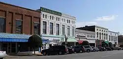 Talladega Courthouse Square Historic District | |
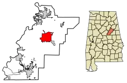 Location of Talladega in Talladega County, Alabama. | |
| Coordinates: 33°26′5″N 86°6′5″W | |
| Country | United States |
| State | Alabama |
| County | Talladega |
| Government | |
| • Mayor | Timothy Ragland[1][2][3][4] |
| Area | |
| • Total | 25.59 sq mi (66.27 km2) |
| • Land | 25.50 sq mi (66.06 km2) |
| • Water | 0.08 sq mi (0.21 km2) |
| Elevation | 558 ft (170 m) |
| Population | |
| • Total | 15,676 |
| • Estimate (2019)[7] | 15,457 |
| • Density | 606.04/sq mi (233.99/km2) |
| Time zone | UTC-6 (Central (CST)) |
| • Summer (DST) | UTC-5 (CDT) |
| ZIP codes | 35160-35161 |
| Area code(s) | 256/938. |
| FIPS code | 01-74592 |
| GNIS feature ID | 0160707 |
| Website | www |
The city is home to the Alabama Institute for the Deaf and Blind and the Talladega Municipal Airport, a public general aviation airport. The Talladega Superspeedway, Talladega College and the International Motorsports Hall of Fame are located nearby. The First National Bank of Talladega (now First Bank of Alabama) is the oldest bank in the State of Alabama, being founded in 1848.
The name Talladega is derived from a Muscogee (Creek) Native American word Tvlvtēke, from the Creek tvlwv, meaning "town", and vtēke, meaning "border" – indicating its location on the border between the Creeks and the Natchez.[11] While the town's name is pronounced /ˌtæləˈdɪɡə/ by local inhabitants, the racetrack's name is pronounced /ˌtæləˈdeɪɡə/ by auto racing fans.
Geography
Talladega is located in east central Alabama at 33° 26′ 5″ N, 86° 6′ 5″ W (33.434722 N, -86.101389 W).[12] Alabama State Routes 21, 77, and 275 are the main routes through the city. AL-77 runs through the downtown area from north to south, leading north 14 mi (23 km) to Lincoln along Interstate 20 and southeast 24 mi (39 km) to Ashland. AL-21 runs from southwest to northeast through the city, leading northeast 23 mi (37 km) to Oxford and southwest 21 mi (34 km) to Sylacauga. AL-275 runs to the north and west of the city as a bypass of the downtown area.
According to the U.S. Census Bureau, the city has a total area of 24.1 square miles (62.3 km2), of which 24.0 square miles (62.1 km2) is land and 0.077 square miles (0.2 km2), or 0.30%, is water.[10]
Climate
The climate in this area is characterized by hot, humid summers and generally mild to cool winters. According to the Köppen Climate Classification system, Talladega has a humid subtropical climate, abbreviated "Cfa" on climate maps.[13]
The data below were accessed via the WRCC. They were compiled over the time period from 1888 to when this chart was created (July 2018).[14]
Talladega's record high of 109 °F (42.8 °C) occurred in September 1925 (Alabama's record high of 112 °F was recorded in Centreville that same month), July 1930, June 1931, and July 1933. The record low of -10 °F (-23.3 °C) occurred in February 1899.[14]
| Climate data for Talladega, AL | |||||||||||||
|---|---|---|---|---|---|---|---|---|---|---|---|---|---|
| Month | Jan | Feb | Mar | Apr | May | Jun | Jul | Aug | Sep | Oct | Nov | Dec | Year |
| Record high °F (°C) | 80 (27) |
84 (29) |
90 (32) |
98 (37) |
98 (37) |
109 (43) |
109 (43) |
107 (42) |
109 (43) |
99 (37) |
89 (32) |
80 (27) |
109 (43) |
| Mean maximum °F (°C) | 71.2 (21.8) |
75.2 (24.0) |
82.0 (27.8) |
87.3 (30.7) |
92.0 (33.3) |
96.6 (35.9) |
98.2 (36.8) |
97.5 (36.4) |
94.6 (34.8) |
87.5 (30.8) |
79.7 (26.5) |
72.3 (22.4) |
99.6 (37.6) |
| Average high °F (°C) | 55.8 (13.2) |
59.4 (15.2) |
67.6 (19.8) |
75.8 (24.3) |
83.0 (28.3) |
89.5 (31.9) |
91.3 (32.9) |
90.8 (32.7) |
86.2 (30.1) |
76.5 (24.7) |
65.8 (18.8) |
57.2 (14.0) |
74.9 (23.8) |
| Average low °F (°C) | 33.7 (0.9) |
35.4 (1.9) |
42.3 (5.7) |
48.9 (9.4) |
56.9 (13.8) |
64.6 (18.1) |
68.0 (20.0) |
67.3 (19.6) |
61.9 (16.6) |
49.7 (9.8) |
40.1 (4.5) |
34.9 (1.6) |
50.3 (10.2) |
| Mean minimum °F (°C) | 13.8 (−10.1) |
17.0 (−8.3) |
23.5 (−4.7) |
31.5 (−0.3) |
41.5 (5.3) |
53.6 (12.0) |
59.5 (15.3) |
58.5 (14.7) |
47.5 (8.6) |
32.6 (0.3) |
22.4 (−5.3) |
17.4 (−8.1) |
10.4 (−12.0) |
| Record low °F (°C) | −5 (−21) |
−10 (−23) |
6 (−14) |
21 (−6) |
32 (0) |
39 (4) |
48 (9) |
46 (8) |
35 (2) |
23 (−5) |
5 (−15) |
0 (−18) |
−10 (−23) |
| Average precipitation inches (mm) | 5.20 (132) |
5.37 (136) |
6.44 (164) |
4.70 (119) |
3.96 (101) |
4.38 (111) |
4.90 (124) |
4.21 (107) |
3.42 (87) |
2.85 (72) |
3.82 (97) |
4.84 (123) |
54.09 (1,373) |
| Average snowfall inches (cm) | 1.0 (2.5) |
0.4 (1.0) |
0.4 (1.0) |
0.1 (0.25) |
0 (0) |
0 (0) |
0 (0) |
0 (0) |
0 (0) |
0 (0) |
0 (0) |
0.2 (0.51) |
2.1 (5.26) |
| Source: https://wrcc.dri.edu/cgi-bin/cliMAIN.pl?al8024 | |||||||||||||
Demographics
| Historical population | |||
|---|---|---|---|
| Census | Pop. | %± | |
| 1850 | 1,320 | — | |
| 1870 | 1,933 | — | |
| 1880 | 1,233 | −36.2% | |
| 1890 | 2,063 | 67.3% | |
| 1900 | 5,056 | 145.1% | |
| 1910 | 5,854 | 15.8% | |
| 1920 | 6,546 | 11.8% | |
| 1930 | 7,596 | 16.0% | |
| 1940 | 9,298 | 22.4% | |
| 1950 | 13,134 | 41.3% | |
| 1960 | 17,742 | 35.1% | |
| 1970 | 17,662 | −0.5% | |
| 1980 | 19,128 | 8.3% | |
| 1990 | 18,175 | −5.0% | |
| 2000 | 15,143 | −16.7% | |
| 2010 | 15,676 | 3.5% | |
| 2019 (est.) | 15,457 | [7] | −1.4% |
| U.S. Decennial Census[15] | |||
At the 2000 census, there were 15,143 people in 5,836 households, including 3,962 families, in the city. The population density was 634.4 people per square mile (244.9/km2). There were 6,457 housing units at an average density of 270.5 per square mile (104.4/km2). The racial makeup of the city was 56.15% White, 42.28% Black or African American, 0.18% Native American, 0.30% Asian, 0.02% Pacific Islander, 0.37% from other races, and 0.70% from two or more races. 0.90% of the population were Hispanic or Latino of any race.
Of the 5,836 households 30.0% had children under the age of 18 living with them, 43.7% were married couples living together, 19.7% had a female householder with no husband present, and 32.1% were non-families. 29.5% of households were one person and 13.2% were one person aged 65 or older. The average household size was 2.42 and the average family size was 2.97.
The age distribution was 25.6% under the age of 18, 10.6% from 18 to 24, 25.2% from 25 to 44, 22.8% from 45 to 64, and 15.8% 65 or older. The median age was 37 years. For every 100 females, there were 85.2 males. For every 100 females age 18 and over, there were 79.0 males.
The median household income was $29,617 and the median family income was $36,296. Males had a median income of $27,951 versus $21,326 for females. The per capita income for the city was $15,733. About 14.1% of families and 19.0% of the population were below the poverty line, including 28.4% of those under age 18 and 17.5% of those age 65 or over.
2010 census
At the 2010 census, there were 15,676 people in 5,719 households, including 3,722 families, in the city. The population density was 653.2 people per square mile (252.4/km2). There were 6,611 housing units at an average density of 275.5 per square mile (106.5/km2). The racial makeup of the city was 48.7% Black or African American, 47.7% White, 0.3% Native American, 0.5% Asian, 0% Pacific Islander, 1.6% from other races, and 1.2% from two or more races. 3.4% of the population were Hispanic or Latino of any race.
Of the 5,719 households 26.6% had children under the age of 18 living with them, 36.0% were married couples living together, 23.9% had a female householder with no husband present, and 34.9% were non-families. 30.9% of households were one person and 12.0% were one person aged 65 or older. The average household size was 2.40 and the average family size was 2.96.
The age distribution was 23.2% under the age of 18, 10.8% from 18 to 24, 25.6% from 25 to 44, 25.9% from 45 to 64, and 14.5% 65 or older. The median age was 37.4 years. For every 100 females, there were 95.0 males. For every 100 females age 18 and over, there were 102.7 males.
The median household income was $32,449 and the median family income was $38,147. Males had a median income of $31,957 versus $24,209 for females. The per capita income for the city was $15,146. About 22.7% of families and 25.5% of the population were below the poverty line, including 38.8% of those under age 18 and 19.0% of those age 65 or over.
Landmarks and places of interest
Talladega includes a number of properties listed on the National Register of Historic Places, including the J. L. M. Curry House and Swayne Hall, both listed as National Historic Landmarks.[16][17] The main listed historic districts are the Silk Stocking District, which includes the Dr. Samuel Welch House, Talladega College Historic District, and Talladega Courthouse Square Historic District.[18] Also included is the Talladega Superspeedway, which is a 2.66 miles (4.28 km) long race track. It hosts two NASCAR races annually. In 2020, the Dr. William R. Harvey Museum of Art opened at Talladega College.
Notable people
- Steadham Acker, pioneer aviator
- Tom Bleick, former NFL player, who played college football at Georgia Tech
- The original members of the gospel group The Blind Boys of Alabama met in Talladega at the Alabama School for the Blind
- Sydney J. Bowie, former U.S. Representative and nephew of Franklin Welsh Bowdon
- Taul Bradford, former U.S. Representative
- Robert Bradley grew up in Evergreen, Alabama, and attended school in Talladega at the Alabama School for the Blind. He is now a famous blues-rock artist fronting his band, Robert Bradley's Blackwater Surprise. His early performances were in churches around Talladega.
- William W. Brandon, Governor of Alabama from 1923–1927[19]
- Charles Brown, actor and member of the Negro Ensemble Company
- Ethlyne Clair, actress
- George Cruikshank, educator, newspaper editor, and historian
- Marcus Henderson Cruikshank, former member of the Confederate States Congress and Mayor of Talladega
- Lee de Forest was not a native of Talladega but he spent most of his early life there. De Forest, who invented the vacuum tube and held over 300 patents, was the son of a president of Talladega College.
- Ahmad Gooden, NFL football player
- Tinsley R. Harrison, founding editor of Harrison's Principles of Internal Medicine
- Bob Jenkins, football halfback
- Eddie King, was born on April 21, 1938, in Talladega, and played as a sideman to many other blues musicians including Sonny Boy Williamson II and Koko Taylor. His 1997 solo album, Another Cow's Dead, won the Blues Music Award.
- Herman H. Long, former president of Talladega College and former president of the United Negro College Fund
- Lamar Looney, Oklahoma state senator
- Felix Grundy McConnell, former U.S. Representative
- Gertrude Michael, film, stage and television actress. Her best-remembered role is probably Rita Ross in Murder at the Vanities (1934), one of the last pre-Code films, in which she sang an ode to marijuana ("Sweet Marijuana").
- Jack Nelson, Pulitzer-winning Washington correspondent and former Washington bureau chief for the Los Angeles Times, was born in Talladega in October 1929. Beginning in September 2007, the Reporters Committee for Freedom of the Press offered one-year fellowships for recent law school graduates. They honor Nelson, who was chairman of its executive committee and served on its steering committee for 25 years.
- Dixie Parsons, former Major League Baseball player
- Lewis E. Parsons, not a native, but moved there in 1840. Governor of Alabama from June to December 1865
- Thomas S. Plowman, former U.S. Representative and Mayor of Talladega
- Dave Pope, former Major League Baseball outfielder
- Tom Ragland, former Major League Baseball second baseman
- George Scales, Negro league baseball player
- Frank Sillmon, former basketball player and SWAC Player of the Year (1986)
- Charles Lynwood Smith, Jr., senior United States federal judge
- Bennie Swain, former basketball player for the Boston Celtics
- W. Aubrey Thomas, U.S. Representative from Ohio
- Robert Smith Vance was born in Talladega in 1931 and spent his early childhood there. He became a progressive voice in Alabama politics during the 1960s and was appointed to a federal judgeship on the United States Court of Appeals for the Eleventh Circuit
Gallery
 Aerial photo of Talladega Superspeedway in 2007
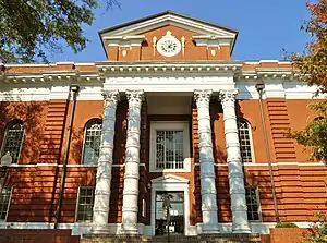 The Talladega County Courthouse is located in Talladega.
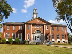 Savery Library on the campus of Talladega College, which is Alabama's oldest private historically black college.
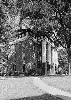 Built in 1857, and eventually named for General Wager Swayne, Swayne Hall is the oldest building on the campus of Talladega College. It was placed on the National Register of Historic Places on December 2, 1974.
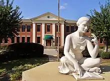 The Alabama Institute for the Deaf and Blind is a school for people with blindness and/or deafness located in Talladega.
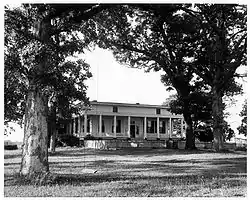 The J. L. M. Curry House was added to the National Register of Historic Places on October 15, 1966.
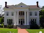 Talladega is home to the famous Silk Stocking District. The neighborhood was added to the National Register of Historic Places on December 13, 1979.
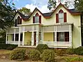 Boxwood was added to the National Register of Historic Places on June 9, 1983.
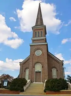 The First Presbyterian church was added to the National Register of Historic Places on November 17, 1983.
.jpg.webp) The Lawler-Whiting House was added to the National Register of Historic Places on May 22, 1986.
The Lawler-Whiting House was added to the National Register of Historic Places on May 22, 1986.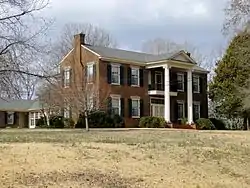 The Idlewild Plantation House was built in 1843, and it was added to the National Register of Historic Places on October 15, 1993.
.jpg.webp) Thornhill was added to the National Register of Historic Places on February 20, 1998.
Thornhill was added to the National Register of Historic Places on February 20, 1998.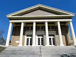 The First United Methodist Church was built in 1921.
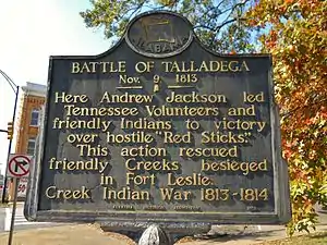 A historic marker commemorating General Andrew Jackson's victory over the Red Sticks at the Battle of Talladega during the Creek War.
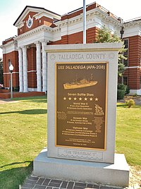 A monument to the accomplishments of the USS Talladega stands in the Talladega Historic Courthouse Square.
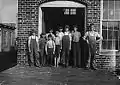 A group of doffers working in Cotton Factory posed by the superintendent of the factory. November 1910. Photographed by Lewis Hine.
References
- https://www.wsfa.com/2019/11/05/talladega-swears-first-black-mayor/
- https://abc3340.com/news/local/talladega-swears-in-first-african-american-mayor
- https://www.annistonstar.com/the_daily_home/free/history-made-talladega-elects-its-first-african-american-mayor-with/article_42836c8c-ea43-11e9-badf-8b3ce4b52cc9.html
- https://atlantablackstar.com/2019/10/09/alabama-man-tim-ragland-makes-double-history-as-youngest-and-first-black-mayor-of-talladega-alabama/
- "2019 U.S. Gazetteer Files". United States Census Bureau. Retrieved June 29, 2020.
- "Population Estimates". United States Census Bureau. Retrieved 2014-06-07.
- "Population and Housing Unit Estimates". United States Census Bureau. May 24, 2020. Retrieved May 27, 2020.
- "Find a County". National Association of Counties. Retrieved 2011-06-07.
- Herbert J. "Jim" Lewis, Birmingham, Alabama. "Talladega". Encyclopedia of Alabama. Retrieved 2016-07-25.CS1 maint: multiple names: authors list (link)
- "Geographic Identifiers: 2010 Demographic Profile Data (G001): Talladega city, Alabama". U.S. Census Bureau, American Factfinder. Archived from the original on February 12, 2020. Retrieved January 22, 2013.
- Joel A. Nevis (2006). "From Arbacoochee to Yazoo: Conjuring Up Consonants In Muskogean Place-Names Of The South" (PDF). New York City. p. 8.
- https://geohack.toolforge.org/geohack.php?pagename=Talladega,_Alabama¶ms=33_26_5_N_86_6_5_W_region:US-AL_type:city(15676)
- "Talladega, Alabama Köppen Climate Classification". Weatherbase.com. Retrieved 2016-07-25.
- "TALLADEGA, ALABAMA - Climate Summary". wrcc.dri.edu. Retrieved 2018-07-21.
- United States Census Bureau. "Census of Population and Housing". Census.gov. Retrieved November 20, 2013.
- "Curry, J. L. M., Home". National Historic Landmark summary listing. National Park Service. Archived from the original on 2011-06-06. Retrieved 2011-04-12.
- "Swayne Hall, Talladega College". National Historic Landmark summary listing. National Park Service. Archived from the original on 2008-02-10. Retrieved 2007-10-25.
- "National Register Information System". National Register of Historic Places. National Park Service. January 23, 2007.
- "Alabama Governor William Woodward Brandon". National Governors Association. Retrieved Aug 29, 2013.
External links
- City of Talladega official website
- Talladega in the Encyclopedia of Alabama
- . The American Cyclopædia. 1879.
- . Encyclopædia Britannica (11th ed.). 1911.
- . . 1914.
Municipalities and communities of Talladega County, Alabama, United States | ||
|---|---|---|
| Cities | 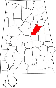 Map of Alabama highlighting Talladega County | |
| Towns | ||
| CDPs | ||
| Unincorporated communities | ||
| Ghost town | ||
| Footnotes | ‡This populated place also has portions in an adjacent county or counties | |
| ||
| Authority control |
|---|