Tanana River
The Tanana River /ˈtænənɑː/ (Upper Tanana: Tth’iitu’ Niign) is a 584-mile (940 km) tributary of the Yukon River in the U.S. state of Alaska.[n 1] According to linguist and anthropologist William Bright, the name is from the Koyukon (Athabaskan) tene no, tenene, literally "trail river".[7]
| Tanana River | |
|---|---|
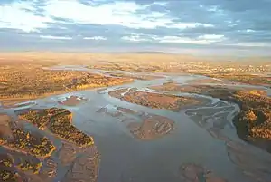
 Tanana River near Fairbanks, Alaska | |
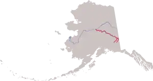
 Course of the Tanana River, formed by the shorter Nabesna River (left) and Chisana River (right), then flowing northwest to meet the Yukon River | |
| Etymology | from the Koyukon (Athabaskan) tene no, tenene, meaning "trail river". |
| Native name | Tth’iitu’ Niign |
| Location | |
| Country | United States |
| State | Alaska |
| District | Southeast Fairbanks Census Area, Fairbanks North Star Borough, Yukon-Koyukuk Census Area |
| Physical characteristics | |
| Source | confluence of the Nabesna and Chisana rivers |
| • location | Northway Junction, Tetlin National Wildlife Refuge |
| • coordinates | 63°02′57″N 141°51′52″W[1] |
| • elevation | 1,672 ft (510 m)[2] |
| Mouth | Yukon River |
• location | near Tanana |
• coordinates | 65°09′38″N 151°57′37″W[1] |
• elevation | 200 ft (61 m)[1] |
| Length | 584 mi (940 km) |
| Basin size | 44,000 sq mi (110,000 km2)[3] |
| Discharge | |
| • location | mouth[3] |
| • average | 41,800 cu ft/s (1,180 m3/s)[3] |
The river's headwaters are located at the confluence of the Chisana and Nabesna rivers just north of Northway in eastern Alaska.[8] The Tanana flows in a northwest direction from near the border with the Yukon Territory, and laterally along the northern slope of the Alaska Range, roughly paralleled by the Alaska Highway.[8] In central Alaska, it emerges into a lowland marsh region known as the Tanana Valley and passes south of the city of Fairbanks.[8]
In the marsh regions it is joined by several large tributaries, including the Nenana (near the city of Nenana) and the Kantishna. It passes the village of Manley Hot Springs and empties into the Yukon near the town of Tanana.[8]
Ice on the river accumulates each winter to an average maximum thickness of 43 inches (110 cm) at Nenana.[9] The Nenana Ice Classic, begun in 1917, is an annual guessing game about the date of the ice break-up.[9] In October or November, after the freeze has begun, a tripod is planted in ice in the middle of the river. The tripod is connected to an on-shore clock that stops when the tripod begins to move during the spring thaw. Over the years, the break-up date has varied from April 20 to May 20.[9] Betting on the exact time of the break-up takes the form of a lottery, called the Nenana Ice Classic.
History
Human habitation of the Yukon basin, including the Tanana watershed, began more than 12,000 years ago.[10] Several sites in the watershed have produced evidence of occupation by Paleo-Arctic people. Later residents include people of the Tanana tribe, which has had a presence in the region for 1,200 years.[10]
In the summer of 1885, Lieutenant Henry Tureman Allen of the U.S. Army undertook the first recorded exploration of the Tanana River. In 1883, Lieutenant Frederick Schwatka and his party had entered the Yukon watershed by way of Canada and floated to the mouth of the Yukon. Allen's goal was to find an all-Alaska route to the Yukon River. He and his men ascended the Copper River, crossed into Tanana River drainage, and descended the Tanana to the Yukon and down it to the mouth. During the five-month trip, the Allen party mapped the courses of the Copper, Tanana, and Koyukuk rivers.[11]
In the early 21st century, the basin is largely wilderness unchanged by human activity. Fairbanks, a metropolitan area with about 100,000 residents in 2019, is a center of placer gold mining, which has continued in the basin since the mid-19th century. Limited farming also occurs in the valley near Fairbanks.[10]
Nenana Ice Classic
Since the early 1900s, Alaskans have been gambling on when the river would melt. Each year, thousands pay $2.50 to guess the exact date and minute the Tanana River ice will go out in Nenana. The Nenana Ice Classic is a fundraiser for local charities and has awarded some large prizes. In 2010, after the ice went out on April 29, three lottery winners split a jackpot of $279,030.[12] In 2012, the record prize was $350,000.[13]
Major tributaries (in descending order of elevation)


- Chisana River
- Nabesna River
- Kalutna River
- Tok River
- Robertson River
- Johnson River
- Little Gerstle River
- Healy River
- Volkmar River
- Gerstle River
- Clearwater Creek
- Goodpaster River
- Delta River
- Delta Creek
- Little Delta River
- Salcha River
- Little Salcha River
- Chena River
- North Fork
- South Fork
- Wood River
- Tatlanika River
- Nenana River
- Teklanika River
- Seventeen Mile Slough
- Tolovana River
- Kantishna River
- Zitziana River
- Cosna River
- Chitanana River
Notes and references
- Notes
- The main-stem length is calculated by subtracting the length of the Nabesna River from the length, 659 mi (1,061 km), listed by J.C. Kammerer in "Largest Rivers in the United States".[4] The Nabesna River is roughly 75 mi (121 km) long, calculated by adding the 60 mi (97 km) from the Nabesna mouth to Camp Creek[5] to the distance, 15 mi (24 km), from Camp Creek to Nabesna Glacier,[6] Kammerer's most remote source for the Tanana.
- References
- "Tanana River". Geographic Names Information System. United States Geological Survey. January 1, 2000. Retrieved April 28, 2011.
- Source elevation derived from Google Earth search using GNIS source coordinates.
- Benke and Cushing, p. 797
- Kammerer, J.C. (September 1, 2005). "Largest Rivers in the United States". United States Geological Survey. Archived from the original on January 29, 2017. Retrieved April 28, 2011.
- Irwin, Thomas (October 3, 2005). "Recordable Disclaimer of Interest Application for the Nabesna River" (PDF). U.S. Bureau of Land Management. Archived from the original (PDF) on October 19, 2012. Retrieved February 19, 2011.
- Alaska Atlas and Gazetteer (Map) (7th ed.). DeLorme. 2010. p. 98. ISBN 0-89933-289-7.
- Bright, William (2004). Native American placenames of the United States. University of Oklahoma Press. p. 478. ISBN 978-0-8061-3598-4. Retrieved 11 April 2011.
- Alaska Atlas and Gazetteer (Map) (7th ed.). DeLorme. 2010. pp. 107–09, 112–17, 122. ISBN 0-89933-289-7.
- "Nenana Ice Classic: Tanana River Ice Annual Breakup Dates". National Snow and Ice Data Center. Archived from the original on March 14, 2011. Retrieved April 28, 2011.
- Benke and Cushing, p. 787
- "America's Territory: Exploration and Mapping of Alaska's Land". Alaska Humanities Forum. Archived from the original on March 4, 2016. Retrieved April 28, 2011.
- "Push begins for online Ice Classic ticket sales". Fairbanks Daily News-Miner. Juneau Empire. April 3, 2011. Archived from the original on December 3, 2011. Retrieved April 28, 2011.
- "Archived copy". Archived from the original on 2013-12-02. Retrieved 2013-11-26.CS1 maint: archived copy as title (link)
Works cited
- Benke, Arthur C., ed., and Cushing, Colbert E., ed. (2005). Rivers of North America. Burlington, Massachusetts: Elsevier Academic Press. ISBN 0-12-088253-1.
