Taperoá, Bahia
The municipality contains part of the 230,296 hectares (569,070 acres) Caminhos Ecológicos da Boa Esperança Environmental Protection Area, created in 2003.[4]
Taperoá | |
|---|---|
| Municipality of Taperoá | |
| Nickname(s): Princesa do sertão | |
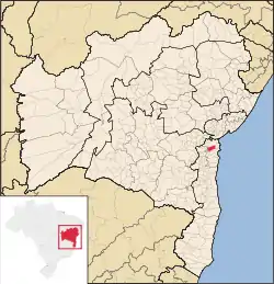 Localization of the city | |
| Country | Brazil |
| Region | Northeast |
| State | Bahia |
| Government | |
| • Mayor | Toinho do Banco (PT) |
| Area | |
| • Total | 454.081 km2 (175.322 sq mi) |
| [1] | |
| Elevation | 286 m (938 ft) |
| Population (2020 [2]) | |
| • Total | 21,253 |
| • Density | 45.64/km2 (118.2/sq mi) |
| Time zone | UTC-3 (UTC-3) |
| Postal Code | 44000-000 |
| Area code(s) | +55 75 |
| HDI (2010) | 0.566 – medium[3] |
Taperoá is a municipality in Bahia, Brazil.
References
- IBGE (10 October 2002). "Área territorial oficial". Resolução da Presidência do IBGE de n° 5 (R.PR-5/02). Retrieved 5 December 2010.
- IBGE 2020
- "Ranking decrescente do IDH-M dos municípios do Brasil". Atlas do Desenvolvimento Humano. Programa das Nações Unidas para o Desenvolvimento (PNUD). 2010. Retrieved 16 August 2013.
- Souto, Paulo; Khoury, Jorge (5 June 2003), Decreto nº 8.552 de 05 de junho de 2003 (in Portuguese), Estado da Bahia, retrieved 2016-10-26
This article is issued from Wikipedia. The text is licensed under Creative Commons - Attribution - Sharealike. Additional terms may apply for the media files.