Tech (river)
The Tech (French: [tɛk]; Catalan: Tec [ˈtɛk]) is a river in southern France, very close to the French-Spanish border. It runs through a valley in the Pyrénées-Orientales, in the former Roussillon, and is 84.5 kilometres (52.5 mi) long.[1] Its source is the Parcigoule Valley, elevation 2,500 metres (8,200 ft), and it feeds the Mediterranean Sea. At Céret, the medieval Devil's bridge, once the largest bridge arch in the world, spans the river in an arc of 45 metres (148 ft) in length.
| Tech | |
|---|---|
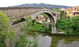 Pont du Diable, spanning the Tech, in Céret | |
| Location | |
| Country | France |
| Physical characteristics | |
| Source | |
| • location | Pyrenees |
| • elevation | ±2,500 m (8,200 ft) |
| Mouth | |
• location | Mediterranean Sea |
• coordinates | 42°35′24″N 3°2′43″E |
| Length | 84.5 km (52.5 mi) |
| Basin size | 750 km2 (290 sq mi) |
| Discharge | |
| • average | 9.6 m3/s (340 cu ft/s) |
Geography
The Tech flows through 25 different towns, from its source to the sea: Prats-de-Mollo-la-Preste, Serralongue, Le Tech, Saint-Laurent-de-Cerdans, Montferrer, Corsavy, Arles-sur-Tech, Montbolo, Amélie-les-Bains-Palalda, Reynès, Céret, Saint-Jean-Pla-de-Corts, Maureillas-las-Illas, Le Boulou, Tresserre, Saint-Génis-des-Fontaines, Montesquieu-des-Albères, Banyuls-dels-Aspres, Villelongue-dels-Monts, Brouilla, Ortaffa, Palau-del-Vidre, Elne and Argelès-sur-Mer. It flows into the Mediterranean Sea between Saint-Cyprien and Argelès-sur-Mer, southeast of Perpignan.[2]
In culture
- Poetry
- (in French) Ode au Tech [Ode to the Tech] (1912), a poem by the writer Marc Anfossi.[3]
References
- Sandre. "Fiche cours d'eau - Le Tech (Y02-0400)".
- IGN Map on www.geoportail.fr
- (in French) Fabricio Cardenas, Vieux papiers des Pyrénées-Orientales, Ode au Tech en 1912, 29 May 2015
External links
| Wikimedia Commons has media related to Tech (fleuve). |
- Cotrim da Cunha, Leticia, Léon Serve, François Gadel and Jean-Louis Blazi (September 1998). "Lignin-derived phenolic compounds as indicators of the nature of particulate organic matter in a Mediterranean river, the Tech". 2nd International Electronic Conference on Synthetic Organic Chemistry. Archived from the original on 2007-09-29. Retrieved 2007-01-27.