Le Tech
Le Tech (Catalan: El Tec) is a commune in the Pyrénées-Orientales department in southern France. It is part of the historical Vallespir comarca.
Le Tech
El Tec | |
|---|---|
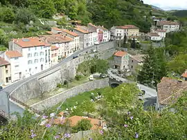 An overall view of Le Tech | |
Location of Le Tech 
| |
 Le Tech  Le Tech | |
| Coordinates: 42°24′41″N 2°32′42″E | |
| Country | France |
| Region | Occitanie |
| Department | Pyrénées-Orientales |
| Arrondissement | Céret |
| Canton | Le Canigou |
| Intercommunality | Haut Vallespir |
| Government | |
| • Mayor (2014–2020) | Guillaume Cervantes |
| Area 1 | 25.18 km2 (9.72 sq mi) |
| Population (2017-01-01)[1] | 95 |
| • Density | 3.8/km2 (9.8/sq mi) |
| Time zone | UTC+01:00 (CET) |
| • Summer (DST) | UTC+02:00 (CEST) |
| INSEE/Postal code | 66206 /66230 |
| Elevation | 420–2,721 m (1,378–8,927 ft) (avg. 520 m or 1,710 ft) |
| 1 French Land Register data, which excludes lakes, ponds, glaciers > 1 km2 (0.386 sq mi or 247 acres) and river estuaries. | |
Geography
Localisation
Le Tech is located east of Prats-de-Mollo-la-Preste, in the canton of Le Canigou and in the arrondissement of Céret..
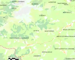
Map of Le Tech and its surrounding communes
Neighbouring communes
Places adjacent to Le Tech | |
|---|---|
Land relief
Elevation ranges from 420 to 2721 meters.
Hydrography
The territory of Le Tech is shaped by the valley of the river Coumelade and the village itself is located at the confluence of the Coumelade and the river Tech.
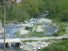
Confluence of the Coumelade and the Tech
Toponymy
Le Tech takes its name from the Tech river which runs through the village.
History
The commune of Le Tech was created on March 19, 1862, by a piece of territory being separated from Prats-de-Mollo.[2]
Government and politics
Mayors
| Mayor | Term start | Term end |
|---|---|---|
| Jean-Michel Coste | 1971 | 1980 |
| Raphaël Sales | 1980 | 1989 |
| Roger Gineste | 1989 | ? |
| Claude Puitg | 2001 | 2008 |
| Guillaume Cervantes | 2008 |
Population
|
| |||||||||||||||||||||||||||||||||||||||||||||||||||||||||||||||||||||||||||||||||
| Source: EHESS[3] and INSEE[4] | ||||||||||||||||||||||||||||||||||||||||||||||||||||||||||||||||||||||||||||||||||
Sites of interest
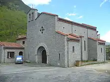
The new Saint Mary church
- Saint Mary church : the ancient church from the 17th c., located near the river, was destroyed by floods in 1940 and a new one was then built above the village.
- St Guillem of Combret Hermitage
- Sainte Cécile de Cos church
- Cos tower
- Saint Côme et Saint-Damien de La Llau church
References
- "Populations légales 2017". INSEE. Retrieved 6 January 2020.
- Jean-Pierre Pélissier, Paroisses et communes de France : dictionnaire d'histoire administrative et démographique, vol. 66 : Pyrénées-Orientales, Paris, CNRS, 1986, 378 p. (ISBN 2-222-03821-9)
- Données Cassini, EHESS
- Population en historique depuis 1968, INSEE
| Wikimedia Commons has media related to Le Tech. |
| Authority control |
|
|---|
This article is issued from Wikipedia. The text is licensed under Creative Commons - Attribution - Sharealike. Additional terms may apply for the media files.