Teufel's Farm Strip
Teufel's Farm Strip (FAA LID: OR80) was a private airport southeast of Hillsboro in Washington County, Oregon, United States. In 2002 the property containing Teufel's Farm was rezoned to make way for the Arbor Homes Oregon Roses neighborhood.[1]
Teufel's Farm Strip | |||||||||||
|---|---|---|---|---|---|---|---|---|---|---|---|
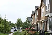 2009 picture showing residences at location of the former airport | |||||||||||
| Summary | |||||||||||
| Airport type | Closed | ||||||||||
| Location | Hillsboro, Oregon | ||||||||||
| Elevation AMSL | 200 ft / 60 m | ||||||||||
| Coordinates | 45°30′34″N 122°58′16″W | ||||||||||
| Website | teufelhollyfarms.com | ||||||||||
| Runways | |||||||||||
| |||||||||||
| Helipads | |||||||||||
| |||||||||||
External links
- Resources for this airport:
- FAA airport information for OR80
- AirNav airport information for OR80
- FlightAware airport information and live flight tracker
- SkyVector aeronautical chart for OR80
This article is issued from Wikipedia. The text is licensed under Creative Commons - Attribution - Sharealike. Additional terms may apply for the media files.