Washington County, Oregon
Washington County is one of the 36 counties in the U.S. state of Oregon. As of the 2010 United States Census, the population was 529,710,[1] making it the state's second most populous county. The county seat and largest city is Hillsboro.[2][3]
Washington County | |
|---|---|
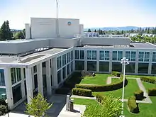
 _(washDA0034).jpg.webp) _(washDA0035).jpg.webp) From top, left to right: Washington County courthouse, Meier Road Barn, a canola field in rural Washington County | |
Seal | |
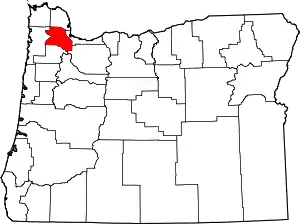 Location within the U.S. state of Oregon | |
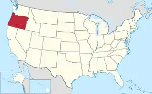 Oregon's location within the U.S. | |
| Coordinates: 45°34′N 123°05′W | |
| Country | |
| State | |
| Founded | July 5, 1843 (as Twality District) |
| Seat | Hillsboro |
| Largest city | Hillsboro |
| Area | |
| • Total | 726 sq mi (1,880 km2) |
| • Land | 724 sq mi (1,880 km2) |
| • Water | 2.2 sq mi (6 km2) 0.3%% |
| Population (2010) | |
| • Total | 529,710 |
| • Estimate (2019) | 601,592 |
| • Density | 826/sq mi (319/km2) |
| Time zone | UTC−8 (Pacific) |
| • Summer (DST) | UTC−7 (PDT) |
| Congressional district | 1st |
| Website | www |
Washington County is part of the Portland metropolitan area.
Cities in Washington County include Hillsboro, Beaverton, Tigard, Cornelius, Banks, Gaston, Sherwood, North Plains, and Forest Grove, the county's oldest city.[4]
Originally named Twality when created in 1843, the territorial legislature renamed it for the nation's first president in 1849. The original boundaries included the entire northwest corner of Oregon before sections became new counties. The Tualatin River and its drainage basin are almost entirely within the county, with the county nearly coterminous with the Tualatin Valley. It is bordered on the west and north by the Northern Oregon Coast Range, on the south by the Chehalem Mountains, and on the north and east by the Tualatin Mountains (or West Hills).
The county's major roads include small sections of Interstate 5 and Interstate 205, the Sunset Highway, Oregon Route 217, Oregon Route 47, Oregon Route 10, Oregon Route 6, and Oregon Route 8. Public transportation is primarily operated by TriMet and includes buses, the Westside Express Service commuter rail, and MAX Light Rail. Other transportation includes air travel at the Hillsboro Airport, private airfields and heliports, and heavy rail cargo on rail lines.
History
The Provisional Legislature of Oregon created the county as Twality District on July 5, 1843. Twality was one of the original four districts of the Provisional Government of Oregon in Oregon Country along with Clackamas, Champooick (later Marion), and Yamhill counties. Columbia, later known as Hillsboro, was selected as the county seat in 1850. Washington County lost significant portions of its original area when Columbia and Multnomah counties were created in 1854. The county area was increased by 160 acres (65 ha) in 2014 when a section of Multnomah County was attached to Washington.[5] The area was returned to Washington County to allow for property development.[6]
The construction of Canyon Road to Beaverton helped Portland to consolidate its position as the primary port of Oregon, and defeat the rival efforts of settlements such as Oregon City and Milwaukie.
In November 2004, the County and the City of Beaverton agreed to a plan where the city would annex both unincorporated residential neighborhoods as well as high-value areas of land. This would result with Cedar Hills, Garden Home, Raleigh Hills, West Slope being incorporated by 2010, and the communities of Aloha, Bethany, and Cedar Mill at some point after that.
Those plans have since been put on hold after Beaverton attempted to annex Nike, Inc.'s World Headquarters, which would have increased Nike's taxes substantially. Nike successfully lobbied the legislature for a law that would prohibit their annexation for 99 years. Since that decision, annexation plans have been halted, and Washington County started urban planning to provide city-level services to the unincorporated urban areas in the county.[7]
Geography
According to the US Census Bureau, the county has a total area of 726 square miles (1,880 km2), of which 724 square miles (1,880 km2) is land and 2.2 square miles (5.7 km2) (0.3%) is water.[8] It is located approximately 20 miles (32 km) to the west of Portland. The Portland Metro Urban Growth Boundary (UGB) bisects the county. The county's highest point is South Saddle Mountain at 3,464 feet (1,056 m) above sea level in the Northern Oregon Coast Range.[9]
Most of the county is in the Tualatin Valley, formed by the Tualatin Mountains to the east and north, the Chehalem Mountains to the south, and the Northern Oregon Coast Range to the west and north. The county's only river is the Tualatin River, flowing through the Tualatin Plains. The northern and western portions of the county are forested, while the remainder of the county includes urban areas, agricultural lands, and floodplains.[10]
Waterways
The Tualatin River is the main river in Washington County. Henry Hagg Lake, southwest of Forest Grove, is the largest lake. The Willamette River lies to the east, the Columbia River to the northeast, and the Pacific Ocean to the west of the county.
Adjacent counties
- Clatsop County - northwest
- Columbia County - north
- Multnomah County - east
- Clackamas County - southeast
- Yamhill County - south
- Tillamook County - west
Major highways
 Interstate 5 (freeway)
 Interstate 205 (freeway)
 U.S. Route 26 (freeway for part)
 Oregon Route 6
 Oregon Route 8
 Oregon Route 10
 Oregon Route 47
 Oregon Route 99W
 Oregon Route 210
 Oregon Route 217 (freeway)
 Oregon Route 219
National protected areas
Demographics
| Historical population | |||
|---|---|---|---|
| Census | Pop. | %± | |
| 1850 | 2,652 | — | |
| 1860 | 2,801 | 5.6% | |
| 1870 | 4,261 | 52.1% | |
| 1880 | 7,082 | 66.2% | |
| 1890 | 11,972 | 69.0% | |
| 1900 | 14,467 | 20.8% | |
| 1910 | 21,522 | 48.8% | |
| 1920 | 26,376 | 22.6% | |
| 1930 | 30,275 | 14.8% | |
| 1940 | 39,194 | 29.5% | |
| 1950 | 61,269 | 56.3% | |
| 1960 | 92,237 | 50.5% | |
| 1970 | 157,920 | 71.2% | |
| 1980 | 245,808 | 55.7% | |
| 1990 | 311,554 | 26.7% | |
| 2000 | 445,342 | 42.9% | |
| 2010 | 529,710 | 18.9% | |
| 2019 (est.) | 601,592 | [11] | 13.6% |
| US Decennial Census[12] 1790-1960[13] 1900-1990[14] 1990-2000[15] 2010-2019[1] | |||
2000 census
As of the 2000 United States Census,[16] there were 445,342 people, 169,162 households, and 114,015 families in the county. The population density was 615/sqmi (238/km2). There were 178,913 housing units at an average density of 247/sqmi (95/km2). The racial makeup of the county was 82.19% White, 1.15% Black or African American, 0.65% Native American, 6.68% Asian, 0.30% Pacific Islander, 5.86% from other races, and 3.17% from two or more races. 11.17% of the population were Hispanic or Latino of any race. 17.2% were of German, 9.9% English, 8.2% Irish, and 6.7% American ancestry. 81.7% spoke only English at home, while 9.6% spoke Spanish and 1.2% Vietnamese.
There were 169,162 households, out of which 35.60% had children under the age of 18 living with them, 54.50% were married couples living together, 9.00% had a female householder with no husband present, and 32.60% were non-families. 24.70% of all households were made up of individuals, and 6.70% had someone living alone who was 65 years of age or older. The average household size was 2.61 and the average family size was 3.14.
The county population contained 26.90% under the age of 18, 9.30% from 18 to 24, 34.10% from 25 to 44, 20.90% from 45 to 64, and 8.80% who were 65 years of age or older. The median age was 33 years. For every 100 females, there were 99.10 males. For every 100 females age 18 and over, there were 97.00 males.
The median income for a household in the county was $52,122, and the median income for a family was $61,499. Males had a median income of $43,304 versus $31,074 for females. The per capita income for the county was $24,969. About 4.90% of families and 7.40% of the population were below the poverty line, including 8.30% of those under age 18 and 5.30% of those age 65 or over.
2010 census
As of the 2010 United States Census, there were 529,710 people, 200,934 households, and 134,323 families residing in the county.[17] The population density was 731.4 inhabitants per square mile (282.4/km2). There were 212,450 housing units at an average density of 293.3 per square mile (113.2/km2).[18] The racial makeup of the county was 76.6% white, 8.6% Asian, 1.8% black or African American, 0.7% American Indian, 0.5% Pacific islander, 7.5% from other races, and 4.3% from two or more races. Those of Hispanic or Latino origin made up 15.7% of the population.[17] In terms of ancestry, 20.8% were German, 12.4% were English, 12.1% were Irish, and 3.2% were American.[19]
Of the 200,934 households, 36.0% had children under the age of 18 living with them, 52.2% were married couples living together, 10.1% had a female householder with no husband present, 33.2% were non-families, and 25.1% of all households were made up of individuals. The average household size was 2.60 and the average family size was 3.14. The median age was 35.3 years.[17]
The median income for a household in the county was $62,574 and the median income for a family was $76,778. Males had a median income of $54,417 versus $40,254 for females. The per capita income for the county was $30,522. About 6.7% of families and 9.5% of the population were below the poverty line, including 12.5% of those under age 18 and 6.7% of those age 65 or over.[20]
Government
The county is governed by an elected board of five commissioners. The county is divided into four commissioner districts. One commissioner sits for each district, and the fifth commissioner is at-large and is the Chair of the board.[21]
Politics
Like all of the Willamette Valley and Oregon Coast, Washington County was in its pre-Depression history strongly Republican. After Oregon achieved statehood in 1859, Washington County voted for the Republican Presidential nominee in every presidential election from 1860 to 1928, except in the 1912 presidential election when the county supported Progressive Party candidate and former Republican President, Theodore Roosevelt.[22] In 1932, Franklin D. Roosevelt became the first Democrat to carry the Washington County vote, and he repeated this in 1936 and 1940. Between 1944 and 1988, Washington County was never won by a Democrat except in Lyndon B. Johnson's 1964 landslide. As late as 1976, Washington County was the second-most Republican county in the state of Oregon behind remote Malheur,[23] with Gerald Ford's 17,529 vote victory in the county being decisive in carrying the state of Oregon for him during that year's Presidential election.
Since the 1990s, the increasing drift of the Republican Party nationally towards the South and evangelicalism, along with urbanization, has resulted in a strong shift of Washington County towards the Democratic Party. No Republican Presidential candidate has carried Washington County since George Bush Sr. did so in 1988, and in three of the past four Presidential elections, Barack Obama, Hillary Clinton and Joe Biden have carried the county by over twenty percentage points. The last Republican to win a statewide election in Washington County was Gordon H. Smith in the 2002 Senate contest. In the 2008 Senatorial election Democrat Jeff Merkley won 48.8 percent of the county's vote (111,367) while Republican incumbent Smith won 46.5 percent (106,114),[24] but no subsequent Republican Senate candidate has won 40 percent of the county's vote. In the 2020 presidential election, Democrat Joe Biden hit 65.5% of the county's vote, the highest ever for a Democratic presidential nominee.
| Year | Republican | Democratic | Third parties |
|---|---|---|---|
| 2020 | 30.9% 99,073 | 65.5% 209,940 | 3.5% 11,313 |
| 2016 | 30.9% 83,197 | 56.9% 153,251 | 12.2% 32,784 |
| 2012 | 39.7% 93,974 | 57.1% 135,291 | 3.3% 7,758 |
| 2008 | 37.7% 89,185 | 59.8% 141,544 | 2.5% 5,903 |
| 2004 | 46.4% 107,223 | 52.4% 121,140 | 1.3% 2,945 |
| 2000 | 46.3% 86,091 | 48.8% 90,662 | 5.0% 9,221 |
| 1996 | 40.8% 65,221 | 48.0% 76,619 | 11.2% 17,915 |
| 1992 | 34.2% 57,146 | 40.4% 67,528 | 25.4% 42,521 |
| 1988 | 51.9% 67,018 | 46.3% 59,837 | 1.8% 2,356 |
| 1984 | 62.8% 75,877 | 36.9% 44,602 | 0.3% 417 |
| 1980 | 51.3% 57,165 | 34.1% 37,915 | 14.6% 16,275 |
| 1976 | 57.8% 52,376 | 38.5% 34,847 | 3.7% 3,388 |
| 1972 | 58.4% 43,958 | 37.1% 27,890 | 4.5% 3,390 |
| 1968 | 57.0% 34,105 | 38.3% 22,943 | 4.7% 2,794 |
| 1964 | 41.5% 20,813 | 58.0% 29,081 | 0.6% 287 |
| 1960 | 58.9% 25,415 | 41.1% 17,736 | 0.1% 35 |
| 1956 | 61.1% 22,001 | 38.9% 14,027 | 0.0% 0 |
| 1952 | 64.1% 20,250 | 35.4% 11,191 | 0.5% 143 |
| 1948 | 53.1% 11,455 | 43.7% 9,424 | 3.3% 710 |
| 1944 | 50.1% 9,362 | 48.8% 9,110 | 1.1% 205 |
| 1940 | 48.9% 8,367 | 50.4% 8,626 | 0.6% 110 |
| 1936 | 30.5% 4,148 | 63.5% 8,641 | 6.1% 823 |
| 1932 | 36.3% 4,201 | 59.0% 6,824 | 4.7% 548 |
| 1928 | 62.4% 6,162 | 35.9% 3,544 | 1.8% 173 |
| 1924 | 46.0% 4,203 | 23.0% 2,103 | 31.0% 2,835 |
| 1920 | 64.7% 4,947 | 29.6% 2,262 | 5.7% 432 |
| 1916 | 56.2% 4,888 | 38.6% 3,363 | 5.2% 452 |
| 1912 | 27.1% 1,261 | 30.7% 1,429 | 42.3% 1,969 |
| 1908 | 62.0% 2,319 | 30.8% 1,153 | 7.2% 271 |
| 1904 | 73.2% 2,296 | 15.7% 492 | 11.1% 349 |
| 1900 | 56.1% 1,655 | 37.7% 1,114 | 6.0% 179 |
| 1896 | 56.1% 2,082 | 42.2% 1,566 | 1.6% 60 |
| 1892 | 53.2% 1,587 | 9.8% 293 | 36.8% 1,099 |
| 1888 | 57.9% 1,249 | 38.8% 838 | 3.2% 69 |
| 1884 | 51.2% 946 | 41.4% 766 | 7.3% 135 |
| 1880 | 58.8% 880 | 38.6% 578 | 2.4% 37 |
Economy

Washington County is centered on a fertile plain that attracted farmers before the first wagon trains. In 1997, orchards covered 8,403 acres (34 km2) of the county's lands and 1,163 acres (4.7 km2) were devoted to vineyards. Agriculture is still a major industry in Washington County, as are lumber, manufacturing, and food processing.
The development of a large electronics industry during the 1980s and 1990s is the dominating factor of the county economy. California-based Intel, Oregon's largest private for-profit employer,[26] has its largest concentration of employees in the county, mainly in Hillsboro. Other technology companies include Electro Scientific Industries, FEI Company, Qorvo, Tektronix, SolarWorld, Planar Systems, and EPSON.
Nike, one of two Fortune 500 corporations based in Oregon, has its headquarters in Washington County. Until it was acquired by IBM, Sequent Computer Systems was headquartered near Nike. Other companies with headquarters in Washington County include optical instruments manufacturer Leupold & Stevens, Columbia Sportswear, and Reser's Fine Foods.
Communities

Cities
| City | 1990 population | 2000 population | 2010 population[27] | Incorporated | Notes |
|---|---|---|---|---|---|
| Banks | 563 | 1,286 | 1,777 | 1921 | |
| Beaverton | 53,310 | 76,129 | 89,803 | 1893 | |
| Cornelius | 6,148 | 9,652 | 11,869 | 1893 | |
| Durham | 748 | 1,382 | 1,351 | 1966 | |
| Forest Grove | 13,559 | 17,708 | 21,083 | 1872 | |
| Gaston | 563 | 600 | 637 | 1914 | |
| Hillsboro | 37,520 | 70,187 | 91,611 | 1876 | County seat |
| King City | 2,060 | 1,949 | 3,111 | 1966 | |
| Lake Oswego | 30,576 | 35,278 | 36,619 | 1910 | Small portion, most in Clackamas County[28] |
| North Plains | 972 | 1,605 | 1,947 | 1963 | |
| Portland | 437,319 | 529,121 | 583,776 | 1851 | Small portion, most in Multnomah County[29] |
| Rivergrove | 294 | 324 | 289 | 1971 | Small portion, most in Clackamas County |
| Sherwood | 3,093 | 11,791 | 18,194 | 1893 | |
| Tigard | 29,344 | 41,223 | 48,035 | 1961 | |
| Tualatin | 15,013 | 22,791 | 26,054 | 1913 | Small portion also in Clackamas County |
| Wilsonville | 7,106 | 13,991 | 19,509 | 1969 | Small portion, most in Clackamas County[30] |
Census-designated places
Unincorporated communities
- Bacona
- Balm Grove
- Blooming
- Bonita
- Bonny Slope
- Bradley Corner
- Buckheaven
- Buxton
- Carnation
- Chehalem
- Cherry Grove
- Dilley
- Dixie
- Elmonica
- Farmington
- Gales Creek
- Glencoe
- Glenwood
- Hayward
- Hazeldale
- Helvetia
- Hillside
- Huber
- Kansas City
- Kinton
- Laurel
- Laurelwood
- Manning
- Marlene Village
- Middleton
- Midway
- Mountaindale
- Mulloy
- Norwood
- Orenco
- Patton
- Progress
- Reedville
- Roy
- Scholls
- Six Corners
- Somerset West
- Tanasbourne
- Thatcher
- Timber
- Tobias
- Verboort
- Watts
- West Union
- Wilkesboro
- Witch Hazel
See also
References
- "State & County QuickFacts". US Census Bureau. Archived from the original on July 22, 2011. Retrieved November 15, 2013.
- Proehl, Risa S. (March 2009). "2008 Oregon Population Report" (PDF). Population Research Center. Portland State University. p. 7. Archived from the original (PDF) on March 3, 2016. Retrieved May 5, 2009.
- "Find a County". National Association of Counties. Retrieved June 7, 2011.
- "Incorporation dates". The Hillsboro Argus. October 19, 1976. pp. Communities, p. 21.
- "Oregon Secretary of State: Washington County History". sos.oregon.gov. Retrieved April 1, 2018.
- "County welcomes Area 93 in new year". Hillsboro Tribune. January 10, 2014. Archived from the original on January 16, 2014. Retrieved January 6, 2020.
- "Appellate court rejects Beaverton annexation". The Oregonian. June 16, 2006.
- "2010 Census Gazetteer Files". US Census Bureau. August 22, 2012. Retrieved February 28, 2015.
- "South Saddle Mountain - Peakbagger.com". www.peakbagger.com. Archived from the original on April 1, 2018. Retrieved April 1, 2018.
- "Washington County OR" (Google Maps - accessed 19 October 2019)
- "Population and Housing Unit Estimates". Retrieved March 26, 2020.
- "U.S. Decennial Census". US Census Bureau. Retrieved February 28, 2015.
- "Historical Census Browser". University of Virginia Library. Retrieved February 28, 2015.
- Forstall, Richard L., ed. (March 27, 1995). "Population of Counties by Decennial Census: 1900 to 1990". US Census Bureau. Retrieved February 28, 2015.
- "Census 2000 PHC-T-4. Ranking Tables for Counties: 1990 and 2000" (PDF). US Census Bureau. April 2, 2001. Retrieved February 28, 2015.
- "U.S. Census website". US Census Bureau. Retrieved January 31, 2008.
- "Profile of General Population and Housing Characteristics: 2010 Demographic Profile Data". US Census Bureau. Archived from the original on February 13, 2020. Retrieved February 23, 2016.
- "Population, Housing Units, Area, and Density: 2010 - County". US Census Bureau. Archived from the original on February 13, 2020. Retrieved February 23, 2016.
- "Selected Social Characteristics in the US – 2006-2010 American Community Survey 5-Year Estimates". US Census Bureau. Archived from the original on February 13, 2020. Retrieved February 23, 2016.
- "Selected Economic Characteristics – 2006-2010 American Community Survey 5-Year Estimates". US Census Bureau. Archived from the original on February 13, 2020. Retrieved February 23, 2016.
- "Washington County, Oregon". www.co.washington.or.us. Retrieved April 1, 2018.
- Menendez, Albert J.; The Geography of Presidential Elections in the United States, 1868-2004, pp. 284-286 ISBN 0786422173
- David Leip. "1976 Presidential General Election Data Graphs – Oregon by County". uselectionatlas.org. Retrieved July 8, 2013.
- David Leip. "2008 Senatorial General Election Results – Oregon". uselectionatlas.org. Retrieved July 8, 2013.
- Leip, David. "Atlas of US Presidential Elections". uselectionatlas.org. Retrieved April 1, 2018.
- "Intel in Oregon". Intel. Retrieved February 16, 2017.
- "2010 Census Redistricting Data (Public Law 94-171) Summary File". American FactFinder. US Census Bureau. Retrieved August 12, 2011.
- City of Lake Oswego Archived September 23, 2006, at the Wayback Machine
- PortlandOnline
- City of Wilsonville Archived June 9, 2011, at the Wayback Machine
External links
| Wikimedia Commons has media related to Washington County, Oregon. |
Places adjacent to Washington County, Oregon | ||||||||||
|---|---|---|---|---|---|---|---|---|---|---|
| ||||||||||
Municipalities and communities of Washington County, Oregon, United States | ||
|---|---|---|
| Cities | Washington County map | |
| CDPs | ||
| Unincorporated communities |
| |
| Ghost towns | ||
| Footnotes | ‡This populated place also has portions in an adjacent county or counties | |
| ||

| Authority control |
|---|