Texas State Highway 160
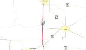
State Highway 160 (SH 160) is a Texas state highway that runs from SH 78 to U.S. Highway 69 and SH 11 in Whitewright. The route is about nine miles (14 km) in length. It was designated on March 19, 1930 along its current route, except that its north end was at Bells. It was a renumbering of SH 78A. On October 25, 1932, SH 160 was extended to Denison.[2] On September 26, 1939, the part from Denison to Whitewright was cancelled as it was cosigned with US 69.
| ||||
|---|---|---|---|---|
 | ||||
| Route information | ||||
| Maintained by TxDOT | ||||
| Length | 8.893 mi[1] (14.312 km) | |||
| Existed | 1930–present | |||
| Major junctions | ||||
| South end | ||||
| North end | ||||
| Location | ||||
| Counties | Collin, Grayson | |||
| Highway system | ||||
| ||||

Junction list
| County | Location | mi[3] | km | Destinations | Notes |
|---|---|---|---|---|---|
| Collin | Desert | 0.0 | 0.0 | ||
| 0.5 | 0.80 | ||||
| Grayson | | 3.5 | 5.6 | Western terminus of FM 814 | |
| | 4.4 | 7.1 | Eastern terminus of FM 814 | ||
| Whitewright | 8.9 | 14.3 | |||
| 1.000 mi = 1.609 km; 1.000 km = 0.621 mi | |||||
References
- Transportation Planning and Programming Division (n.d.). "State Highway No. 160". Highway Designation Files. Texas Department of Transportation. Retrieved June 21, 2015.
- (PDF) https://publicdocs.txdot.gov/minord/MinuteOrderDocLib/003673818.pdf. Missing or empty
|title=(help) - Google (June 21, 2015). "Texas State Highway 160" (Map). Google Maps. Google. Retrieved June 21, 2015.
This article is issued from Wikipedia. The text is licensed under Creative Commons - Attribution - Sharealike. Additional terms may apply for the media files.
