Texas State Highway 168
State Highway 168 (SH 168 or TX 168) is a short state highway located entirely within the city of Galveston in the U.S. state of Texas. The highway connects SH 87 to Coast Guard Station Galveston, on the eastern portion of Galveston Island. At just under 0.9 miles (1.4 km) in length, the highway is the second-shortest in the state, and the shortest signed highway (SH165, which is shorter, is officially designated but not signed). The road travels along the edge of residential area for most of its length before it bends northeast and runs through a small marsh.
| ||||
|---|---|---|---|---|
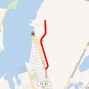
SH 168 highlighted in red | ||||
| Route information | ||||
| Maintained by TxDOT | ||||
| Length | 0.873 mi[1] (1.405 km) | |||
| Existed | 1985–present | |||
| Major junctions | ||||
| South end | ||||
| North end | Entrance gate to U.S. Coast Guard station | |||
| Highway system | ||||
| ||||

The route was first proposed by 1932; it would have traveled through Atascosa and Wilson counties. Portions of the proposal were replaced by SH 97 by at least 1935, while the rest was cancelled. State Highway 87 first followed the routing of SH 168, but was moved by 1961. A short railroad spur was built along the course of the route, and SH 168 was officially designated on October 24, 1985.
Route description
State Highway 168 begins at an at-grade intersection with SH 87, or Ferry Road, on the eastern portion of Galveston Island. The highway runs eastward for a short distance, being bordered by an apartment complex and a small gas station. After bending northward, the road enters rural areas, while following the course of a small, man-made drainage creek. The roadway continues northwest, bordered by marsh and brushland to the east and several resorts and apartment complexes to the west. It bends northeast and proceeds past a small portion of a U.S. Coast Guard station. The route splits away from the creek and continues past Corps Woods Nature Sanctuary, a major birdwatching destination.[2] The highway intersects a small access road to the Coast Guard station, before continuing northward to its northern terminus, the main entrance gate to the Coast Guard facility. A small road continues inside the station from the gate.[3][4]
The highway is maintained by the Texas Department of Transportation (TxDOT). Part of the TxDOT's job is to measure traffic along the highway. These counts are taken using a metric called annual average daily traffic (AADT), a statistical calculation of the average daily number of vehicles that travel along a portion of the highway. The TxDOT usually measures AADT near an intersection. In 2011, the highway's AADT count was 1500 vehicles, taken at a point just after the intersection with SH 87.[5] This was an increase from the previous year, when the AADT at the same point was approximately 1400 vehicles.[6] This was also an increase from 2009, when the route's AADT was just 1100 vehicles, also taken from the same point.[7] No portion of the roadway is listed on the National Highway System,[8] a network of roads important to the country's economy, defense, and mobility.[9]
History
State Highway 168 was first proposed on August 4, 1932,[10] traveling from Floresville in Wilson County to SH 81. The proposal was listed as a conditional designation, meaning that it would not be maintained by the State Highway Commission.[11] On January 9, 1933, it was extended to Campbellton in Atascosa County. On February 12, 1934, the portion from Campbellton to Floresville was cancelled and an extension of SH 97 to Floresville was substituted for it.[12] On March 13, 1934, SH 168 was cancelled, as it became part of SH 97.[13] On September 26, 1939, SH 87 was designated to a road that followed the general course of present-day SH 168.[14][15]
By 1961, the highway had been shifted westward, but a spur of the Gulf, Colorado and Santa Fe Railroad had been constructed along the approximate location of the highway's present route.[16][17] On October 24, 1985, SH 168 was approved for designation by the Texas Transportation Commission (TTC), and on April 18, 1986 the highway was officially designated by the TxDOT's Administration Circle. At the time, the road was approximately 0.5 miles (0.80 km) in length.[1] By 1994, the highway had been extended to approximately 0.9 miles (1.4 km) in length, due to an extension of its northern terminus.[18]
Junction list
The entire highway is in Galveston, Galveston County.
| mi[19] | km | Destinations | Notes | ||
|---|---|---|---|---|---|
| 0.000 | 0.000 | Southern terminus | |||
| 0.781 | 1.257 | Ferry Point Road | |||
| 0.873 | 1.405 | U.S. Coast Guard Station entrance gate | Northern terminus | ||
| 1.000 mi = 1.609 km; 1.000 km = 0.621 mi | |||||
See also
 Texas portal
 U.S. Roads portal
References
- Transportation Planning and Programming Division (n.d.). "State Highway No. 168". Highway Designation Files. Texas Department of Transportation. Retrieved July 16, 2013.
- Clark, Gary (April 6, 2013). "Galveston Island offers a host of bird-watching opportunities". The Houston Chronicle. Lifestyle. ISSN 1074-7109. Retrieved July 16, 2013. (subscription required)
- Google (July 16, 2013). "Overview Map of State Highway 168" (Map). Google Maps. Google. Retrieved July 16, 2013.
- Transportation Planning and Programming Division (2012). Texas County Mapbook (PDF) (Map) (2012 ed.). 1:120,000. Texas Department of Transportation. p. 583. OCLC 867856197. Retrieved July 16, 2013.
- Houston District Base Sheets (PDF) (Map) (2011 ed.). Cartography by Transportation Planning and Programming Division. Texas Department of Transportation. 2011. Map 8. Retrieved July 16, 2013.
- Houston District Base Sheets (PDF) (Map) (2011 ed.). Cartography by Transportation Planning and Programming Division. Texas Department of Transportation. 2011. Map 8. Retrieved July 16, 2013.
- Houston District Base Sheets (PDF) (Map) (2011 ed.). Cartography by Transportation Planning and Programming Division. Texas Department of Transportation. 2011. Map 8. Archived from the original (PDF) on February 21, 2012. Retrieved July 16, 2013.
- National Highway System: Galveston, TX (PDF) (Map). Cartography by FHWA. Federal Highway Administration. October 1, 2012. Retrieved July 16, 2013.
- Slater, Rodney E. (Spring 1996). "The National Highway System: A Commitment to America's Future". Public Roads. Washington, DC: Federal Highway Administration. 59 (4). ISSN 0033-3735. Retrieved July 16, 2013.
- Texas State Highway Department. "Minute Orders of the August 4, 1932 Meeting of the Texas State Highway Department" (PDF). Austin, TX. Retrieved October 30, 2019.
- Texas State Highway Commission (June 15, 1933). Official Map of the Highway System of Texas (Map) (1933 ed.). [c. 1:2,154,240]. Austin: Texas State Highway Commission. § P19-Q20. OCLC 925481750. Retrieved July 16, 2013.
- Texas State Highway Department. "Minute Orders of the January 9, 1933 Meeting of the Texas State Highway Department" (PDF). Austin, TX. Retrieved October 30, 2019.
- Texas State Highway Department. "Minute Orders of the March 13, 1934 Meeting of the Texas State Highway Department" (PDF). Austin, TX. Retrieved October 30, 2019.
- Transportation Planning and Programming Division (n.d.). "State Highway No. 87". Highway Designation Files. Texas Department of Transportation. Retrieved July 17, 2013.
- General Highway Map Galveston County Texas (Map) (1936 ed.). 1 in=2 mi. Cartography by State-Wide Highway Planning Survey. Texas State Highway Department. February 1, 1940. OCLC 45871736.
- City Map Galveston and Vicinity–Galveston County, Texas (Map) (1957 ed.). 1 in=0.2 mi. Cartography by State-Wide Highway Planning Survey. Texas State Highway Department. January 1, 1961.
- Werner, George C. (2013). "Gulf, Colorado and Santa Fe Railroad". Handbook of Texas Online. Texas State Historical Association. Retrieved July 17, 2013.
- General Highway Map Galveston County Texas–Supplementary Sheet 6073 (Map) (1990 ed.). 1 in=0.5 mi. Cartography by Transportation Planning and Programming Division. Texas Department of Transportation. January 1, 1994.
- Statewide Planning Map (Map). Cartography by Transportation Planning and Programming Division. Texas Department of Transportation. 2013. Retrieved July 16, 2013.